Your at 800 feet, thermals are playing out, you see the landing zone about a mile away and wonder if you can make it. No time to second guess, so you check your glide path with your GPS system. The GPS checks your location in reference to the landing zone, calculates the distance between, calculates the vertical difference, and then based upon your glide path, says go for it. No back pasture landing today.
Today’s GPS (Global Positioning Systems) are becoming smarter than ever, allowing even the greenest of cross country novice pilots to make judgements that were once only successfully made by seasoned experienced pilots. A GPS on the control bar can mean the difference between making the LZ and scraping the tree tops.
What is GPS and how did it all get started? Contrary to popular belief, the GPS was not invented by the airlines but rather it was built by the U.S. Military at a cost of over 12 billion dollars back in the 80’s. The original intent of this system was to provide navigational support for the military planes. It has evolved into a worldwide “where am I” system used by every country for navigation of aircrafts, mapping, surveying, earth sciences, hiking, camping, fishing, and of course, gliding our crafts to safe landing zones.
There are 24 satellite that orbit the earth in 24 hours. Of these 24 satellites which orbit at approximately 110,000 feet, only 21 of them are in use while the other 3 are backups in case of failure. The satellite repeats approximately the same ground track every day. Each satellite has 4 atomic clocks aboard. The satellite broadcasts a time signal and satellite location to our receivers on the gliders approximately every six seconds. At any point on the earth there is always 5 to 8 GPS signals available which insures that no matter where you fly, there is always GPS to track you.
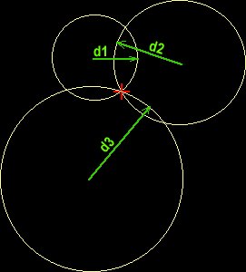
Four satellites are required to compute four dimension of a glider, the x,y, z, and time coordinates of the glider. The way GPS calculates your position is through the use of triangulation. Triangulation is a math formula that states, if you know the distance between any 3 known points, you can find your position in reference to these points. As our example shows below, if you know the distance between any two points there are only 2 points that they can intersect.

If we take a third measurement it will eliminate one of these two points.

The above example works all solutions in a 2 dimensional plane. When we get in the 3 dimensional world, as what we fly in, there is another intersection for the 3 distances. For this reason, we need a fourth satellite to eliminate one of these two points.
Accurate timing is the key to measuring distance to satellites. The way your receiver calculates its distance to the satellite is by measuring the amount of time it takes for the signal to travel from the satellite to your receiver. After applying various corrections for atmospheric conditions, it solves for the how long the signal took to travel. By knowing the time of travel and multiplying it by the speed of sound, your receiver can calculate the distance from your glider to the satellite. Each satellite has its own unique broadcast code so your reciever knows which satellite it is receiving. With these 4 distances, there is only 1 point on earth where you can be in reference to the satellites.
We now have our 4 distances, all we need now is the location of the satellites to plot our position on earth. Due to slight variations in satellite location and minute differences in the atomic clocks on board, the satellites are updated by the master control unit at Schriever Airforce base in Colorado. The master control unit models each satellite position with the use of radar and sends corrections to the each satellite for broadcast twice a day. These corrected coordinates are transmitted to your receiver, which in turn are used to calculate your latitude, longitude, speed of flight, and elevation above the earth. With these coordinates, we can tell where we are, what direction we are heading, how long it will take us to get to our goal, and with the help of topographic modeling software, define what features lies between us and our goal.
The GPS receivers that are used by most of us are not extremely accurate. A few hundred feet is the best we can expect. The military puts error into the signal for defense purposes. The Military uses other GPS channels that are extremely accurate to fractions of an inch. To use these precise channels you must make application and get a special decoder.
There are other ways to get accurate results with the common GPS channel that involve land based differential GPS transmitters. These land systems are used to verify the accuracy of the receivers location and providing error correcting formulas for use by the receiver.
In all, the Global positioning system is a lot more complex than it is explained here. To truly explain the methods and math would require several pages beyond this writers interest. If you would like to find out more about GPS, go to your favorite search engine on the internet and type in ‘Global Positioning System’. You should have several hours of surfing before you to satisfy that calculus craving.


