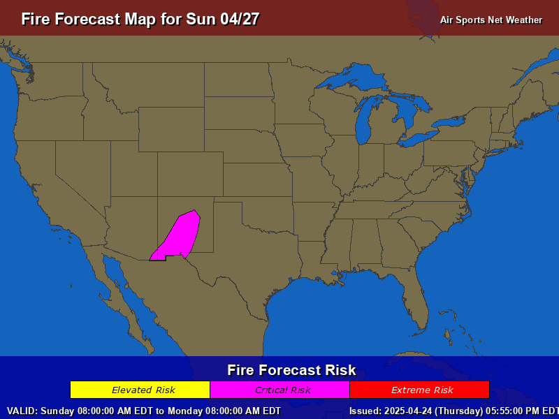
...CRITICAL FIRE WEATHER AREA FOR PARTS OF WESTERN OKLAHOMA...THE EASTERN TEXAS/OKLAHOMA PANHANDLES...AND FAR SOUTH-CENTRAL KANSAS...
...Eastern NM into the TX Panhandle...northwestern OK and far south-central KS... Breezy and dry conditions associated within a post-frontal regime will bring a corridor of critical fire weather conditions to portions of the TX Panhandle, northwestern OK and far southern KS through this afternoon. Northeast winds of 15-25 mph with higher gusts will only slowly diminish through the afternoon hours. A local minima of cloud cover evolving across the TX/OK Panhandles into eastern NM will support better boundary layer mixing and lower relative humidity of around 20% this afternoon. This combined with the stronger northeast winds and exceptionally dry fuels will support a critical fire weather environment today. The western portions of the existing elevated and critical highlights were extended westward based on limited cloud cover and latest short term model guidance.
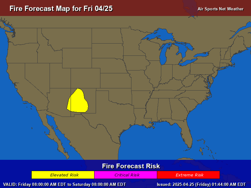
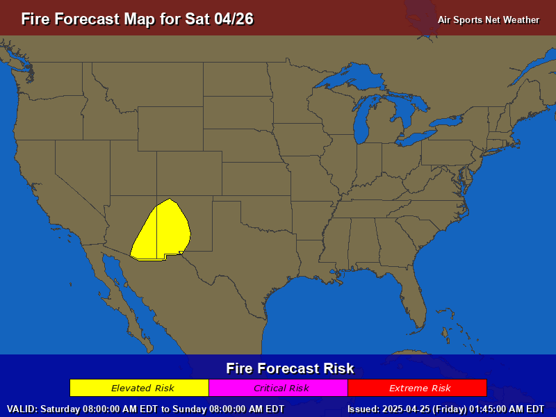
...Eastern Arizona into Southwestern New Mexico... The backdoor cold front will continue to bring gusty northeast winds into portions of the Lower Colorado River Basin today. Localized wind gusts of around 60 mph have been observed on the leeward portions of mountain ranges in southern NM within a broader northeast wind field of 15-25 mph. Extended the existing Elevated highlights northeastward into south-central NM based on these current observation and short term guidance trends. Relative humidity reductions will be more limited across the south-central NM as cooler temperatures filter into the area, but as low as 10% farther west into southeastern AZ. These dry and breezy conditions, along with very dry fuels will support an elevated fire weather concern through today.
..Williams.. 03/27/2026
...Synopsis... Upper-level ridging centered over northern Mexico and West Texas will remain in place today as a mid-level shortwave trough moves southeastward across the Great Lakes and Northeast. At the surface, strong high pressure will shift southeastward from the northern Great Plains into the Midwest while a cold front progresses southward across the southern Great Plains and Southeast.
...Eastern TX/OK Panhandles into western OK and far south-central KS... Broad north-northeasterly post-frontal flow amid a dry air mass will encompass portions of the central/southern Great Plains today. While the latest guidance indicates RH values will remain more marginal (20-25%), receptive fuels, sustained northeasterly surface winds of 20-25 mph, and the potential for occasional wind gusts of 30-40 mph (locally higher) should support a period of critical fire weather concerns from the eastern TX/OK Panhandles into far south-central Kansas.
Farther northeast, minimum RH values are forecast to range from 20-30% across much of central/eastern Kansas northward into eastern Nebraska, southwestern Iowa, and northwestern Missouri. Coupled with receptive fuels and sustained surface winds of 15-20 mph, elevated to locally critical fire weather conditions are expected this afternoon, with the exception being across areas that saw appreciable rainfall Thursday evening.
...Eastern Arizona into Southwestern New Mexico... A backdoor cold front will progress south-southwestward through portions of the Southwest today. Dry and breezy conditions are forecast in the wake of this front, with the latest guidance depicting a corridor of 15-25 mph sustained southeasterly surface winds overlapping low RH around 20%. These conditions atop receptive fuels are expected to promote a few hours of elevated fire weather conditions this afternoon, particularly in the vicinity of the White Mountains and Gila Region.
General Precautions for Fire Weather
Stay Informed: Monitor weather forecasts and fire warnings from official sources like [Local Fire Department, National Weather Service, etc. Have a battery-powered radio in case of power outages.
Be Aware of Your Surroundings: Pay close attention to your surroundings and be aware of any signs of fire, such as smoke or unusual fire behavior.
Be Ready to Evacuate
Prepare a "Go Bag": Have a readily accessible bag with essential items in case of evacuation, including:
Water
Non-perishable food
First-aid kit
Medications
Flashlight with extra batteries
Important documents (copies)
Clothing for all weather conditions
Cell phone and charger
Pet supplies (if applicable)
Be Prepared
Create a Wildfire Action Plan: Discuss a wildfire action plan with your family, including evacuation routes and meeting points. Practice your plan regularly.
Prepare your Home
Maintain Your Property:
Clear brush and debris around your home.
Keep lawns and vegetation trimmed.
Ensure your address is clearly visible from the street.
Inspect and maintain outdoor equipment (mowers, chainsaws, etc.) to prevent sparks.
Avoid Activities that Could Spark a Fire:
Refrain from open burning, including campfires and backyard fires.
Be extremely careful with smoking materials.
Avoid using fireworks.
Be cautious when operating machinery that could produce sparks, especially in dry grass or brush.
Ensure vehicles are in good working order, with no dragging parts that could create sparks.
If a Wildfire Threatens Your Area:
Evacuate Immediately: If you are advised to evacuate, do so immediately. Do not wait until the last minute.
Follow Evacuation Routes: Follow designated evacuation routes and do not take shortcuts.
Stay Informed: Listen to official sources for updates and instructions.
If Trapped: If you cannot evacuate, seek shelter in a sturdy building away from vegetation. Close all doors and windows and stay inside until it is safe to leave.
Remember: Wildfires can spread quickly and unexpectedly. Being prepared and taking precautions can significantly reduce your risk. Your safety is your responsibility.