Wetumpka, Florida Weather
Issued: 4:15 am EDT May 6, 2024 Latitude: 30.4829738 Longitude: -84.6229672 View on Google Maps
|
|
|
|
|
|
|
|
|
|
 |
 |
 |
|
 |
 |
 |
|
| Low: °F |
High: °F |
High: °F |
High: °F |
High: °F |
High: °F |
High: °F |
High: °F |
| Low: °F |
Low: °F |
Low: °F |
Low: °F |
Low: °F |
Low: °F |
|
| Fog |
Thunderstorms |
Mostly Sunny |
Mostly Sunny |
Thunderstorms |
Thunderstorms |
Thunderstorms |
Thunderstorms |
Current Conditions at
TALLAHASSEE - (KTLH)
72°
Clear
Fog
as of 4:12 AM EDST
Rel. Humidity: 100%
Dew Point: 72°F
Visibility: 1/4 Miles
Pressure: 30.00 in.
Flight Rule: IFR
Current Conditions at
BAINBRIDGE - (KBGE)
68°
Clear
as of 4:15 AM EDST
Rel. Humidity: 93%
Dew Point: 66°F
Visibility: 10 Miles
Pressure: 30.00 in.
Flight Rule: VFR
Wind Data
6 MPH
120° Southeast
Cloud Level(s): Clear
Current Conditions at
MARIANNA - (KMAI)
68°
Mostly Cloudy
as of 3:33 AM CDST
Rel. Humidity: 100%
Dew Point: 68°F
Visibility: 10 Miles
Pressure: 29.98 in.
Flight Rule: LIFR
Cloud Level(s): Broken at 300ft
Current Conditions at
APALACHICOLA - (KAAF)
73°
Partly Cloudy
as of 4:24 AM EDST
Rel. Humidity: 94%
Dew Point: 72°F
Visibility: 10 Miles
Pressure: 29.98 in.
Flight Rule: VFR
Wind Data
6 MPH
130° Southeast
Cloud Level(s): Scattered at 1600ft
|
Overnight... Areas of dense fog. Otherwise, partly cloudy, with a low around 67. Calm wind. |
|
|
Monday... A 20 percent chance of showers and thunderstorms after 1pm. Areas of dense fog before 10am. Otherwise, partly sunny, with a high near 90. Light south southeast wind becoming south 5 to 10 mph in the morning. |
|
 |
Monday Night... Increasing clouds, with a low around 66. South southwest wind around 5 mph. |
|
|
Tuesday... Mostly sunny, with a high near 90. Light south wind becoming south southwest 5 to 10 mph in the morning. |
|
 |
Tuesday Night... Partly cloudy, with a low around 68. South southwest wind 5 to 10 mph. |
|
|
Wednesday... Mostly sunny, with a high near 91. |
|
|
Wednesday Night... Partly cloudy, with a low around 70. |
|
|
Thursday... A 30 percent chance of showers and thunderstorms after 2pm. Mostly sunny, with a high near 91. Breezy. |
|
 |
Thursday Night... A chance of showers and thunderstorms before 8pm, then a chance of showers and thunderstorms after 2am. Mostly cloudy, with a low around 69. Breezy. Chance of precipitation is 30%. |
|
|
Friday... Showers and thunderstorms likely, mainly after 8am. Mostly cloudy, with a high near 82. Chance of precipitation is 70%. |
|
|
Friday Night... Partly cloudy, with a low around 60. |
|
|
Saturday... A 20 percent chance of showers and thunderstorms. Mostly sunny, with a high near 81. |
|
 |
Saturday Night... A 10 percent chance of showers and thunderstorms. Partly cloudy, with a low around 59. |
|
|
Sunday... A 20 percent chance of showers and thunderstorms. Mostly sunny, with a high near 82. |
|
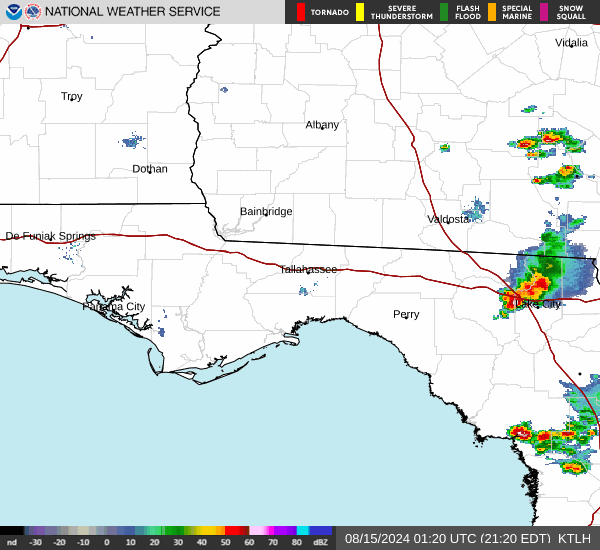
Current Radar Image
Sun Almanac for Wetumpka, Florida
Sunrise: 06:50 AM
Sunset: 8:20 PM
Civil Sunrise:06:24 AM
Civil Sunset: 8:46 PM
Nautical Sunrise: 05:53 AM
Nautical Sunset: 9:17 PM
Astro Sunrise: 05:21 AM
Astro Sunset: 9:49 PM
Florida's Current Temperatures
 Florida's Satellite Image
 Florida's Current Wind Direction
| National Summary |
of upper and lower values of current conditions amongst 7030 locations
in the contiguous United States |
|
High
Temp |
84° |
Key West NAS, Florida
|
|
Low
Temp |
30° |
Kemmerer, Wyoming
and 9 other locations
|
|
Wind
Speed |
55mph |
Salida Mountain, Colorado
|
|
Wind
Gust |
78mph |
Pagosa Springs, Colorado
|
|
Wind
Chill |
13° |
Berthoud Pass, Colorado
|
|
High
Pressure |
30.82Hg |
Ottawa, Ohio
|
|
Low
Pressure |
29.35Hg |
Guernsey, Wyoming
|
|
| # Locations Reporting Snow |
17 |
|
| # Locations Reporting Rain |
110 |
|
| # Locations Reporting Thunderstorms / Lightning |
4 |
|
| # Locations Reporting Fog |
78 |
|
| Average Temperature in the Contiguous USA |
57° |
|
Any use of the information on this page is at your own risk. This information should not be relied upon in life-threatening situations, potential financial loss situations or in lieu of any officially disseminated information. Visit the
National Weather Service for official information.