No Watches or Warnings for Wettick
Issued: 2:02 am CDT May 3, 2024 Latitude: 37.796688 Longitude: -100.2643085 View on Google Maps
|
|
|
|
|
|
|
|
|
|
 |
 |
 |
 |
 |
 |
|
|
| Low: °F |
High: °F |
High: °F |
High: °F |
High: °F |
High: °F |
High: °F |
High: °F |
| Low: °F |
Low: °F |
Low: °F |
Low: °F |
Low: °F |
Low: °F |
|
| Cloudy |
Mostly Sunny |
Thunderstorms |
Thunderstorms |
Thunderstorms |
Sunny |
Sunny |
Sunny |
Current Conditions at
DODGE CITY - (KDDC)
52°
Clear
as of 1:52 AM CDST
Rel. Humidity: 76%
Dew Point: 45°F
Visibility: 10 Miles
Pressure: 29.97 in.
Flight Rule: VFR
Cloud Level(s): Clear
Current Conditions at
GARDEN CITY - (KGCK)
48°
Partly Cloudy
as of 1:54 AM CDST
Rel. Humidity: 61%
Dew Point: 36°F
Visibility: 10 Miles
Pressure: 29.98 in.
Flight Rule: VFR
Cloud Level(s): Scattered at 6000ft
Current Conditions at
LIBERAL - (KLBL)
55°
Partly Cloudy
as of 1:56 AM CDST
Rel. Humidity: 76%
Dew Point: 48°F
Visibility: 10 Miles
Pressure: 29.97 in.
Flight Rule: VFR
Cloud Level(s): Few at 3800ft, Scattered at 5000ft
Current Conditions at
PRATT - (KPTT)
54°
Clear
as of 1:50 AM CDST
Rel. Humidity: 81%
Dew Point: 48°F
Visibility: 10 Miles
Pressure: 29.97 in.
Flight Rule: VFR
Wind Data
3 MPH
060° Northeast
Cloud Level(s): Clear
|
Overnight... Partly cloudy, with a low around 43. East wind 8 to 10 mph. |
|
|
Friday... Mostly sunny, with a high near 76. East wind 8 to 18 mph becoming south in the afternoon. Winds could gust as high as 28 mph. |
|
 |
Friday Night... A chance of showers and thunderstorms, then showers and possibly a thunderstorm after 1am. Some of the storms could be severe and produce heavy rainfall. Low around 46. South southeast wind 14 to 18 mph becoming north after midnight. Winds could gust as high as 28 mph. Chance of precipitation is 90%. New rainfall amounts between 1 and 2 inches possible. |
|
|
Saturday... A 30 percent chance of showers and thunderstorms before 7am. Partly sunny, with a high near 64. Breezy, with a north wind 15 to 21 mph. |
|
 |
Saturday Night... A slight chance of showers, then a chance of showers and thunderstorms after 1am. Mostly cloudy, with a low around 46. East wind 9 to 13 mph. Chance of precipitation is 30%. |
|
|
Sunday... A 30 percent chance of showers and thunderstorms, mainly before 1pm. Mostly cloudy, with a high near 70. |
|
 |
Sunday Night... A 20 percent chance of showers and thunderstorms after 1am. Mostly cloudy, with a low around 55. Very windy. |
|
|
Monday... A 30 percent chance of showers and thunderstorms, mainly after 1pm. Mostly sunny, with a high near 81. Very windy. |
|
 |
Monday Night... Mostly clear, with a low around 45. Windy. |
|
|
Tuesday... Sunny, with a high near 81. Breezy. |
|
|
Tuesday Night... Mostly clear, with a low around 45. |
|
|
Wednesday... Sunny, with a high near 78. |
|
|
Wednesday Night... Mostly clear, with a low around 45. |
|
|
Thursday... Sunny, with a high near 74. |
|
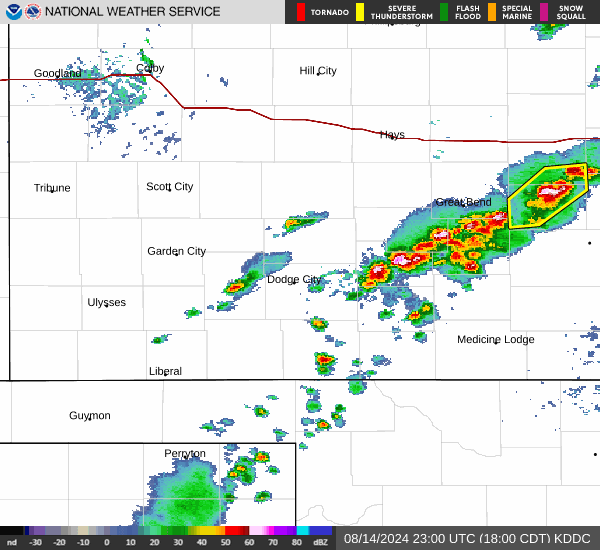
Current Radar Image
Sun Almanac for Wettick, Kansas
Sunrise: 06:42 AM
Sunset: 8:34 PM
Civil Sunrise:06:14 AM
Civil Sunset: 9:02 PM
Nautical Sunrise: 05:39 AM
Nautical Sunset: 9:37 PM
Astro Sunrise: 05:02 AM
Astro Sunset: 10:14 PM
Kansas' Current Temperatures
 Kansas' Satellite Image
 Kansas' Current Wind Direction
| National Summary |
of upper and lower values of current conditions amongst 6849 locations
in the contiguous United States |
|
High
Temp |
82° |
Corpus Christi NAS, Texas
|
|
Low
Temp |
30° |
Dubois Municipal, Wyoming
and 15 other locations
|
|
Wind
Speed |
25mph |
Berthoud Pass, Colorado
|
|
Wind
Gust |
33mph |
Berthoud Pass, Colorado
|
|
Wind
Chill |
16° |
Charlie, Montana
|
|
High
Pressure |
30.26Hg |
Salida Mountain, Colorado
|
|
Low
Pressure |
29.56Hg |
Roseau, Minnesota
|
|
| # Locations Reporting Snow |
13 |
|
| # Locations Reporting Rain |
133 |
|
| # Locations Reporting Thunderstorms / Lightning |
6 |
|
| # Locations Reporting Fog |
37 |
|
| Average Temperature in the Contiguous USA |
57° |
|
Any use of the information on this page is at your own risk. This information should not be relied upon in life-threatening situations, potential financial loss situations or in lieu of any officially disseminated information. Visit the
National Weather Service for official information.