Yankton, South Dakota Weather
No Watches or Warnings for Yankton
Issued: 3:46 am CDT May 3, 2024 Latitude: 42.8711088 Longitude: -97.3972813 View on Google Maps
|
|
|
|
|
|
|
|
|
|
 |
 |
 |
 |
 |
 |
|
 |
| High: °F |
Low: °F |
High: °F |
High: °F |
High: °F |
High: °F |
High: °F |
High: °F |
| Low: °F |
Low: °F |
Low: °F |
Low: °F |
Low: °F |
|
| Increasing Clouds |
Thunderstorms |
Rain |
Sunny |
Thunderstorms |
Mostly Sunny |
Mostly Sunny |
Partly Sunny |
Current Conditions at
YANKTON - (KYKN)
45°
Clear
as of 2:56 AM CDST
Rel. Humidity: 75%
Dew Point: 37°F
Visibility: 10 Miles
Pressure: 29.94 in.
Flight Rule: VFR
Wind Data
3 MPH
220° Southwest
Cloud Level(s): Clear
Current Conditions at
WAYNE - (KLCG)
Current Conditions at
SIOUX FALLS - (KFSD)
46°
Clear
as of 2:56 AM CDST
Rel. Humidity: 70%
Dew Point: 37°F
Visibility: 10 Miles
Pressure: 29.92 in.
Flight Rule: VFR
Wind Data
6 MPH
210° Southwest
Cloud Level(s): Clear
Current Conditions at
LE MARS - (KLRJ)
Clear
as of 3:35 AM CDST
Visibility: 10 Miles
Pressure: 29.95 in.
Flight Rule: VFR
Cloud Level(s): Clear
|
Today... Increasing clouds, with a high near 69. Southwest wind 5 to 10 mph, with gusts as high as 20 mph. |
|
|
Tonight... Showers and possibly a thunderstorm before 4am, then a chance of showers. Low around 44. East southeast wind 10 to 15 mph becoming north northwest in the evening. Winds could gust as high as 30 mph. Chance of precipitation is 90%. New rainfall amounts between a tenth and quarter of an inch, except higher amounts possible in thunderstorms. |
|
|
Saturday... A 30 percent chance of showers, mainly before 7am. Sunny, with a high near 63. North northwest wind 10 to 15 mph, with gusts as high as 20 mph. |
|
 |
Saturday Night... Clear, with a low around 39. North northwest wind 5 to 10 mph becoming southeast after midnight. |
|
|
Sunday... Sunny, with a high near 68. Southeast wind 5 to 10 mph increasing to 10 to 15 mph in the afternoon. Winds could gust as high as 20 mph. |
|
 |
Sunday Night... A 20 percent chance of showers after 1am. Increasing clouds, with a low around 53. Breezy, with a southeast wind 20 to 25 mph, with gusts as high as 35 mph. |
|
|
Monday... A chance of showers, then showers and possibly a thunderstorm after 1pm. High near 73. Breezy. Chance of precipitation is 80%. |
|
 |
Monday Night... Showers likely and possibly a thunderstorm before 1am, then a chance of showers and thunderstorms after 1am. Mostly cloudy, with a low around 50. Breezy. Chance of precipitation is 70%. |
|
|
Tuesday... Mostly sunny, with a high near 70. Breezy. |
|
 |
Tuesday Night... Partly cloudy, with a low around 47. |
|
|
Wednesday... Mostly sunny, with a high near 66. |
|
|
Wednesday Night... Partly cloudy, with a low around 45. |
|
|
Thursday... Partly sunny, with a high near 62. Breezy. |
|
Current Radar Image
Sun Almanac for Yankton, South Dakota
Sunrise: 06:20 AM
Sunset: 8:33 PM
Civil Sunrise:05:49 AM
Civil Sunset: 9:04 PM
Nautical Sunrise: 05:10 AM
Nautical Sunset: 9:43 PM
Astro Sunrise: 04:27 AM
Astro Sunset: 10:26 PM
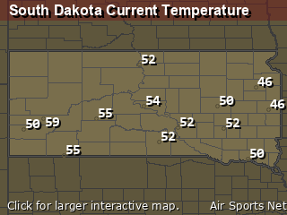
South Dakota's Current Temperatures
 South Dakota's Satellite Image
 South Dakota's Current Wind Direction
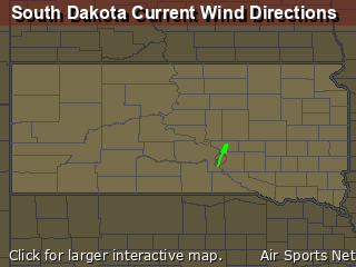
| National Summary |
of upper and lower values of current conditions amongst 7029 locations
in the contiguous United States |
|
High
Temp |
82° |
Key West NAS, Florida
and 1 other location
|
|
Low
Temp |
30° |
Pinedale, Wyoming
and 15 other locations
|
|
Wind
Speed |
29mph |
Mojave, California
|
|
Wind
Gust |
39mph |
Mojave, California
|
|
Wind
Chill |
16° |
Charlie, Montana
|
|
High
Pressure |
30.23Hg |
Salida Mountain, Colorado
|
|
Low
Pressure |
29.56Hg |
Warroad, Minnesota
and 1 other location
|
|
| # Locations Reporting Snow |
12 |
|
| # Locations Reporting Rain |
124 |
|
| # Locations Reporting Thunderstorms / Lightning |
11 |
|
| # Locations Reporting Fog |
67 |
|
| Average Temperature in the Contiguous USA |
57° |
|
Any use of the information on this page is at your own risk. This information should not be relied upon in life-threatening situations, potential financial loss situations or in lieu of any officially disseminated information. Visit the
National Weather Service for official information.


