Watertown, South Dakota Weather
No Watches or Warnings for Watertown
Issued: 4:47 pm CDT Jul 5, 2025 Latitude: 44.8994088 Longitude: -97.1150732 View on Google Maps
|
|
|
|
|
|
|
|
|
|
 |
 |
 |
 |
|
 |
 |
|
| Low: °F |
High: °F |
High: °F |
High: °F |
High: °F |
High: °F |
High: °F |
High: °F |
| Low: °F |
Low: °F |
Low: °F |
Low: °F |
Low: °F |
Low: °F |
|
| Mostly Clear |
Mostly Sunny |
Thunderstorms |
Sunny |
Mostly Sunny |
Thunderstorms |
Thunderstorms |
Sunny |
Current Conditions at
WATERTOWN - (KATY)
77°
Partly Cloudy
as of 4:33 PM CDST
Rel. Humidity: 73%
Dew Point: 68°F
Visibility: 10 Miles
Pressure: 29.95 in.
Flight Rule: VFR
Wind Data
20 MPH
Gust: 26 MPH
340° North
Cloud Level(s): Scattered at 2000ft
Current Conditions at
ORTONVILLE - (KVVV)
81°
Mostly Cloudy
as of 4:43 PM CDST
Rel. Humidity: 74%
Dew Point: 72°F
Visibility: 10 Miles
Pressure: 29.92 in.
Flight Rule: MVFR
Wind Data
16 MPH
Gust: 21 MPH
340° North
Cloud Level(s): Scattered at 2100ft, Broken at 2800ft, Broken at 11000ft
Current Conditions at
BROOKINGS - (KBKX)
81°
Mostly Cloudy
as of 4:14 PM CDST
Rel. Humidity: 69%
Dew Point: 70°F
Visibility: 10 Miles
Pressure: 29.93 in.
Flight Rule: VFR
Wind Data
13 MPH
330° Northwest
Cloud Level(s): Scattered at 2800ft, Broken at 3600ft, Broken at 4400ft
Current Conditions at
MADISON - (KDXX)
84°
Partly Cloudy
as of 4:35 PM CDST
Rel. Humidity: 70%
Dew Point: 73°F
Visibility: 10 Miles
Pressure: 29.92 in.
Flight Rule: VFR
Wind Data
20 MPH
Gust: 24 MPH
340° North
Cloud Level(s): Scattered at 3000ft
|
Tonight... Mostly clear, with a low around 54. North wind 6 to 16 mph. |
|
|
Sunday... Mostly sunny, with a high near 77. North northeast wind around 6 mph. |
|
 |
Sunday Night... Partly cloudy, with a low around 59. East northeast wind around 6 mph becoming calm after midnight. |
|
|
Monday... A chance of showers and thunderstorms after 1pm. Mostly sunny, with a high near 81. Light and variable wind becoming south southwest 5 to 7 mph in the morning. Chance of precipitation is 30%. |
|
 |
Monday Night... A chance of showers and thunderstorms. Partly cloudy, with a low around 62. Southwest wind 3 to 7 mph. Chance of precipitation is 40%. |
|
|
Tuesday... Sunny, with a high near 83. West wind 3 to 7 mph. |
|
|
Tuesday Night... Mostly clear, with a low around 63. South southeast wind 3 to 6 mph. |
|
|
Wednesday... Mostly sunny, with a high near 84. South wind 5 to 9 mph. |
|
 |
Wednesday Night... A slight chance of showers and thunderstorms after 1am. Partly cloudy, with a low around 65. South southeast wind around 9 mph. Chance of precipitation is 20%. |
|
|
Thursday... A slight chance of showers and thunderstorms after 1pm. Mostly sunny, with a high near 85. Chance of precipitation is 20%. |
|
 |
Thursday Night... Showers and thunderstorms likely. Mostly cloudy, with a low around 63. Chance of precipitation is 60%. |
|
|
Friday... A chance of showers and thunderstorms. Mostly cloudy, with a high near 75. Chance of precipitation is 40%. |
|
|
Friday Night... A slight chance of showers and thunderstorms. Partly cloudy, with a low around 56. Chance of precipitation is 20%. |
|
|
Saturday... Sunny, with a high near 76. |
|
Current Radar Image
Sun Almanac for Watertown, South Dakota
Sunrise: 05:49 AM
Sunset: 9:17 PM
Civil Sunrise:05:12 AM
Civil Sunset: 9:54 PM
Nautical Sunrise: 04:24 AM
Nautical Sunset: 10:42 PM
Astro Sunrise: 03:22 AM
Astro Sunset: 11:45 PM
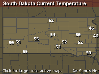
South Dakota's Current Temperatures
 South Dakota's Satellite Image
 South Dakota's Current Wind Direction
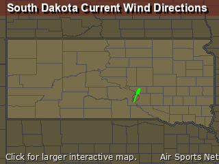
| National Summary |
of upper and lower values of current conditions amongst 6940 locations
in the contiguous United States |
|
High
Temp |
108° |
Palm Springs, California
and 1 other location
|
|
Low
Temp |
54° |
Mullan Pass, Idaho
|
|
Wind
Speed |
30mph |
Dubuque, Iowa
|
|
Wind
Gust |
43mph |
Milford, Utah
|
|
Heat
Index |
113° |
Corning Municipal A/P, Arkansas
|
|
High
Pressure |
30.81Hg |
Salida Mountain, Colorado
|
|
Low
Pressure |
29.80Hg |
Oconto, Wisconsin
and 3 other locations
|
|
| # Locations Reporting Rain |
79 |
|
| # Locations Reporting Thunderstorms / Lightning |
22 |
|
| # Locations Reporting Fog |
1 |
|
| Average Temperature in the Contiguous USA |
84° |
|
Any use of the information on this page is at your own risk. This information should not be relied upon in life-threatening situations, potential financial loss situations or in lieu of any officially disseminated information. Visit the
National Weather Service for official information.


