Trenton, New Jersey Weather
Issued: 4:11 pm EDT Jun 23, 2025 Latitude: 40.2170534 Longitude: -74.7429385 View on Google Maps
|
|
|
|
|
|
|
|
|
|
 |
 |
 |
 |
 |
 |
 |
 |
| Low: °F |
High: °F |
High: °F |
High: °F |
High: °F |
High: °F |
High: °F |
High: °F |
| Low: °F |
Low: °F |
Low: °F |
Low: °F |
Low: °F |
Low: °F |
|
| Mostly Clear |
Sunny |
Thunderstorms |
Thunderstorms |
Thunderstorms |
Thunderstorms |
Thunderstorms |
Partly Sunny |
Current Conditions at
TRENTON - (KTTN)
84°
Clear
as of 11:53 PM EDST
Rel. Humidity: 70%
Dew Point: 73°F
Visibility: 10 Miles
Pressure: 30.07 in.
Flight Rule: VFR
Cloud Level(s): Clear
Current Conditions at
MCGUIRE AFB - (KWRI)
81°
Clear
as of 11:55 PM EDST
Rel. Humidity: 88%
Dew Point: 77°F
Visibility: 10 Miles
Pressure: 30.06 in.
Flight Rule: VFR
Cloud Level(s): Clear
Current Conditions at
N PHILADELPHIA - (KPNE)
Clear
as of 11:54 PM EDST
Rel. Humidity: 66%
Dew Point: 73°F
Visibility: 10 Miles
Pressure: 30.09 in.
Flight Rule: VFR
Cloud Level(s): Clear
Current Conditions at
MOUNT HOLLY - (KVAY)
84°
Clear
as of 11:54 PM EDST
Rel. Humidity: 70%
Dew Point: 73°F
Visibility: 10 Miles
Pressure: 30.07 in.
Flight Rule: VFR
Wind Data
5 MPH
240° Southwest
Cloud Level(s): Clear
|
Overnight... Mostly clear, with a low around 78. Calm wind. |
|
|
Tuesday... Sunny and hot, with a high near 101. Heat index values as high as 106. Calm wind becoming northwest around 5 mph in the afternoon. |
|
|
Tuesday Night... Mostly clear, with a low around 79. Northwest wind around 5 mph becoming calm. |
|
|
Wednesday... A chance of showers and thunderstorms after 2pm. Sunny and hot, with a high near 97. Heat index values as high as 101. Calm wind becoming northwest around 5 mph in the afternoon. Chance of precipitation is 30%. New rainfall amounts of less than a tenth of an inch, except higher amounts possible in thunderstorms. |
|
 |
Wednesday Night... A chance of showers and thunderstorms, mainly before 2am. Partly cloudy, with a low around 74. Calm wind. Chance of precipitation is 30%. New rainfall amounts of less than a tenth of an inch, except higher amounts possible in thunderstorms. |
|
|
Thursday... A slight chance of showers before 2pm, then showers likely and possibly a thunderstorm between 2pm and 5pm, then showers and thunderstorms likely after 5pm. Partly sunny, with a high near 90. Chance of precipitation is 60%. New rainfall amounts between a tenth and quarter of an inch, except higher amounts possible in thunderstorms. |
|
 |
Thursday Night... Showers and thunderstorms likely before 2am, then a chance of showers. Mostly cloudy, with a low around 67. Chance of precipitation is 60%. |
|
|
Friday... A chance of showers and thunderstorms after 2pm. Mostly cloudy, with a high near 78. Chance of precipitation is 30%. |
|
 |
Friday Night... A chance of showers and thunderstorms. Mostly cloudy, with a low around 66. Chance of precipitation is 40%. |
|
|
Saturday... A chance of showers and thunderstorms after 2pm. Mostly cloudy, with a high near 86. Chance of precipitation is 40%. |
|
 |
Saturday Night... A chance of showers and thunderstorms. Mostly cloudy, with a low around 71. Chance of precipitation is 30%. |
|
|
Sunday... A chance of showers and thunderstorms. Mostly sunny, with a high near 90. Chance of precipitation is 30%. |
|
|
Sunday Night... A chance of showers and thunderstorms. Partly cloudy, with a low around 72. Chance of precipitation is 30%. |
|
|
Monday... A chance of showers. Partly sunny, with a high near 91. Chance of precipitation is 40%. |
|
Current Radar Image
Sun Almanac for Trenton, New Jersey
Sunrise: 05:31 AM
Sunset: 8:32 PM
Civil Sunrise:04:58 AM
Civil Sunset: 9:06 PM
Nautical Sunrise: 04:16 AM
Nautical Sunset: 9:47 PM
Astro Sunrise: 03:26 AM
Astro Sunset: 10:37 PM
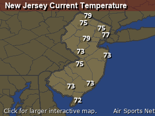
New Jersey's Current Temperatures
 New Jersey's Satellite Image
 New Jersey's Current Wind Direction
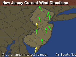
| National Summary |
of upper and lower values of current conditions amongst 6880 locations
in the contiguous United States |
|
High
Temp |
93° |
Scottsdale, Arizona
and 5 other locations
|
|
Low
Temp |
36° |
Yellowstone, Wyoming
|
|
Wind
Speed |
29mph |
Albuquerque, New Mexico
and 1 other location
|
|
Wind
Gust |
43mph |
Springfield, Colorado
|
|
Wind
Chill |
43° |
Pagosa Springs, Colorado
|
|
Heat
Index |
101° |
Baltimore Inner Harbor, Maryland
|
|
High
Pressure |
30.66Hg |
Salida Mountain, Colorado
|
|
Low
Pressure |
29.70Hg |
Thermal, California
|
|
| # Locations Reporting Rain |
61 |
|
| # Locations Reporting Thunderstorms / Lightning |
5 |
|
| # Locations Reporting Fog |
5 |
|
| Average Temperature in the Contiguous USA |
73° |
|
Any use of the information on this page is at your own risk. This information should not be relied upon in life-threatening situations, potential financial loss situations or in lieu of any officially disseminated information. Visit the
National Weather Service for official information.


