Teterboro, New Jersey Weather
No Watches or Warnings for Teterboro
Issued: 6:00 am EDT May 18, 2024 Latitude: 40.8598219 Longitude: -74.0593075 View on Google Maps
|
|
|
|
|
|
|
|
|
|
 |
 |
 |
 |
 |
|
 |
|
| High: °F |
Low: °F |
High: °F |
High: °F |
High: °F |
High: °F |
High: °F |
High: °F |
| Low: °F |
Low: °F |
Low: °F |
Low: °F |
Low: °F |
|
| Rain |
Rain |
Partly Sunny |
Mostly Sunny |
Sunny |
Mostly Sunny |
Thunderstorms |
Mostly Sunny |
Current Conditions at
TETERBORO - (KTEB)
61°
Clear
as of 6:51 AM EDST
Rel. Humidity: 72%
Dew Point: 52°F
Visibility: 10 Miles
Pressure: 29.98 in.
Flight Rule: VFR
Cloud Level(s): Clear
Current Conditions at
CENTRAL PARK NYC - (KNYC)
59°
Clear
as of 6:51 AM EDST
Rel. Humidity: 62%
Dew Point: 46°F
Visibility: 10 Miles
Pressure: 30.01 in.
Flight Rule: VFR
Cloud Level(s): Clear
Current Conditions at
LAGUARDIA NYC - (KLGA)
61°
Mostly Cloudy
as of 6:51 AM EDST
Rel. Humidity: 59%
Dew Point: 46°F
Visibility: 10 Miles
Pressure: 29.98 in.
Flight Rule: VFR
Wind Data
5 MPH
030° Northeast
Cloud Level(s): Scattered at 4000ft, Broken at 15000ft, Broken at 25000ft
Current Conditions at
CALDWELL - (KCDW)
61°
Cloudy
as of 6:53 AM EDST
Rel. Humidity: 82%
Dew Point: 55°F
Visibility: 10 Miles
Pressure: 29.99 in.
Flight Rule: VFR
Cloud Level(s): Solid Overcast at 9000ft
|
Today... A 20 percent chance of showers after 2pm. Mostly cloudy, with a high near 72. Calm wind becoming northeast 5 to 7 mph in the morning. |
|
|
Tonight... A 20 percent chance of showers before 2am. Mostly cloudy, with a low around 58. East wind around 5 mph becoming calm in the evening. |
|
|
Sunday... Partly sunny, with a high near 72. Northeast wind around 7 mph. |
|
 |
Sunday Night... Partly cloudy, with a low around 55. Southeast wind around 6 mph becoming calm in the evening. |
|
|
Monday... Mostly sunny, with a high near 78. Northeast wind around 6 mph becoming southeast in the afternoon. |
|
 |
Monday Night... Mostly clear, with a low around 57. |
|
|
Tuesday... Sunny, with a high near 83. |
|
|
Tuesday Night... Mostly clear, with a low around 60. |
|
|
Wednesday... Mostly sunny, with a high near 85. |
|
|
Wednesday Night... Partly cloudy, with a low around 65. |
|
|
Thursday... A 40 percent chance of showers and thunderstorms. Partly sunny, with a high near 84. |
|
 |
Thursday Night... A 40 percent chance of showers and thunderstorms. Mostly cloudy, with a low around 61. |
|
|
Friday... Mostly sunny, with a high near 78. |
|
Current Radar Image
Sun Almanac for Teterboro, New Jersey
Sunrise: 05:35 AM
Sunset: 8:10 PM
Civil Sunrise:05:04 AM
Civil Sunset: 8:42 PM
Nautical Sunrise: 04:24 AM
Nautical Sunset: 9:21 PM
Astro Sunrise: 03:40 AM
Astro Sunset: 10:05 PM
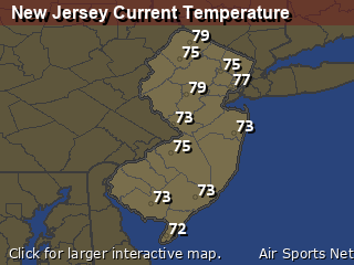
New Jersey's Current Temperatures
 New Jersey's Satellite Image
 New Jersey's Current Wind Direction
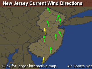
| National Summary |
of upper and lower values of current conditions amongst 7033 locations
in the contiguous United States |
|
High
Temp |
86° |
Key West NAS, Florida
|
|
Low
Temp |
30° |
Afton, Wyoming
and 6 other locations
|
|
Wind
Speed |
33mph |
Plentywood, Montana
|
|
Wind
Gust |
46mph |
Ord, Nebraska
|
|
Wind
Chill |
20° |
Berthoud Pass, Colorado
|
|
Heat
Index |
103° |
Key WestNAS, Florida
|
|
High
Pressure |
30.40Hg |
Pagosa Springs, Colorado
|
|
Low
Pressure |
29.43Hg |
Waskish, Minnesota
|
|
| # Locations Reporting Snow |
1 |
|
| # Locations Reporting Rain |
157 |
|
| # Locations Reporting Thunderstorms / Lightning |
17 |
|
| # Locations Reporting Fog |
118 |
|
| Average Temperature in the Contiguous USA |
60° |
|
Any use of the information on this page is at your own risk. This information should not be relied upon in life-threatening situations, potential financial loss situations or in lieu of any officially disseminated information. Visit the
National Weather Service for official information.


