Sioux Falls, South Dakota Weather
Issued: 3:18 am CST Jan 14, 2026 Latitude: 43.5499749 Longitude: -96.700327 View on Google Maps
|
|
|
|
|
|
|
|
|
|
 |
 |
 |
 |
 |
 |
|
|
| Low: °F |
High: °F |
High: °F |
High: °F |
High: °F |
High: °F |
High: °F |
High: °F |
| Low: °F |
Low: °F |
Low: °F |
Low: °F |
Low: °F |
Low: °F |
|
| Mostly Clear |
Mostly Sunny |
Rain |
Blowing Snow |
Partly Sunny |
Snow |
Mostly Sunny |
Partly Sunny |
Current Conditions at
SIOUX FALLS - (KFSD)
Cloudy
as of 2:56 AM CST
Rel. Humidity: 63%
Dew Point: 18°F
Visibility: 10 Miles
Pressure: 30.09 in.
Flight Rule: VFR
Wind Data
17 MPH
Gust: 26 MPH
350° North
Cloud Level(s): Solid Overcast at 5500ft
Current Conditions at
LUVERNE - (KLYV)
Clear
as of 3:15 AM CST
Rel. Humidity: 63%
Dew Point: 18°F
Visibility: 10 Miles
Pressure: 30.08 in.
Flight Rule: VFR
Wind Data
16 MPH
Gust: 35 MPH
350° North
Cloud Level(s): Clear
Current Conditions at
PIPESTONE - (KPQN)
Clear
as of 3:15 AM CST
Rel. Humidity: 79%
Dew Point: 16°F
Visibility: 10 Miles
Pressure: 30.06 in.
Flight Rule: VFR
Wind Data
17 MPH
Gust: 25 MPH
350° North
Cloud Level(s): Clear
Current Conditions at
SHELDON - (KSHL)
Clear
as of 3:15 AM CST
Rel. Humidity: 79%
Dew Point: 21°F
Visibility: 10 Miles
Pressure: 30.02 in.
Flight Rule: VFR
Wind Data
24 MPH
Gust: 31 MPH
340° North
Cloud Level(s): Clear
|
Overnight... Mostly clear, with a low around 16. Blustery, with a north wind around 20 mph, with gusts as high as 30 mph. |
|
|
Wednesday... Mostly sunny, with a high near 27. Blustery, with a north wind 15 to 20 mph decreasing to 5 to 10 mph in the afternoon. Winds could gust as high as 30 mph. |
|
 |
Wednesday Night... Increasing clouds, with a low around 17. Calm wind becoming south around 5 mph after midnight. |
|
|
Thursday... A 20 percent chance of rain after noon. Partly sunny, with a high near 41. South wind 5 to 15 mph becoming west northwest in the afternoon. Winds could gust as high as 30 mph. |
|
 |
Thursday Night... A slight chance of rain and snow before 9pm, then a chance of snow. Mostly cloudy, with a low around 24. Windy, with a northwest wind 15 to 20 mph increasing to 25 to 30 mph after midnight. Winds could gust as high as 40 mph. Chance of precipitation is 30%. |
|
|
Friday... Snow likely, mainly before noon. Patchy blowing snow before noon. Mostly cloudy, with a high near 29. Windy, with a northwest wind 25 to 30 mph, with gusts as high as 45 mph. Chance of precipitation is 60%. New snow accumulation of less than a half inch possible. |
|
|
Friday Night... Mostly cloudy, with a low around 3. Blustery. |
|
|
Saturday... Partly sunny, with a high near 10. |
|
|
Saturday Night... Mostly cloudy, with a low around -1. |
|
|
Sunday... A 20 percent chance of snow after noon. Partly sunny, with a high near 25. |
|
|
Sunday Night... Mostly cloudy, with a low around 6. |
|
|
M.L.King Day... Mostly sunny, with a high near 19. |
|
 |
Monday Night... Partly cloudy, with a low around 5. |
|
|
Tuesday... Partly sunny, with a high near 23. |
|
Current Radar Image
Sun Almanac for Sioux Falls, South Dakota
Sunrise: 07:57 AM
Sunset: 5:15 PM
Civil Sunrise:07:25 AM
Civil Sunset: 5:47 PM
Nautical Sunrise: 06:50 AM
Nautical Sunset: 6:22 PM
Astro Sunrise: 06:16 AM
Astro Sunset: 6:56 PM
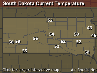
South Dakota's Current Temperatures
 South Dakota's Satellite Image
 South Dakota's Current Wind Direction
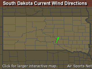
| National Summary |
of upper and lower values of current conditions amongst 7106 locations
in the contiguous United States |
|
High
Temp |
72° |
Stuart/Witham, Florida
and 4 other locations
|
|
Low
Temp |
-4° |
Robertson Field, North Dakota
|
|
Wind
Speed |
33mph |
Berthoud Pass, Colorado
|
|
Wind
Gust |
49mph |
Copper Harbor, Michigan
|
|
Wind
Chill |
-26° |
Grand Marais, Minnesota
|
|
High
Pressure |
30.65Hg |
Stanley Ranger Stn, Idaho
and 1 other location
|
|
Low
Pressure |
29.39Hg |
Alpena, Michigan
and 1 other location
|
|
| # Locations Reporting Snow |
42 |
|
| # Locations Reporting Rain |
60 |
|
| # Locations Reporting Fog |
29 |
|
| Average Temperature in the Contiguous USA |
39° |
|
Any use of the information on this page is at your own risk. This information should not be relied upon in life-threatening situations, potential financial loss situations or in lieu of any officially disseminated information. Visit the
National Weather Service for official information.


