Rapid City, South Dakota Weather
Issued: 10:31 pm MST Jan 19, 2026 Latitude: 44.0805434 Longitude: -103.2310149 View on Google Maps
|
|
|
|
|
|
|
|
|
|
 |
 |
 |
|
 |
|
|
|
| Low: °F |
High: °F |
High: °F |
High: °F |
High: °F |
High: °F |
High: °F |
High: °F |
| Low: °F |
Low: °F |
Low: °F |
Low: °F |
Low: °F |
Low: °F |
|
| Cloudy |
Snow |
Mostly Sunny |
Mostly Sunny |
Snow |
Mostly Sunny |
Mostly Sunny |
Snow |
Current Conditions at
ELLSWORTH AFB - (KRCA)
18°
Clear
as of 9:55 PM MST
Rel. Humidity: 78%
Dew Point: 12°F
Visibility: 10 Miles
Pressure: 30.04 in.
Flight Rule: VFR
Cloud Level(s): Clear
Current Conditions at
RAPID CITY - (KRAP)
18°
Clear
as of 9:52 PM MST
Rel. Humidity: 72%
Dew Point: 10°F
Visibility: 10 Miles
Pressure: 30.08 in.
Flight Rule: VFR
Cloud Level(s): Clear
Current Conditions at
CUSTER - (KCUT)
Clear
as of 9:53 PM MST
Rel. Humidity: 73%
Dew Point: 12°F
Visibility: 10 Miles
Pressure: 29.99 in.
Flight Rule: VFR
Cloud Level(s): Clear
Current Conditions at
PHILIP - (KPHP)
18°
Cloudy
as of 9:55 PM MST
Rel. Humidity: 78%
Dew Point: 12°F
Visibility: 10 Miles
Pressure: 30.13 in.
Flight Rule: VFR
Cloud Level(s): Solid Overcast at 4200ft
|
Tonight... Partly cloudy, with a low around 19. Southwest wind around 5 mph becoming calm in the evening. |
|
|
Tuesday... A 20 percent chance of snow after 11am. Partly sunny, with a high near 44. Wind chill values as low as 15. Breezy, with a southwest wind 6 to 11 mph becoming northwest 20 to 25 mph in the morning. Winds could gust as high as 46 mph. |
|
 |
Tuesday Night... Mostly clear, with a low around 21. Wind chill values as low as 9. Blustery, with a northwest wind 13 to 20 mph, with gusts as high as 34 mph. |
|
|
Wednesday... Mostly sunny, with a temperature rising to near 34 by 11am, then falling to around 22 during the remainder of the day. Wind chill values as low as 10. Breezy, with a northwest wind 16 to 26 mph, with gusts as high as 50 mph. |
|
|
Wednesday Night... Partly cloudy, with a low around 12. Northwest wind 5 to 9 mph, with gusts as high as 22 mph. |
|
|
Thursday... Mostly sunny, with a high near 28. North wind 5 to 14 mph, with gusts as high as 26 mph. |
|
|
Thursday Night... A 20 percent chance of snow after 11pm. Mostly cloudy, with a low around -3. North wind 5 to 7 mph, with gusts as high as 16 mph. |
|
|
Friday... A slight chance of snow. Partly sunny, with a high near 14. East wind 5 to 9 mph, with gusts as high as 18 mph. |
|
|
Friday Night... Partly cloudy, with a low around 0. |
|
|
Saturday... Mostly sunny, with a high near 30. |
|
|
Saturday Night... Partly cloudy, with a low around 10. |
|
|
Sunday... Mostly sunny, with a high near 41. |
|
|
Sunday Night... Partly cloudy, with a low around 20. |
|
|
Monday... A slight chance of snow. Mostly sunny, with a high near 46. |
|
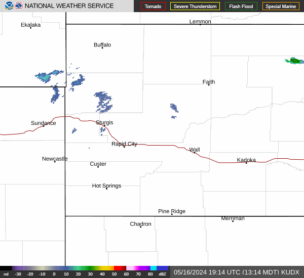
Current Radar Image
Sun Almanac for Rapid City, South Dakota
Sunrise: 07:21 AM
Sunset: 4:47 PM
Civil Sunrise:06:50 AM
Civil Sunset: 5:18 PM
Nautical Sunrise: 06:14 AM
Nautical Sunset: 5:54 PM
Astro Sunrise: 05:40 AM
Astro Sunset: 6:28 PM
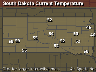
South Dakota's Current Temperatures
 South Dakota's Satellite Image
 South Dakota's Current Wind Direction
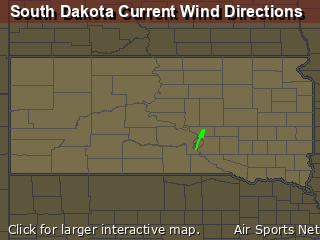
| National Summary |
of upper and lower values of current conditions amongst 6955 locations
in the contiguous United States |
|
High
Temp |
72° |
Riverside, California
|
|
Low
Temp |
-18° |
Hayward, Wisconsin
and 2 other locations
|
|
Wind
Speed |
43mph |
Berthoud Pass, Colorado
|
|
Wind
Gust |
60mph |
Dakota Hill, Colorado
|
|
Wind
Chill |
-31° |
Robertson Field, North Dakota
|
|
High
Pressure |
30.53Hg |
Muskogee, Oklahoma
|
|
Low
Pressure |
29.62Hg |
Frenchville, Maine
|
|
| # Locations Reporting Snow |
44 |
|
| # Locations Reporting Rain |
2 |
|
| # Locations Reporting Fog |
42 |
|
| Average Temperature in the Contiguous USA |
24° |
|
Any use of the information on this page is at your own risk. This information should not be relied upon in life-threatening situations, potential financial loss situations or in lieu of any officially disseminated information. Visit the
National Weather Service for official information.