Newark, New Jersey Weather
Current Conditions at
NEWARK - (KEWR)
Mostly Cloudy
as of 11:51 PM EST
Rel. Humidity: 48%
Dew Point: 1°F
Visibility: 10 Miles
Pressure: 29.93 in.
Flight Rule: VFR
Wind Data
10 MPH
320° Northwest
Cloud Level(s): Broken at 25000ft
Current Conditions at
TETERBORO - (KTEB)
16°
Clear
as of 11:51 PM EST
Rel. Humidity: 52%
Dew Point: 1°F
Visibility: 10 Miles
Pressure: 29.92 in.
Flight Rule: VFR
Wind Data
7 MPH
320° Northwest
Cloud Level(s): Clear
Current Conditions at
CENTRAL PARK NYC - (KNYC)
16°
Clear
as of 11:51 PM EST
Rel. Humidity: 52%
Dew Point: 1°F
Visibility: 10 Miles
Pressure: 29.93 in.
Flight Rule: VFR
Wind Data
5 MPH
Gust: 20 MPH
Cloud Level(s): Clear
Current Conditions at
CALDWELL - (KCDW)
16°
Clear
as of 11:53 PM EST
Rel. Humidity: 47%
Dew Point: -0°F
Visibility: 10 Miles
Pressure: 29.93 in.
Flight Rule: VFR
Wind Data
5 MPH
330° Northwest
Cloud Level(s): Clear
Current Radar Image
Sun Almanac for Newark, New Jersey
Sunrise: 12:05 AM
Sunset: 10:15 PM
Civil Sunrise:11:37 AM
Civil Sunset: 10:44 PM
Nautical Sunrise: 11:04 AM
Nautical Sunset: 11:17 PM
Astro Sunrise: 10:32 AM
Astro Sunset: 11:49 PM
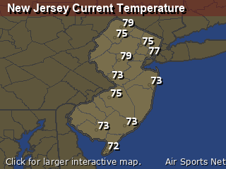
New Jersey's Current Temperatures
 New Jersey's Satellite Image
 New Jersey's Current Wind Direction
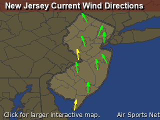
| National Summary |
of upper and lower values of current conditions amongst 6969 locations
in the contiguous United States |
|
High
Temp |
68° |
Phoenix, Arizona
and 1 other location
|
|
Low
Temp |
-17° |
Watertown, New York
|
|
Wind
Speed |
31mph |
Boysen/Thermopol, Wyoming
|
|
Wind
Gust |
40mph |
Dakota Hill, Colorado
|
|
Wind
Chill |
-14° |
Pocono Mnts Municipalcipal Airport, Pennsylvania
and 2 other locations
|
|
High
Pressure |
30.48Hg |
Salida Mountain, Colorado
|
|
Low
Pressure |
29.63Hg |
Bar Harbor, Maine
|
|
| # Locations Reporting Snow |
68 |
|
| # Locations Reporting Rain |
4 |
|
| # Locations Reporting Fog |
9 |
|
| Average Temperature in the Contiguous USA |
28° |
|
Any use of the information on this page is at your own risk. This information should not be relied upon in life-threatening situations, potential financial loss situations or in lieu of any officially disseminated information. Visit the
National Weather Service for official information.


