Grand Forks, North Dakota Weather
No Watches or Warnings for Grand Forks
Issued: 7:36 pm CST Nov 5, 2025 Latitude: 47.9252568 Longitude: -97.0328547 View on Google Maps
|
|
|
|
|
|
|
|
|
|
 |
 |
 |
 |
|
|
|
|
| Low: °F |
High: °F |
High: °F |
High: °F |
High: °F |
High: °F |
High: °F |
High: °F |
| Low: °F |
Low: °F |
Low: °F |
Low: °F |
Low: °F |
Low: °F |
|
| Increasing Clouds |
Rain |
Mostly Sunny |
Partly Sunny |
Mostly Sunny |
Partly Sunny |
Partly Sunny |
Mostly Sunny |
Current Conditions at
GRAND FORKS INTL - (KGFK)
30°
Clear
as of 7:53 PM CST
Rel. Humidity: 80%
Dew Point: 25°F
Visibility: 10 Miles
Pressure: 30.17 in.
Flight Rule: VFR
Wind Data
3 MPH
130° Southeast
Cloud Level(s): Clear
Current Conditions at
GRAND FORKS AFB - (KRDR)
30°
Clear
as of 7:55 PM CST
Rel. Humidity: 80%
Dew Point: 25°F
Visibility: 10 Miles
Pressure: 30.15 in.
Flight Rule: VFR
Wind Data
5 MPH
220° Southwest
Cloud Level(s): Clear
Current Conditions at
CROOKSTON MUNICIPAL FIELD - (KCKN)
34°
Clear
as of 7:55 PM CST
Rel. Humidity: 80%
Dew Point: 28°F
Visibility: 10 Miles
Pressure: 30.19 in.
Flight Rule: VFR
Cloud Level(s): Clear
Current Conditions at
THIEF RIVER FALLS - (KTVF)
28°
Clear
as of 7:56 PM CST
Rel. Humidity: 92%
Dew Point: 27°F
Visibility: 10 Miles
Pressure: 30.19 in.
Flight Rule: VFR
Cloud Level(s): Clear
|
Tonight... Increasing clouds, with a temperature falling to near 26 by 10pm, then rising to around 33 during the remainder of the night. Light southeast wind increasing to 5 to 10 mph after midnight. |
|
|
Thursday... A 20 percent chance of rain after noon. Mostly cloudy, with a high near 48. Southeast wind 6 to 14 mph becoming southwest in the afternoon. |
|
|
Thursday Night... Increasing clouds, with a low around 30. West wind 6 to 13 mph becoming north after midnight. |
|
|
Friday... Cloudy, then gradually becoming mostly sunny, with a high near 35. North wind 10 to 16 mph, with gusts as high as 26 mph. |
|
|
Friday Night... Mostly cloudy, with a low around 18. North wind 5 to 8 mph. |
|
|
Saturday... Partly sunny, with a high near 29. North wind 7 to 15 mph. |
|
 |
Saturday Night... Partly cloudy, with a low around 17. Northwest wind around 11 mph. |
|
|
Sunday... Mostly sunny, with a high near 31. North northwest wind 10 to 15 mph. |
|
|
Sunday Night... Partly cloudy, with a low around 16. North northwest wind 6 to 8 mph becoming southwest after midnight. |
|
|
Monday... Partly sunny, with a high near 36. South wind 6 to 13 mph. |
|
|
Monday Night... Mostly cloudy, with a low around 27. South wind 10 to 14 mph. |
|
|
Veterans Day... Partly sunny, with a high near 46. Southwest wind 13 to 17 mph becoming northwest in the afternoon. Winds could gust as high as 28 mph. |
|
|
Tuesday Night... Mostly cloudy, with a low around 29. West northwest wind around 11 mph. |
|
|
Wednesday... Mostly sunny, with a high near 44. West northwest wind 9 to 15 mph. |
|
Current Radar Image
Sun Almanac for Grand Forks, North Dakota
Sunrise: 07:20 AM
Sunset: 5:03 PM
Civil Sunrise:06:47 AM
Civil Sunset: 5:36 PM
Nautical Sunrise: 06:10 AM
Nautical Sunset: 6:13 PM
Astro Sunrise: 05:34 AM
Astro Sunset: 6:49 PM
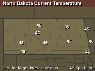
North Dakota's Current Temperatures
 North Dakota's Satellite Image
 North Dakota's Current Wind Direction
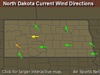
| National Summary |
of upper and lower values of current conditions amongst 6904 locations
in the contiguous United States |
|
High
Temp |
82° |
Bullhead City, Arizona
|
|
Low
Temp |
25° |
Rolla Municipal A/P, North Dakota
and 1 other location
|
|
Wind
Speed |
35mph |
Altoona, Pennsylvania
|
|
Wind
Gust |
55mph |
Altoona, Pennsylvania
|
|
Wind
Chill |
22° |
Pagosa Springs, Colorado
|
|
High
Pressure |
30.60Hg |
Salida Mountain, Colorado
|
|
Low
Pressure |
29.45Hg |
Portsmouth, New Hampshire
|
|
| # Locations Reporting Snow |
1 |
|
| # Locations Reporting Rain |
106 |
|
| # Locations Reporting Fog |
3 |
|
| Average Temperature in the Contiguous USA |
53° |
|
Any use of the information on this page is at your own risk. This information should not be relied upon in life-threatening situations, potential financial loss situations or in lieu of any officially disseminated information. Visit the
National Weather Service for official information.


