Fargo, North Dakota Weather
Issued: 2:18 pm CST Jan 21, 2026 Latitude: 46.8771863 Longitude: -96.7898034 View on Google Maps
|
|
|
|
|
|
|
|
|
|
 |
|
 |
 |
|
 |
|
|
| High: °F |
Low: °F |
High: °F |
High: °F |
High: °F |
High: °F |
High: °F |
High: °F |
| Low: °F |
Low: °F |
Low: °F |
Low: °F |
Low: °F |
|
| Snow |
Snow |
Partly Sunny |
Sunny |
Partly Sunny |
Mostly Sunny |
Mostly Sunny |
Partly Sunny |
Current Conditions at
FARGO - (KFAR)
Cloudy
Light Snow Blowing Snow
as of 2:14 PM CST
Rel. Humidity: 72%
Dew Point: 9°F
Visibility: 1 1/2 Miles
Pressure: 29.92 in.
Flight Rule: IFR
Wind Data
18 MPH
Gust: 28 MPH
310° Northwest
Cloud Level(s): Few at 1400ft, Broken at 3000ft, Solid Overcast at 5500ft
Current Conditions at
MOORHEAD - (KJKJ)
Cloudy
as of 1:55 PM CST
Rel. Humidity: 72%
Dew Point: 9°F
Visibility: 10 Miles
Pressure: 29.92 in.
Flight Rule: VFR
Wind Data
18 MPH
330° Northwest
Cloud Level(s): Solid Overcast at 5000ft
Current Conditions at
DETROIT LAKES - (KDTL)
Cloudy
Light Snow
as of 1:55 PM CST
Rel. Humidity: 92%
Dew Point: 9°F
Visibility: 7 Miles
Pressure: 29.82 in.
Flight Rule: IFR
Wind Data
21 MPH
Gust: 28 MPH
320° Northwest
Cloud Level(s): Broken at 600ft, Broken at 2100ft, Solid Overcast at 4700ft
Current Conditions at
WAHPETON - (KBWP)
Mostly Cloudy
Light Snow Mist
as of 1:55 PM CST
Rel. Humidity: 100%
Dew Point: 16°F
Visibility: 1/2 Miles
Pressure: 29.92 in.
Flight Rule: IFR
Wind Data
22 MPH
Gust: 33 MPH
330° Northwest
Cloud Level(s): Scattered at 300ft, Scattered at 1500ft, Broken at 2400ft
|
This Afternoon... A 20 percent chance of snow before 5pm. Mostly cloudy, with a steady temperature around 13. Blustery, with a northwest wind 17 to 24 mph, with gusts as high as 37 mph. |
|
|
Tonight... A slight chance of snow between 8pm and 4am. Mostly cloudy, with a low around -11. Wind chill values as low as -21. West northwest wind 10 to 16 mph. Chance of precipitation is 20%. |
|
|
Thursday... Partly sunny, with a temperature falling to around -13 by 5pm. Wind chill values as low as -38. Blustery, with a north northwest wind 15 to 21 mph, with gusts as high as 31 mph. |
|
 |
Thursday Night... Partly cloudy, with a low around -23. Wind chill values as low as -45. West northwest wind 9 to 16 mph. |
|
|
Friday... Sunny and cold, with a high near -11. West northwest wind 5 to 9 mph. |
|
|
Friday Night... Partly cloudy, with a low around -22. Light and variable wind becoming south around 6 mph after midnight. |
|
|
Saturday... Partly sunny and cold, with a high near -5. South wind 6 to 8 mph. |
|
 |
Saturday Night... Mostly cloudy, with a low around -20. South southeast wind around 7 mph. |
|
|
Sunday... Mostly sunny, with a high near -2. West wind 7 to 10 mph. |
|
|
Sunday Night... Partly cloudy, with a low around -12. South southwest wind around 9 mph. |
|
|
Monday... Mostly sunny, with a high near 13. West southwest wind 8 to 10 mph. |
|
|
Monday Night... Partly cloudy, with a low around -2. West wind around 7 mph. |
|
|
Tuesday... Partly sunny, with a high near 14. West wind 7 to 9 mph. |
|
Current Radar Image
Sun Almanac for Fargo, North Dakota
Sunrise: 08:03 AM
Sunset: 5:14 PM
Civil Sunrise:07:30 AM
Civil Sunset: 5:47 PM
Nautical Sunrise: 06:52 AM
Nautical Sunset: 6:25 PM
Astro Sunrise: 06:16 AM
Astro Sunset: 7:01 PM
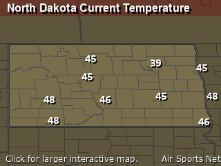
North Dakota's Current Temperatures
 North Dakota's Satellite Image
 North Dakota's Current Wind Direction
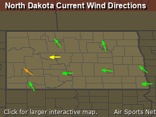
| National Summary |
of upper and lower values of current conditions amongst 7010 locations
in the contiguous United States |
|
High
Temp |
79° |
Ft Myers Sw Airportt, Florida
and 1 other location
|
|
Low
Temp |
5° |
Cavalier Municipal A/P, North Dakota
and 4 other locations
|
|
Wind
Speed |
48mph |
Tekamah, Nebraska
|
|
Wind
Gust |
71mph |
Tekamah, Nebraska
|
|
Wind
Chill |
-17° |
Rolla Municipal A/P, North Dakota
|
|
High
Pressure |
30.70Hg |
Charlie, Montana
|
|
Low
Pressure |
29.53Hg |
Grand Marais, Minnesota
|
|
| # Locations Reporting Snow |
189 |
|
| # Locations Reporting Rain |
60 |
|
| # Locations Reporting Fog |
15 |
|
| Average Temperature in the Contiguous USA |
43° |
|
Any use of the information on this page is at your own risk. This information should not be relied upon in life-threatening situations, potential financial loss situations or in lieu of any officially disseminated information. Visit the
National Weather Service for official information.


