Bismarck, North Dakota Weather
Current Conditions at
BISMARCK - (KBIS)
32°
Mostly Clear
Fog
as of 5:52 AM CST
Rel. Humidity: 100%
Dew Point: 32°F
Visibility: 1/2 Miles
Pressure: 29.97 in.
Flight Rule: IFR
Current Conditions at
GARRISON - (KN60)
30°
Cloudy
as of 5:54 AM CST
Rel. Humidity: 100%
Dew Point: 30°F
Pressure: 29.95 in.
Current Conditions at
MOBRIDGE - (KMBG)
25°
Clear
as of 5:52 AM CST
Rel. Humidity: 92%
Dew Point: 23°F
Visibility: 10 Miles
Pressure: 29.97 in.
Flight Rule: VFR
Cloud Level(s): Clear
Current Conditions at
DICKINSON - (KDIK)
Clear
as of 4:56 AM MST
Rel. Humidity: 64%
Dew Point: 27°F
Visibility: 10 Miles
Pressure: 29.90 in.
Flight Rule: VFR
Cloud Level(s): Clear
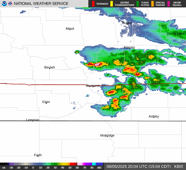
Current Radar Image
Sun Almanac for Bismarck, North Dakota
Sunrise: 13:57 AM
Sunset: 11:57 PM
Civil Sunrise:13:26 AM
Civil Sunset: 00:29 PM
Nautical Sunrise: 12:50 AM
Nautical Sunset: 01:05 PM
Astro Sunrise: 12:15 AM
Astro Sunset: 01:40 PM
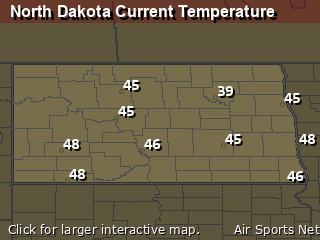
North Dakota's Current Temperatures
 North Dakota's Satellite Image
 North Dakota's Current Wind Direction
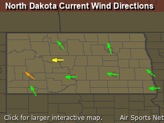
| National Summary |
of upper and lower values of current conditions amongst 7068 locations
in the contiguous United States |
|
High
Temp |
72° |
Keathley C 875, Louisiana
|
|
Low
Temp |
-35° |
Watertown, New York
|
|
Wind
Speed |
31mph |
Pocono Mnts Municipalcipal Airport, Pennsylvania
|
|
Wind
Gust |
41mph |
Pocono Mnts Municipalcipal Airport, Pennsylvania
|
|
Wind
Chill |
-34° |
Pocono Mnts Municipalcipal Airport, Pennsylvania
|
|
High
Pressure |
30.52Hg |
Salida Mountain, Colorado
|
|
Low
Pressure |
29.73Hg |
Charlie, Montana
|
|
| # Locations Reporting Snow |
32 |
|
| # Locations Reporting Rain |
27 |
|
| # Locations Reporting Fog |
40 |
|
| Average Temperature in the Contiguous USA |
28° |
|
Any use of the information on this page is at your own risk. This information should not be relied upon in life-threatening situations, potential financial loss situations or in lieu of any officially disseminated information. Visit the
National Weather Service for official information.