Wymberly, Georgia Weather
|
|
|
|
|
|
|
|
 |
 |
 |
|
 |
 |
|
 |
| Low: °F |
High: °F |
High: °F |
High: °F |
High: °F |
High: °F |
High: °F |
High: °F |
| Low: °F |
Low: °F |
Low: °F |
Low: °F |
Low: °F |
Low: °F |
|
| Thunderstorms |
Thunderstorms |
Thunderstorms |
Thunderstorms |
Thunderstorms |
Thunderstorms |
Thunderstorms |
Thunderstorms |
Current Conditions at
HUNTER AFB - (KSVN)
79°
Cloudy
as of 8:30 PM EDST
Rel. Humidity: 83%
Dew Point: 73°F
Visibility: 10 Miles
Pressure: 29.91 in.
Flight Rule: VFR
Cloud Level(s): Few at 4700ft, Broken at 5500ft, Solid Overcast at 8500ft
Current Conditions at
SAVANNAH - (KSAV)
81°
Clear
as of 7:53 PM EDST
Rel. Humidity: 74%
Dew Point: 72°F
Visibility: 10 Miles
Pressure: 29.95 in.
Flight Rule: VFR
Wind Data
13 MPH
010° North
Cloud Level(s): Few at 3000ft, Broken at 6000ft, Broken at 9000ft, Broken at 20000ft
Current Conditions at
HILTON HEAD - (KHXD)
77°
Cloudy
as of 7:50 PM EDST
Rel. Humidity: 88%
Dew Point: 73°F
Visibility: 10 Miles
Pressure: 29.93 in.
Flight Rule: VFR
Wind Data
14 MPH
Gust: 21 MPH
030° Northeast
Cloud Level(s): Solid Overcast at 10000ft
Current Conditions at
FORT STEWART - (KLHW)
81°
Clear
as of 7:55 PM EDST
Rel. Humidity: 69%
Dew Point: 70°F
Visibility: 10 Miles
Pressure: 29.92 in.
Flight Rule: VFR
Cloud Level(s): Clear
|
Tonight... A 40 percent chance of showers and thunderstorms, mainly before 1am. Partly cloudy, with a low around 74. Northwest wind 6 to 10 mph. |
|
|
Sunday... A 30 percent chance of showers and thunderstorms, mainly after 4pm. Mostly sunny, with a high near 89. West wind 7 to 9 mph. |
|
 |
Sunday Night... A 30 percent chance of showers and thunderstorms, mainly before 8pm. Partly cloudy, with a low around 76. Southwest wind 5 to 7 mph. |
|
|
Monday... A 20 percent chance of showers and thunderstorms after 2pm. Mostly sunny, with a high near 93. Heat index values as high as 103. South wind 6 to 9 mph. |
|
 |
Monday Night... Partly cloudy, with a low around 78. South wind 6 to 8 mph. |
|
|
Tuesday... A 20 percent chance of showers and thunderstorms after 2pm. Mostly sunny, with a high near 94. |
|
 |
Tuesday Night... Mostly cloudy, with a low around 77. |
|
|
Wednesday... A 40 percent chance of showers and thunderstorms after 2pm. Mostly sunny, with a high near 92. |
|
 |
Wednesday Night... A 30 percent chance of showers and thunderstorms before 2am. Mostly cloudy, with a low around 76. |
|
|
Thursday... A 50 percent chance of showers and thunderstorms, mainly after 2pm. Partly sunny, with a high near 91. |
|
|
Thursday Night... A 30 percent chance of showers and thunderstorms. Mostly cloudy, with a low around 77. |
|
|
Friday... A 50 percent chance of showers and thunderstorms. Partly sunny, with a high near 91. |
|
|
Friday Night... A 30 percent chance of showers and thunderstorms. Mostly cloudy, with a low around 75. |
|
|
Saturday... A 40 percent chance of showers and thunderstorms. Partly sunny, with a high near 91. |
|
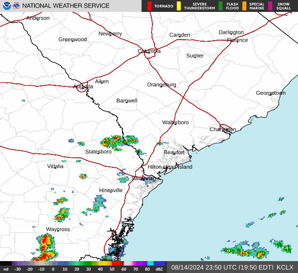
Current Radar Image
Sun Almanac for Wymberly, Georgia
Sunrise: 06:24 AM
Sunset: 8:34 PM
Civil Sunrise:05:56 AM
Civil Sunset: 9:02 PM
Nautical Sunrise: 05:22 AM
Nautical Sunset: 9:36 PM
Astro Sunrise: 04:45 AM
Astro Sunset: 10:13 PM
Georgia's Current Temperatures
 Georgia's Satellite Image
 Georgia's Current Wind Direction
| National Summary |
of upper and lower values of current conditions amongst 6915 locations
in the contiguous United States |
|
High
Temp |
111° |
Palm Springs, California
|
|
Low
Temp |
50° |
West Yellowstone, Montana
|
|
Wind
Speed |
29mph |
Powell, Wyoming
|
|
Wind
Gust |
43mph |
Gillette, Wyoming
|
|
High
Pressure |
30.77Hg |
Salida Mountain, Colorado
|
|
Low
Pressure |
29.77Hg |
Munising, Michigan
|
|
| # Locations Reporting Rain |
87 |
|
| # Locations Reporting Thunderstorms / Lightning |
12 |
|
| # Locations Reporting Fog |
3 |
|
| Average Temperature in the Contiguous USA |
82° |
|
Any use of the information on this page is at your own risk. This information should not be relied upon in life-threatening situations, potential financial loss situations or in lieu of any officially disseminated information. Visit the
National Weather Service for official information.