West Acres Development, South Dakota Weather
Current Conditions at
SIOUX FALLS - (KFSD)
Cloudy
Light Drizzle
as of 2:56 PM CDST
Rel. Humidity: 86%
Dew Point: 32°F
Visibility: 10 Miles
Pressure: 29.66 in.
Flight Rule: MVFR
Wind Data
16 MPH
020° North
Cloud Level(s): Solid Overcast at 1100ft
Current Conditions at
LUVERNE - (KLYV)
34°
Cloudy
as of 2:55 PM CDST
Rel. Humidity: 93%
Dew Point: 32°F
Visibility: 10 Miles
Pressure: 29.66 in.
Flight Rule: MVFR
Cloud Level(s): Solid Overcast at 1000ft
Current Conditions at
PIPESTONE - (KPQN)
Cloudy
as of 2:55 PM CDST
Rel. Humidity: 100%
Dew Point: 32°F
Visibility: 7 Miles
Pressure: 29.64 in.
Flight Rule: IFR
Wind Data
14 MPH
030° Northeast
Cloud Level(s): Solid Overcast at 700ft
Current Conditions at
YANKTON - (KYKN)
Cloudy
as of 2:56 PM CDST
Rel. Humidity: 86%
Dew Point: 34°F
Visibility: 10 Miles
Pressure: 29.70 in.
Flight Rule: MVFR
Wind Data
12 MPH
340° North
Cloud Level(s): Solid Overcast at 1200ft
Moon Almanac for West Acres Development, South Dakota
Moon Phase: Full Moon
Moon Illumination: 99%
Moon Age: 15.4 Days
Moon is currently below the horizon
Distance from Moon to Earth: 246,874 miles
Upcoming Lunar Events for
West Acres Development: |
| Next Event | Event Time | Illum |
|
|
|
| Moonrise: | 09:59 pm Thu | 99.0% |
| High Moon: | 03:17 am Fri | 98.5% |
| Moonset: | 08:25 am Fri | 98.0% |
 | New Moon: Wed Mar 18 |
 | First Quarter: Wed Mar 25 |
 | Full Moon: Wed Apr 1 |
 | Last Quarter: Fri Apr 10 |
| New Moon: Fri Apr 17 |
Current Radar Image
| South Dakota State Summary |
of upper and lower values of current conditions amongst 20 locations
in South Dakota |
|
|
|
Low
Temp |
30° |
Sisseton
and 1 other location
|
|
|
|
Wind
Gust |
20mph |
Pine Ridge
|
|
Wind
Chill |
21° |
Sisseton
and 1 other location
|
|
High
Pressure |
29.77Hg |
Aberdeen
|
|
Low
Pressure |
29.55Hg |
Spearfish/Clyde Ice
|
|
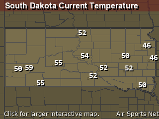
| Average temperature in South Dakota |
38° |
|
# Locations Reporting VFR
(Visual Flight Rules) |
20 |
|
South Dakota's Current Temperatures
 South Dakota's Satellite Image
 South Dakota's Current Wind Direction
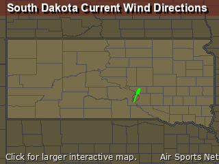
| National Summary |
of upper and lower values of current conditions amongst 5097 locations
in the contiguous United States |
|
High
Temp |
93° |
Zapata Cnty A/P, Texas
and 1 other location
|
|
Low
Temp |
25° |
Mullan Pass, Idaho
|
|
Wind
Speed |
37mph |
Edgar County Arpt, Illinois
|
|
Wind
Gust |
47mph |
Edgar County Arpt, Illinois
|
|
Wind
Chill |
13° |
Evanston, Wyoming
and 1 other location
|
|
Heat
Index |
94° |
Falfurrias, Texas
|
|
High
Pressure |
30.61Hg |
Portland, Maine
|
|
Low
Pressure |
29.44Hg |
Powell, Wyoming
|
|
| # Locations Reporting Snow |
59 |
|
| # Locations Reporting Rain |
94 |
|
| # Locations Reporting Thunderstorms / Lightning |
4 |
|
| # Locations Reporting Fog |
11 |
|
| Average Temperature in the Contiguous USA |
60° |
|
Any use of the information on this page is at your own risk. This information should not be relied upon in life-threatening situations, potential financial loss situations or in lieu of any officially disseminated information. Visit the
National Weather Service for official information.


