Waterwitch, New Jersey Weather
| New Jersey State Summary |
of upper and lower values of current conditions amongst 1 locations
in New Jersey |
|
|
|
|
|
Wind
Speed |
13mph |
Pittstown
|
|
|
|
|
|
High
Pressure |
29.89Hg |
Pittstown
|
|
Low
Pressure |
29.89Hg |
Pittstown
|
|
| Average temperature in New Jersey |
34° |
|
# Locations Reporting VFR
(Visual Flight Rules) |
1 |
|
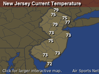
New Jersey's Current Temperatures
 New Jersey's Satellite Image
 New Jersey's Current Wind Direction
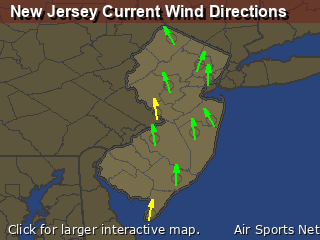
| National Summary |
of upper and lower values of current conditions amongst 5336 locations
in the contiguous United States |
|
High
Temp |
86° |
Borrego Springs, California
|
|
Low
Temp |
7° |
Dodge Center, Minnesota
|
|
Wind
Speed |
40mph |
Big Timber, Montana
|
|
Wind
Gust |
60mph |
Berthoud Pass, Colorado
|
|
Wind
Chill |
-11° |
Robertson Field, North Dakota
|
|
High
Pressure |
30.44Hg |
Vidalia/Concordi, Louisiana
|
|
Low
Pressure |
29.35Hg |
Presque Isle, Maine
|
|
| # Locations Reporting Snow |
95 |
|
| # Locations Reporting Rain |
12 |
|
| # Locations Reporting Fog |
3 |
|
| Average Temperature in the Contiguous USA |
36° |
|
Any use of the information on this page is at your own risk. This information should not be relied upon in life-threatening situations, potential financial loss situations or in lieu of any officially disseminated information. Visit the
National Weather Service for official information.


