Sheldon Junction, Vermont Weather
Current Conditions at
ST JOHNSBURY - (K1V4)
34°
Clear
as of 2:54 AM EDST
Rel. Humidity: 80%
Dew Point: 28°F
Pressure: 30.31 in.
Moon Almanac for Sheldon Junction, Vermont
Moon Phase: Full Moon
Moon Illumination: 98%
Moon Age: 15.9 Days
Moon is currently above the horizon
Distance from Moon to Earth: 247,907 miles
Upcoming Lunar Events for
Sheldon Junction: |
| Next Event | Event Time | Illum |
|
|
|
| Moonset: | 06:45 am Fri | 98.2% |
| Moonrise: | 09:30 pm Fri | 96.2% |
| High Moon: | 02:23 am Sat | 95.4% |
| Moonset: | 07:07 am Sat | 94.5% |
 | New Moon: Wed Mar 18 |
 | First Quarter: Wed Mar 25 |
 | Full Moon: Wed Apr 1 |
 | Last Quarter: Fri Apr 10 |
| New Moon: Fri Apr 17 |
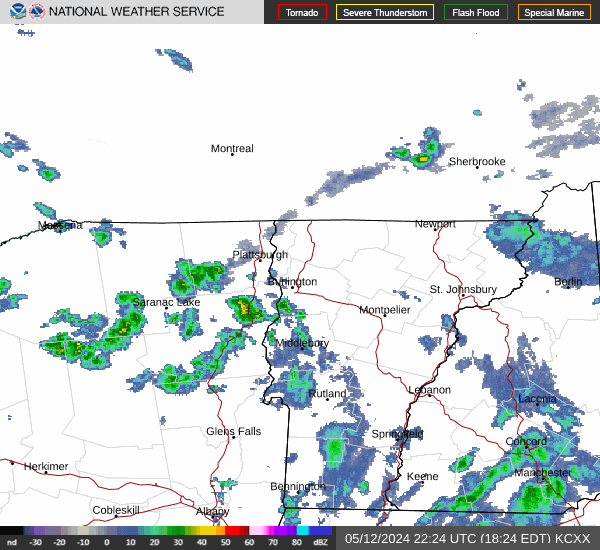
Current Radar Image
| Vermont State Summary |
of upper and lower values of current conditions amongst 1 locations
in Vermont |
|
High
Temp |
34° |
St Johnsbury
|
|
|
|
High
Pressure |
30.31Hg |
St Johnsbury
|
|
Low
Pressure |
30.31Hg |
St Johnsbury
|
|
| Average temperature in Vermont |
34° |
|
# Locations Reporting VFR
(Visual Flight Rules) |
1 |
|
Vermont's Current Temperatures
 Vermont's Satellite Image
 Vermont's Current Wind Direction
| National Summary |
of upper and lower values of current conditions amongst 2938 locations
in the contiguous United States |
|
High
Temp |
79° |
Key West Intl, Florida
|
|
Low
Temp |
21° |
Yellowstone, Wyoming
and 1 other location
|
|
Wind
Speed |
43mph |
Lima Madis, Colorado
|
|
Wind
Gust |
49mph |
Lima Madis, Colorado
and 1 other location
|
|
Wind
Chill |
15° |
Charlie, Montana
|
|
High
Pressure |
30.46Hg |
Portsmouth, New Hampshire
|
|
Low
Pressure |
29.62Hg |
Grayling Aaf Airpor, Michigan
|
|
| # Locations Reporting Snow |
12 |
|
| # Locations Reporting Rain |
7 |
|
| # Locations Reporting Thunderstorms / Lightning |
1 |
|
| # Locations Reporting Fog |
2 |
|
| Average Temperature in the Contiguous USA |
54° |
|
Any use of the information on this page is at your own risk. This information should not be relied upon in life-threatening situations, potential financial loss situations or in lieu of any officially disseminated information. Visit the
National Weather Service for official information.