No Watches or Warnings for Rayville
Issued: 12:48 am EST Dec 15, 2025 Latitude: 44.1031265 Longitude: -70.5536706 View on Google Maps
|
|
|
|
|
|
|
|
|
|
 |
 |
 |
 |
|
 |
|
 |
| Low: °F |
High: °F |
High: °F |
High: °F |
High: °F |
High: °F |
High: °F |
High: °F |
| Low: °F |
Low: °F |
Low: °F |
Low: °F |
Low: °F |
Low: °F |
|
| Mostly Clear |
Increasing Clouds |
Sunny |
Partly Sunny |
Partly Sunny |
Rain |
Partly Sunny |
Snow |
Current Conditions at
AUBURN/LWSTN - (KLEW)
Clear
as of 12:56 AM EST
Rel. Humidity: 61%
Dew Point: 1°F
Visibility: 10 Miles
Pressure: 29.88 in.
Flight Rule: VFR
Wind Data
13 MPH
320° Northwest
Cloud Level(s): Clear
Current Conditions at
FRYEBURG - (KIZG)
-2°
Clear
as of 12:54 AM EST
Rel. Humidity: 77%
Dew Point: -8°F
Visibility: 10 Miles
Pressure: 29.90 in.
Flight Rule: VFR
Cloud Level(s): Clear
Current Conditions at
PORTLAND - (KPWM)
Clear
as of 12:51 AM EST
Rel. Humidity: 56%
Dew Point: 1°F
Visibility: 10 Miles
Pressure: 29.91 in.
Flight Rule: VFR
Wind Data
14 MPH
330° Northwest
Cloud Level(s): Clear
Current Conditions at
AUGUSTA - (KAUG)
Clear
as of 12:53 AM EST
Rel. Humidity: 56%
Dew Point: -0°F
Visibility: 10 Miles
Pressure: 29.85 in.
Flight Rule: VFR
Wind Data
9 MPH
300° Northwest
Cloud Level(s): Clear
|
Overnight... Mostly clear, with a low around 7. Wind chill values as low as -9. Northwest wind around 15 mph, with gusts as high as 25 mph. |
|
|
Monday... Increasing clouds, with a high near 18. Wind chill values as low as -8. Northwest wind 10 to 15 mph, with gusts as high as 30 mph. |
|
 |
Monday Night... Mostly cloudy, with a low around 8. West wind around 5 mph becoming calm after midnight. |
|
|
Tuesday... Sunny, with a high near 27. Calm wind becoming southwest around 5 mph in the afternoon. |
|
|
Tuesday Night... Mostly cloudy, with a low around 16. South wind 5 to 10 mph. |
|
|
Wednesday... Partly sunny, with a high near 36. |
|
 |
Wednesday Night... Partly cloudy, with a low around 17. |
|
|
Thursday... Partly sunny, with a high near 39. |
|
 |
Thursday Night... Scattered showers before 1am, then rain, mainly after 1am. Low around 33. Chance of precipitation is 90%. |
|
|
Friday... Rain likely before 9am, then scattered showers between 9am and 3pm. Partly sunny, with a high near 45. Chance of precipitation is 60%. |
|
|
Friday Night... Partly cloudy, with a low around 10. |
|
|
Saturday... Partly sunny, with a high near 26. |
|
 |
Saturday Night... Scattered snow showers. Mostly cloudy, with a low around 20. Chance of precipitation is 40%. |
|
|
Sunday... Scattered snow showers. Partly sunny, with a high near 36. Chance of precipitation is 30%. |
|
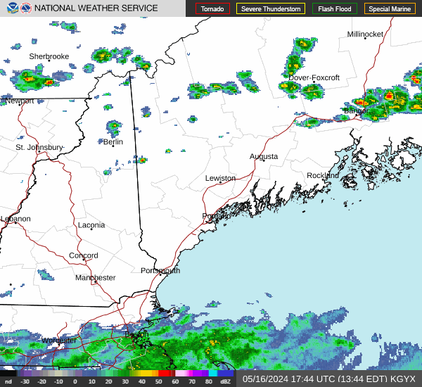
Current Radar Image
Sun Almanac for Rayville, Maine
Sunrise: 07:11 AM
Sunset: 4:04 PM
Civil Sunrise:06:38 AM
Civil Sunset: 4:38 PM
Nautical Sunrise: 06:01 AM
Nautical Sunset: 5:14 PM
Astro Sunrise: 05:26 AM
Astro Sunset: 5:49 PM
Maine's Current Temperatures
 Maine's Satellite Image
 Maine's Current Wind Direction
| National Summary |
of upper and lower values of current conditions amongst 7009 locations
in the contiguous United States |
|
High
Temp |
73° |
Key West NAS, Florida
and 1 other location
|
|
Low
Temp |
-9° |
Terre Haute, Indiana
and 4 other locations
|
|
Wind
Speed |
36mph |
Tracy, Minnesota
|
|
Wind
Gust |
48mph |
Tracy, Minnesota
|
|
Wind
Chill |
-27° |
Bloomington, Illinois
|
|
High
Pressure |
30.65Hg |
Little Rock Adams Fld, Arkansas
and 2 other locations
|
|
Low
Pressure |
29.73Hg |
Greenville, Maine
and 1 other location
|
|
| # Locations Reporting Snow |
52 |
|
| # Locations Reporting Rain |
4 |
|
| # Locations Reporting Fog |
25 |
|
| Average Temperature in the Contiguous USA |
25° |
|
Any use of the information on this page is at your own risk. This information should not be relied upon in life-threatening situations, potential financial loss situations or in lieu of any officially disseminated information. Visit the
National Weather Service for official information.