Port Emma, North Dakota Weather
Current Conditions at
ABERDEEN - (KABR)
Cloudy
as of 2:53 AM CDST
Rel. Humidity: 92%
Dew Point: 27°F
Visibility: 8 Miles
Pressure: 30.05 in.
Flight Rule: MVFR
Wind Data
9 MPH
310° Northwest
Cloud Level(s): Solid Overcast at 1100ft
Current Conditions at
SISSETON - (K8D3)
30°
Clear
as of 2:56 AM CDST
Rel. Humidity: 100%
Dew Point: 30°F
Pressure: 30.00 in.
Current Conditions at
JAMESTOWN - (KJMS)
Cloudy
Light Snow
as of 2:56 AM CDST
Rel. Humidity: 100%
Dew Point: 30°F
Visibility: 9 Miles
Pressure: 30.06 in.
Flight Rule: IFR
Wind Data
10 MPH
340° North
Cloud Level(s): Solid Overcast at 700ft
Current Conditions at
WAHPETON - (KBWP)
30°
Cloudy
Light Snow Mist
as of 2:55 AM CDST
Rel. Humidity: 100%
Dew Point: 30°F
Visibility: 3/4 Miles
Pressure: 30.01 in.
Flight Rule: LIFR
Cloud Level(s): Solid Overcast at 300ft
Moon Almanac for Port Emma, North Dakota
Moon Phase: Waning Gibbous
Moon Illumination: 95%
Moon Age: 16.8 Days
Moon is currently above the horizon
Distance from Moon to Earth: 249,785 miles
Upcoming Lunar Events for
Port Emma: |
| Next Event | Event Time | Illum |
|
|
|
| Moonset: | 08:46 am Sat | 94.2% |
| Moonrise: | 12:28 am Sun | 90.9% |
| High Moon: | 04:54 am Sun | 89.9% |
| Moonset: | 09:12 am Sun | 88.8% |
 | New Moon: Wed Mar 18 |
 | First Quarter: Wed Mar 25 |
 | Full Moon: Wed Apr 1 |
 | Last Quarter: Fri Apr 10 |
| New Moon: Fri Apr 17 |
Current Radar Image
| North Dakota State Summary |
of upper and lower values of current conditions amongst 27 locations
in North Dakota |
|
High
Temp |
34° |
Grand Forks AFB
and 3 other locations
|
|
Low
Temp |
27° |
Hettinger
and 1 other location
|
|
Wind
Speed |
16mph |
Cooperstown
|
|
|
|
High
Pressure |
30.24Hg |
Watford City Municipal
|
|
Low
Pressure |
30.01Hg |
Wahpeton
|
|
| Average temperature in North Dakota |
30° |
|
| # Locations Reporting Snow |
12 |
|
# Locations Reporting IFR
(Instrument Flight Rules) |
5 |
|
# Locations Reporting MVFR
(Marginal Visual Flight Rules) |
4 |
|
# Locations Reporting VFR
(Visual Flight Rules) |
18 |
|
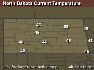
North Dakota's Current Temperatures
 North Dakota's Satellite Image
 North Dakota's Current Wind Direction
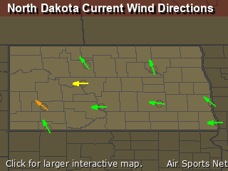
| National Summary |
of upper and lower values of current conditions amongst 6315 locations
in the contiguous United States |
|
High
Temp |
79° |
Key West Intl, Florida
and 2 other locations
|
|
Low
Temp |
10° |
Berthoud Pass, Colorado
|
|
Wind
Speed |
44mph |
Wichita Falls, Texas
|
|
Wind
Gust |
58mph |
Wichita Falls, Texas
|
|
Wind
Chill |
-12° |
Berthoud Pass, Colorado
|
|
High
Pressure |
30.45Hg |
Salida Mountain, Colorado
|
|
Low
Pressure |
29.82Hg |
Burlington, Iowa
and 1 other location
|
|
| # Locations Reporting Snow |
73 |
|
| # Locations Reporting Rain |
154 |
|
| # Locations Reporting Thunderstorms / Lightning |
23 |
|
| # Locations Reporting Fog |
12 |
|
| Average Temperature in the Contiguous USA |
52° |
|
Any use of the information on this page is at your own risk. This information should not be relied upon in life-threatening situations, potential financial loss situations or in lieu of any officially disseminated information. Visit the
National Weather Service for official information.


