Plattford, Nebraska Weather
Current Conditions at
OMAHA/MILLARD AP - (KMLE)
48°
Cloudy
as of 6:55 PM CDST
Rel. Humidity: 36%
Dew Point: 23°F
Visibility: 10 Miles
Pressure: 30.29 in.
Flight Rule: VFR
Wind Data
7 MPH
140° Southeast
Cloud Level(s): Solid Overcast at 12000ft
Current Conditions at
OFFUTT AFB - (KOFF)
50°
Cloudy
as of 6:55 PM CDST
Rel. Humidity: 31%
Dew Point: 21°F
Visibility: 10 Miles
Pressure: 30.28 in.
Flight Rule: VFR
Wind Data
8 MPH
130° Southeast
Cloud Level(s): Broken at 12000ft, Solid Overcast at 20000ft
Current Conditions at
OMAHA - (KOMA)
Cloudy
as of 6:52 PM CDST
Rel. Humidity: 34%
Dew Point: 21°F
Visibility: 10 Miles
Pressure: 30.29 in.
Flight Rule: VFR
Wind Data
12 MPH
170° South
Cloud Level(s): Scattered at 8000ft, Broken at 13000ft, Solid Overcast at 25000ft
Current Conditions at
COUNCIL BLUFFS - (KCBF)
48°
Partly Cloudy
as of 6:55 PM CDST
Rel. Humidity: 34%
Dew Point: 21°F
Visibility: 10 Miles
Pressure: 30.28 in.
Flight Rule: VFR
Cloud Level(s): Scattered at 8000ft, Scattered at 12000ft
Moon Almanac for Plattford, Nebraska
Moon Phase: Waxing Crescent
Moon Illumination: 30%
Moon Age: 5.44 Days
Moon is currently above the horizon
Distance from Moon to Earth: 225,757 miles
Upcoming Lunar Events for
Plattford: |
| Next Event | Event Time | Illum |
|
|
|
| Moonset: | 02:51 am Tue | 32.8% |
| Moonrise: | 11:36 am Tue | 36.8% |
| High Moon: | 07:46 pm Tue | 40.7% |
| Moonset: | 03:58 am Wed | 44.6% |
 | New Moon: Wed Mar 18 |
 | First Quarter: Wed Mar 25 |
 | Full Moon: Wed Apr 1 |
 | Last Quarter: Fri Apr 10 |
| New Moon: Fri Apr 17 |
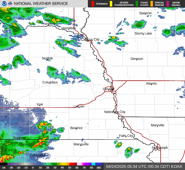
Current Radar Image
| Nebraska State Summary |
of upper and lower values of current conditions amongst 39 locations
in Nebraska |
|
|
|
Low
Temp |
46° |
Fremont Municipalcipal Arpt
and 1 other location
|
|
|
|
Wind
Gust |
30mph |
Sidney
and 1 other location
|
|
Wind
Chill |
41° |
Fremont Municipalcipal Arpt
and 1 other location
|
|
High
Pressure |
30.30Hg |
Falls City
|
|
Low
Pressure |
29.95Hg |
Scottsbluff
and 1 other location
|
|
| Average temperature in Nebraska |
53° |
|
# Locations Reporting VFR
(Visual Flight Rules) |
39 |
|
Nebraska's Current Temperatures
 Nebraska's Satellite Image
 Nebraska's Current Wind Direction
| National Summary |
of upper and lower values of current conditions amongst 6810 locations
in the contiguous United States |
|
High
Temp |
99° |
Gila Bend (Aaf), Arizona
and 4 other locations
|
|
Low
Temp |
21° |
Munising, Michigan
|
|
Wind
Speed |
40mph |
Salida Mountain, Colorado
|
|
Wind
Gust |
49mph |
Salida Mountain, Colorado
|
|
Wind
Chill |
12° |
Berthoud Pass, Colorado
|
|
High
Pressure |
30.47Hg |
Salida Mountain, Colorado
|
|
Low
Pressure |
29.78Hg |
Nellis AFB, Nevada
and 3 other locations
|
|
| # Locations Reporting Snow |
36 |
|
| # Locations Reporting Rain |
11 |
|
| # Locations Reporting Fog |
1 |
|
| Average Temperature in the Contiguous USA |
57° |
|
Any use of the information on this page is at your own risk. This information should not be relied upon in life-threatening situations, potential financial loss situations or in lieu of any officially disseminated information. Visit the
National Weather Service for official information.