No Watches or Warnings for Parnell
Issued: 5:06 am CST Dec 17, 2025 Latitude: 32.6948521 Longitude: -86.9147112 View on Google Maps
|
|
|
|
|
|
|
|
|
|
 |
 |
 |
 |
|
|
|
|
| High: °F |
Low: °F |
High: °F |
High: °F |
High: °F |
High: °F |
High: °F |
High: °F |
| Low: °F |
Low: °F |
Low: °F |
Low: °F |
Low: °F |
|
| Partly Sunny |
Rain |
Thunderstorms |
Sunny |
Sunny |
Partly Sunny |
Partly Sunny |
Partly Sunny |
Current Conditions at
CALERA - (KEET)
30°
Clear
as of 4:53 AM CST
Rel. Humidity: 86%
Dew Point: 27°F
Visibility: 10 Miles
Pressure: 30.20 in.
Flight Rule: VFR
Cloud Level(s): Clear
Current Conditions at
MAXWELL AFB - (KMXF)
37°
Clear
as of 4:55 AM CST
Rel. Humidity: 74%
Dew Point: 30°F
Visibility: 10 Miles
Pressure: 30.19 in.
Flight Rule: VFR
Cloud Level(s): Clear
Current Conditions at
MONTGOMERY - (KMGM)
32°
Clear
as of 4:53 AM CST
Rel. Humidity: 80%
Dew Point: 27°F
Visibility: 10 Miles
Pressure: 30.22 in.
Flight Rule: VFR
Cloud Level(s): Clear
Current Conditions at
TUSCALOOSA - (KTCL)
30°
Clear
as of 4:53 AM CST
Rel. Humidity: 92%
Dew Point: 28°F
Visibility: 9 Miles
Pressure: 30.21 in.
Flight Rule: VFR
Cloud Level(s): Clear
|
Today... Partly sunny, with a high near 61. Calm wind. |
|
|
Tonight... A 30 percent chance of showers, mainly after 3am. Mostly cloudy, with a low around 44. Calm wind. |
|
|
Thursday... Rain before 1pm, then showers between 1pm and 3pm, then showers and possibly a thunderstorm after 3pm. High near 64. Southeast wind around 5 mph. Chance of precipitation is 90%. New rainfall amounts between a quarter and half of an inch possible. |
|
 |
Thursday Night... Showers before midnight. Low around 37. South wind around 5 mph becoming northwest after midnight. Chance of precipitation is 80%. |
|
|
Friday... Sunny, with a high near 54. Northwest wind around 5 mph becoming calm in the afternoon. |
|
 |
Friday Night... Mostly clear, with a low around 31. |
|
|
Saturday... Sunny, with a high near 62. |
|
 |
Saturday Night... Partly cloudy, with a low around 44. |
|
|
Sunday... A 20 percent chance of showers. Partly sunny, with a high near 66. |
|
 |
Sunday Night... A 20 percent chance of showers. Mostly cloudy, with a low around 49. |
|
|
Monday... Partly sunny, with a high near 66. |
|
 |
Monday Night... Mostly cloudy, with a low around 47. |
|
|
Tuesday... Partly sunny, with a high near 67. |
|
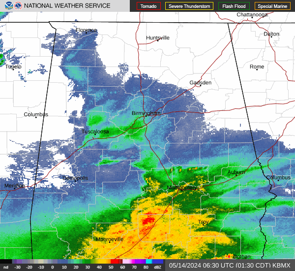
Current Radar Image
Sun Almanac for Parnell, Alabama
Sunrise: 06:44 AM
Sunset: 4:44 PM
Civil Sunrise:06:17 AM
Civil Sunset: 5:11 PM
Nautical Sunrise: 05:46 AM
Nautical Sunset: 5:42 PM
Astro Sunrise: 05:16 AM
Astro Sunset: 6:12 PM
Alabama's Current Temperatures
 Alabama's Satellite Image
 Alabama's Current Wind Direction
| National Summary |
of upper and lower values of current conditions amongst 6428 locations
in the contiguous United States |
|
High
Temp |
75° |
Keathley C 875, Louisiana
|
|
Low
Temp |
1° |
Gunnison, Colorado
|
|
Wind
Speed |
43mph |
Livingston, Montana
|
|
Wind
Gust |
59mph |
Livingston, Montana
|
|
Wind
Chill |
-9° |
Robertson Field, North Dakota
|
|
High
Pressure |
30.38Hg |
Salida Mountain, Colorado
|
|
Low
Pressure |
29.17Hg |
Ephrata, Washington
|
|
| # Locations Reporting Rain |
92 |
|
| # Locations Reporting Fog |
37 |
|
| Average Temperature in the Contiguous USA |
38° |
|
Any use of the information on this page is at your own risk. This information should not be relied upon in life-threatening situations, potential financial loss situations or in lieu of any officially disseminated information. Visit the
National Weather Service for official information.