Norman, North Dakota Weather
| North Dakota State Summary |
of upper and lower values of current conditions amongst 28 locations
in North Dakota |
|
High
Temp |
34° |
Grand Forks Intl
and 5 other locations
|
|
Low
Temp |
28° |
Mandan Municipal
and 4 other locations
|
|
Wind
Speed |
16mph |
Mandan Municipal
|
|
Wind
Chill |
16° |
Mandan Municipal
|
|
High
Pressure |
30.25Hg |
Watford City Municipal
|
|
Low
Pressure |
30.04Hg |
Wahpeton
|
|
| Average temperature in North Dakota |
31° |
|
| # Locations Reporting Snow |
11 |
|
| # Locations Reporting Rain |
1 |
|
# Locations Reporting IFR
(Instrument Flight Rules) |
5 |
|
# Locations Reporting MVFR
(Marginal Visual Flight Rules) |
5 |
|
# Locations Reporting VFR
(Visual Flight Rules) |
18 |
|
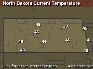
North Dakota's Current Temperatures
 North Dakota's Satellite Image
 North Dakota's Current Wind Direction
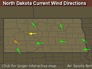
| National Summary |
of upper and lower values of current conditions amongst 6232 locations
in the contiguous United States |
|
High
Temp |
79° |
Key West Intl, Florida
and 2 other locations
|
|
Low
Temp |
12° |
Pagosa Springs, Colorado
and 2 other locations
|
|
Wind
Speed |
68mph |
Bellefontaine, Ohio
|
|
Wind
Gust |
56mph |
Wichita Falls, Texas
|
|
Wind
Chill |
-10° |
Berthoud Pass, Colorado
|
|
High
Pressure |
30.45Hg |
Salida Mountain, Colorado
|
|
Low
Pressure |
29.82Hg |
Cedar Rapids, Iowa
|
|
| # Locations Reporting Snow |
71 |
|
| # Locations Reporting Rain |
134 |
|
| # Locations Reporting Thunderstorms / Lightning |
22 |
|
| # Locations Reporting Fog |
4 |
|
| Average Temperature in the Contiguous USA |
53° |
|
Any use of the information on this page is at your own risk. This information should not be relied upon in life-threatening situations, potential financial loss situations or in lieu of any officially disseminated information. Visit the
National Weather Service for official information.


