Nag Creek, Rhode Island Weather
No Watches or Warnings for Nag Creek
Issued: 2:22 am EDT Jun 4, 2025 Latitude: 41.6492684 Longitude: -71.3289405 View on Google Maps
|
|
|
|
|
|
|
|
 |
 |
 |
 |
 |
 |
|
|
|
|
|
|
| Mostly Sunny |
Cloudy |
Thunderstorms |
Thunderstorms |
Rain |
Rain |
Current Conditions at
KINGSTON - (KOQU)
59°
Cloudy
Drizzle Haze
as of 4:15 AM EDST
Rel. Humidity: 72%
Dew Point: 50°F
Visibility: 1/4 Miles
Pressure: 30.18 in.
Flight Rule: IFR
Wind Data
6 MPH
210° Southwest
Cloud Level(s): Solid Overcast at 7000ft
Current Conditions at
PROVIDENCE - (KPVD)
57°
Clear
as of 3:51 AM EDST
Rel. Humidity: 62%
Dew Point: 45°F
Visibility: 10 Miles
Pressure: 30.19 in.
Flight Rule: VFR
Cloud Level(s): Clear
Current Conditions at
NEWPORT - (KUUU)
59°
Clear
as of 3:53 AM EDST
Rel. Humidity: 62%
Dew Point: 46°F
Visibility: 10 Miles
Pressure: 30.19 in.
Flight Rule: VFR
Cloud Level(s): Clear
Current Conditions at
WESTERLY STATE ARPT - (KWST)
52°
Clear
as of 3:53 AM EDST
Rel. Humidity: 87%
Dew Point: 48°F
Visibility: 10 Miles
Pressure: 30.20 in.
Flight Rule: VFR
Cloud Level(s): Clear
|
Wednesday... SSW wind 5 to 8 kt increasing to 8 to 11 kt in the afternoon. Mostly sunny. Seas 1 to 2 ft. |
|
|
Wednesday Night... SSW wind 6 to 9 kt. Partly cloudy. Seas around 1 ft. |
|
|
Thursday... SSW wind 5 to 9 kt. A slight chance of showers and thunderstorms after 4pm. Seas 1 to 2 ft. |
|
 |
Thursday Night... SW wind 6 to 9 kt. A slight chance of showers and thunderstorms before 7pm. Seas 1 to 2 ft. |
|
|
Friday... W wind 5 to 9 kt becoming SSW in the afternoon. A slight chance of showers and thunderstorms before 1pm, then a chance of showers between 1pm and 4pm, then a chance of showers and thunderstorms after 4pm. Seas around 1 ft. |
|
 |
Friday Night... SSW wind around 9 kt. A chance of showers. Seas around 1 ft. |
|
|
Saturday... S wind around 9 kt. Showers likely, mainly after 1pm. The rain could be heavy at times. Seas around 1 ft. |
|
 |
Saturday Night... S wind around 9 kt becoming SW after midnight. Showers likely. Seas around 1 ft. |
|
|
Sunday... NNW wind around 9 kt becoming SSW in the afternoon. A chance of showers. Seas around 1 ft. |
|
Current Radar Image
Sun Almanac for Nag Creek, Rhode Island
Sunrise: 05:12 AM
Sunset: 8:15 PM
Civil Sunrise:04:38 AM
Civil Sunset: 8:49 PM
Nautical Sunrise: 03:56 AM
Nautical Sunset: 9:32 PM
Astro Sunrise: 03:05 AM
Astro Sunset: 10:23 PM
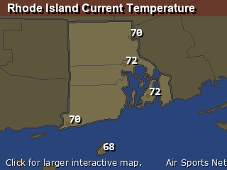
Rhode Island's Current Temperatures
 Rhode Island's Satellite Image
 Rhode Island's Current Wind Direction
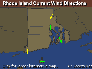
| National Summary |
of upper and lower values of current conditions amongst 6999 locations
in the contiguous United States |
|
High
Temp |
84° |
Phoenix, Arizona
and 5 other locations
|
|
Low
Temp |
32° |
Pinedale, Wyoming
and 1 other location
|
|
Wind
Speed |
25mph |
Travis AFB, California
|
|
Wind
Gust |
32mph |
Byron, California
and 1 other location
|
|
Wind
Chill |
23° |
Pagosa Springs, Colorado
|
|
High
Pressure |
30.43Hg |
Salida Mountain, Colorado
|
|
Low
Pressure |
29.28Hg |
Eagle Range, Utah
|
|
| # Locations Reporting Snow |
1 |
|
| # Locations Reporting Rain |
126 |
|
| # Locations Reporting Thunderstorms / Lightning |
5 |
|
| # Locations Reporting Fog |
20 |
|
| Average Temperature in the Contiguous USA |
61° |
|
Any use of the information on this page is at your own risk. This information should not be relied upon in life-threatening situations, potential financial loss situations or in lieu of any officially disseminated information. Visit the
National Weather Service for official information.


