No Watches or Warnings for Midway
Issued: 8:15 pm EDT May 5, 2024 Latitude: 30.8265813 Longitude: -84.1785104 View on Google Maps
|
|
|
|
|
|
|
|
|
|
 |
 |
 |
|
 |
 |
 |
|
| Low: °F |
High: °F |
High: °F |
High: °F |
High: °F |
High: °F |
High: °F |
High: °F |
| Low: °F |
Low: °F |
Low: °F |
Low: °F |
Low: °F |
Low: °F |
|
| Mostly Clear |
Thunderstorms |
Mostly Sunny |
Mostly Sunny |
Thunderstorms |
Thunderstorms |
Sunny |
Thunderstorms |
Current Conditions at
MOULTRIE - (KMGR)
81°
Mostly Clear
as of 8:15 PM EDST
Rel. Humidity: 74%
Dew Point: 72°F
Visibility: 9 Miles
Pressure: 30.01 in.
Flight Rule: VFR
Cloud Level(s): Few at 5500ft
Current Conditions at
BAINBRIDGE - (KBGE)
81°
Partly Cloudy
as of 8:15 PM EDST
Rel. Humidity: 69%
Dew Point: 70°F
Visibility: 10 Miles
Pressure: 30.02 in.
Flight Rule: VFR
Wind Data
8 MPH
230° Southwest
Cloud Level(s): Scattered at 5000ft, Scattered at 12000ft
Current Conditions at
TALLAHASSEE - (KTLH)
82°
Partly Cloudy
as of 7:53 PM EDST
Rel. Humidity: 65%
Dew Point: 70°F
Visibility: 10 Miles
Pressure: 30.01 in.
Flight Rule: VFR
Cloud Level(s): Few at 6000ft, Scattered at 10000ft, Scattered at 25000ft
Current Conditions at
ALBANY - (KABY)
84°
Clear
as of 7:53 PM EDST
Rel. Humidity: 51%
Dew Point: 64°F
Visibility: 10 Miles
Pressure: 30.01 in.
Flight Rule: VFR
Wind Data
3 MPH
220° Southwest
Cloud Level(s): Clear
|
Tonight... Mostly clear, with a low around 67. South wind around 5 mph becoming calm in the evening. |
|
|
Monday... A 30 percent chance of showers and thunderstorms, mainly after 2pm. Mostly sunny, with a high near 88. Calm wind becoming south southwest around 5 mph in the afternoon. |
|
|
Monday Night... Mostly clear, with a low around 67. South wind around 5 mph becoming calm after midnight. |
|
|
Tuesday... Mostly sunny, with a high near 89. South southwest wind 5 to 10 mph. |
|
 |
Tuesday Night... Partly cloudy, with a low around 69. South southwest wind around 5 mph. |
|
|
Wednesday... Mostly sunny, with a high near 91. |
|
|
Wednesday Night... Mostly clear, with a low around 70. |
|
|
Thursday... A 20 percent chance of showers and thunderstorms after 2pm. Mostly sunny, with a high near 91. |
|
 |
Thursday Night... A slight chance of showers and thunderstorms before 8pm, then a slight chance of showers and thunderstorms after 2am. Partly cloudy, with a low around 72. Chance of precipitation is 20%. |
|
|
Friday... Showers and thunderstorms likely, mainly after 2pm. Partly sunny, with a high near 86. Breezy. Chance of precipitation is 60%. |
|
 |
Friday Night... Showers and thunderstorms likely. Mostly clear, with a low around 60. Chance of precipitation is 60%. |
|
|
Saturday... Sunny, with a high near 79. |
|
|
Saturday Night... Partly cloudy, with a low around 57. |
|
|
Sunday... A 20 percent chance of showers and thunderstorms. Mostly sunny, with a high near 80. |
|
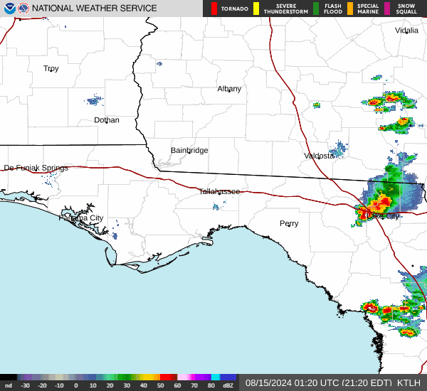
Current Radar Image
Sun Almanac for Midway, Georgia
Sunrise: 06:48 AM
Sunset: 8:18 PM
Civil Sunrise:06:23 AM
Civil Sunset: 8:44 PM
Nautical Sunrise: 05:52 AM
Nautical Sunset: 9:15 PM
Astro Sunrise: 05:19 AM
Astro Sunset: 9:48 PM
Georgia's Current Temperatures
 Georgia's Satellite Image
 Georgia's Current Wind Direction
| National Summary |
of upper and lower values of current conditions amongst 6917 locations
in the contiguous United States |
|
High
Temp |
91° |
Presidio, Texas
|
|
Low
Temp |
32° |
Pagosa Springs, Colorado
|
|
Wind
Speed |
44mph |
La / Whiteman, California
|
|
Wind
Gust |
63mph |
Winslow, Arizona
|
|
Wind
Chill |
19° |
Pagosa Springs, Colorado
|
|
Heat
Index |
95° |
Mcallen, Texas
|
|
High
Pressure |
30.82Hg |
Ottawa, Ohio
|
|
Low
Pressure |
29.36Hg |
Worland, Wyoming
|
|
| # Locations Reporting Snow |
9 |
|
| # Locations Reporting Rain |
174 |
|
| # Locations Reporting Thunderstorms / Lightning |
9 |
|
| # Locations Reporting Fog |
6 |
|
| Average Temperature in the Contiguous USA |
66° |
|
Any use of the information on this page is at your own risk. This information should not be relied upon in life-threatening situations, potential financial loss situations or in lieu of any officially disseminated information. Visit the
National Weather Service for official information.