No Watches or Warnings for McGinty
Issued: 11:31 pm CST Dec 17, 2025 Latitude: 32.7773531 Longitude: -85.1521619 View on Google Maps
|
|
|
|
|
|
|
|
|
|
 |
 |
 |
|
 |
|
|
|
| Low: °F |
High: °F |
High: °F |
High: °F |
High: °F |
High: °F |
High: °F |
High: °F |
| Low: °F |
Low: °F |
Low: °F |
Low: °F |
Low: °F |
Low: °F |
|
| Rain |
Thunderstorms |
Sunny |
Sunny |
Mostly Sunny |
Sunny |
Mostly Sunny |
Mostly Sunny |
Current Conditions at
LA GRANGE - (KLGC)
45°
Clear
as of 1:35 AM EST
Rel. Humidity: 93%
Dew Point: 43°F
Visibility: 10 Miles
Pressure: 30.08 in.
Flight Rule: VFR
Cloud Level(s): Clear
Current Conditions at
AUBURN - (KAUO)
55°
Clear
as of 11:56 PM CST
Rel. Humidity: 87%
Dew Point: 52°F
Visibility: 10 Miles
Pressure: 30.07 in.
Flight Rule: VFR
Cloud Level(s): Clear
Current Conditions at
COLUMBUS - (KCSG)
54°
Clear
as of 12:51 AM EST
Rel. Humidity: 81%
Dew Point: 48°F
Visibility: 10 Miles
Pressure: 30.08 in.
Flight Rule: VFR
Cloud Level(s): Clear
Current Conditions at
LAWSON AFB - (KLSF)
48°
Partly Cloudy
as of 12:55 AM EST
Rel. Humidity: 93%
Dew Point: 46°F
Visibility: 10 Miles
Pressure: 30.05 in.
Flight Rule: VFR
Cloud Level(s): Scattered at 15000ft
|
Overnight... A 20 percent chance of rain after 3am. Cloudy, with a low around 45. Southeast wind around 5 mph. |
|
|
Thursday... Rain, mainly between 9am and 3pm, then showers likely and possibly a thunderstorm after 3pm. High near 61. South wind 5 to 10 mph. Chance of precipitation is 90%. New rainfall amounts between a tenth and quarter of an inch, except higher amounts possible in thunderstorms. |
|
 |
Thursday Night... Showers and possibly a thunderstorm before midnight, then a slight chance of rain between midnight and 3am. Low around 41. South wind around 10 mph becoming northwest after midnight. Winds could gust as high as 20 mph. Chance of precipitation is 80%. New precipitation amounts between a tenth and quarter of an inch, except higher amounts possible in thunderstorms. |
|
|
Friday... Sunny, with a high near 55. Northwest wind 5 to 10 mph. |
|
 |
Friday Night... Mostly clear, with a low around 31. Northwest wind around 5 mph becoming calm in the evening. |
|
|
Saturday... Sunny, with a high near 60. |
|
 |
Saturday Night... Partly cloudy, with a low around 40. |
|
|
Sunday... Mostly sunny, with a high near 64. |
|
|
Sunday Night... Mostly clear, with a low around 39. |
|
|
Monday... Sunny, with a high near 58. |
|
|
Monday Night... Partly cloudy, with a low around 38. |
|
|
Tuesday... Mostly sunny, with a high near 62. |
|
|
Tuesday Night... Mostly clear, with a low around 44. |
|
|
Wednesday... Mostly sunny, with a high near 70. |
|
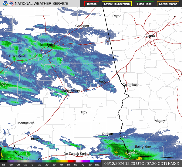
Current Radar Image
Sun Almanac for McGinty, Alabama
Sunrise: 06:38 AM
Sunset: 4:37 PM
Civil Sunrise:06:10 AM
Civil Sunset: 5:04 PM
Nautical Sunrise: 05:40 AM
Nautical Sunset: 5:35 PM
Astro Sunrise: 05:09 AM
Astro Sunset: 6:05 PM
Alabama's Current Temperatures
 Alabama's Satellite Image
 Alabama's Current Wind Direction
| National Summary |
of upper and lower values of current conditions amongst 7104 locations
in the contiguous United States |
|
High
Temp |
79° |
Keathley C 875, Louisiana
|
|
Low
Temp |
3° |
Glasgow, Montana
|
|
Wind
Speed |
61mph |
Buffalo, South Dakota
|
|
Wind
Gust |
96mph |
Buffalo, South Dakota
|
|
Wind
Chill |
-24° |
Glasgow, Montana
|
|
High
Pressure |
30.25Hg |
Lehighton, Pennsylvania
and 4 other locations
|
|
Low
Pressure |
29.02Hg |
Fosston, Minnesota
and 2 other locations
|
|
| # Locations Reporting Snow |
25 |
|
| # Locations Reporting Rain |
57 |
|
| # Locations Reporting Fog |
29 |
|
| Average Temperature in the Contiguous USA |
44° |
|
Any use of the information on this page is at your own risk. This information should not be relied upon in life-threatening situations, potential financial loss situations or in lieu of any officially disseminated information. Visit the
National Weather Service for official information.