Manchester, New Mexico Weather
Current Conditions at
RUIDOSO - (KSRR)
Cloudy
as of 5:15 PM MDST
Rel. Humidity: 44%
Dew Point: 21°F
Visibility: 10 Miles
Pressure: 30.56 in.
Flight Rule: MVFR
Wind Data
18 MPH
140° Southeast
Cloud Level(s): Solid Overcast at 2800ft
Current Conditions at
HOLLOMAN AFB - (KHMN)
77°
Mostly Clear
as of 4:55 PM MDST
Rel. Humidity: 17%
Dew Point: 30°F
Visibility: 10 Miles
Pressure: 30.27 in.
Flight Rule: VFR
Wind Data
20 MPH
020° North
Cloud Level(s): Few at 15000ft
Current Conditions at
ARTESIA - (KATS)
55°
Cloudy
as of 5:15 PM MDST
Rel. Humidity: 26%
Dew Point: 21°F
Visibility: 10 Miles
Pressure: 30.52 in.
Flight Rule: VFR
Wind Data
24 MPH
030° Northeast
Cloud Level(s): Solid Overcast at 5000ft
Moon Almanac for Manchester, New Mexico
Moon Phase: Waxing Gibbous
Moon Illumination: 73%
Moon Age: 9.68 Days
Moon is currently above the horizon
Distance from Moon to Earth: 230,776 miles
Upcoming Lunar Events for
Manchester: |
| Next Event | Event Time | Illum |
|
|
|
| High Moon: | 11:23 pm Fri | 75.0% |
| Moonset: | 06:33 am Sat | 77.8% |
| Moonrise: | 05:13 pm Sat | 81.7% |
| High Moon: | 12:14 am Sun | 84.1% |
| Moonset: | 07:06 am Sun | 86.3% |
 | New Moon: Wed Mar 18 |
 | First Quarter: Wed Mar 25 |
 | Full Moon: Wed Apr 1 |
 | Last Quarter: Fri Apr 10 |
| New Moon: Fri Apr 17 |
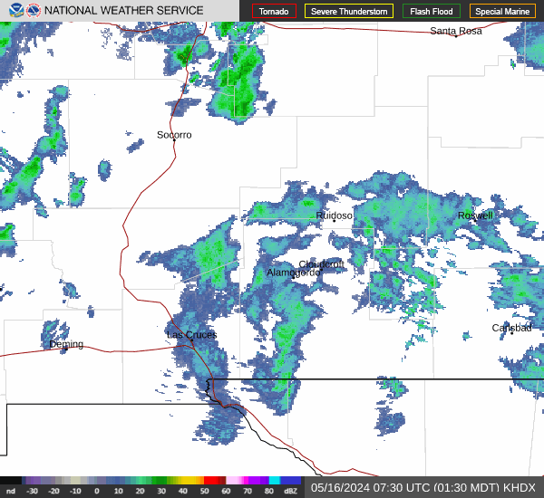
Current Radar Image
| New Mexico State Summary |
of upper and lower values of current conditions amongst 32 locations
in New Mexico |
|
High
Temp |
79° |
Lordsburg
and 1 other location
|
|
|
|
|
|
Wind
Gust |
38mph |
Clines Corners
and 1 other location
|
|
|
|
High
Pressure |
30.57Hg |
Clayton
|
|
Low
Pressure |
30.19Hg |
Lordsburg
|
|
| Average temperature in New Mexico |
60° |
|
# Locations Reporting VFR
(Visual Flight Rules) |
32 |
|
New Mexico's Current Temperatures
 New Mexico's Satellite Image
 New Mexico's Current Wind Direction
| National Summary |
of upper and lower values of current conditions amongst 6838 locations
in the contiguous United States |
|
High
Temp |
102° |
Laguna (Aaf), Arizona
|
|
Low
Temp |
10° |
Frenchville, Maine
|
|
Wind
Speed |
32mph |
Marfa, Texas
and 1 other location
|
|
Wind
Gust |
43mph |
Hobart, Oklahoma
|
|
Wind
Chill |
-7° |
Frenchville, Maine
|
|
High
Pressure |
30.67Hg |
Granite Falls, Minnesota
|
|
Low
Pressure |
29.76Hg |
Thermal, California
|
|
| # Locations Reporting Snow |
11 |
|
| # Locations Reporting Rain |
52 |
|
| # Locations Reporting Fog |
1 |
|
| Average Temperature in the Contiguous USA |
56° |
|
Any use of the information on this page is at your own risk. This information should not be relied upon in life-threatening situations, potential financial loss situations or in lieu of any officially disseminated information. Visit the
National Weather Service for official information.