Johnson City, New York Weather
No Watches or Warnings for Johnson City
Issued: 3:22 pm EST Dec 21, 2025 Latitude: 42.1156308 Longitude: -75.9588092 View on Google Maps
|
|
|
|
|
|
|
|
|
|
 |
|
 |
 |
|
 |
 |
 |
| High: °F |
Low: °F |
High: °F |
High: °F |
High: °F |
High: °F |
High: °F |
High: °F |
| Low: °F |
Low: °F |
Low: °F |
Low: °F |
Low: °F |
|
| Flurries |
Flurries |
Increasing Clouds |
Snow |
Mostly Cloudy |
Rain & Snow |
Rain |
Rain & Snow |
Current Conditions at
BINGHAMTON - (KBGM)
Cloudy
as of 2:53 PM EST
Rel. Humidity: 49%
Dew Point: 9°F
Visibility: 10 Miles
Pressure: 30.15 in.
Flight Rule: VFR
Wind Data
10 MPH
Gust: 36 MPH
310° Northwest
Cloud Level(s): Broken at 4100ft, Solid Overcast at 4900ft
Current Conditions at
ITHACA - (KITH)
Cloudy
as of 2:56 PM EST
Rel. Humidity: 53%
Dew Point: 12°F
Visibility: 10 Miles
Pressure: 30.21 in.
Flight Rule: VFR
Wind Data
21 MPH
Gust: 29 MPH
280° West
Cloud Level(s): Solid Overcast at 4200ft
Current Conditions at
ELMIRA - (KELM)
Partly Cloudy
as of 2:53 PM EST
Rel. Humidity: 45%
Dew Point: 9°F
Visibility: 10 Miles
Pressure: 30.24 in.
Flight Rule: VFR
Wind Data
18 MPH
Gust: 28 MPH
320° Northwest
Cloud Level(s): Scattered at 4600ft
Current Conditions at
SCRANTON - (KAVP)
Mostly Clear
as of 2:54 PM EST
Rel. Humidity: 43%
Dew Point: 12°F
Visibility: 10 Miles
Pressure: 30.18 in.
Flight Rule: VFR
Wind Data
18 MPH
Gust: 28 MPH
330° Northwest
Cloud Level(s): Few at 6000ft
|
This Afternoon... Scattered flurries. Partly sunny, with a high near 34. West wind around 11 mph, with gusts as high as 24 mph. |
|
|
Tonight... Scattered flurries before 1am. Mostly cloudy, with a low around 18. West wind 6 to 8 mph. |
|
|
Monday... Increasing clouds, with a high near 36. West wind 3 to 6 mph. |
|
 |
Monday Night... Snow showers, mainly after 1am. Low around 27. Calm wind becoming south around 5 mph after midnight. Chance of precipitation is 80%. New snow accumulation of around an inch possible. |
|
|
Tuesday... Snow showers, possibly mixed with rain before 4pm, then a chance of rain showers. High near 40. South wind around 6 mph. Chance of precipitation is 90%. |
|
|
Tuesday Night... A chance of rain showers before 1am, then a chance of rain and snow showers between 1am and 4am, then a chance of snow showers after 4am. Mostly cloudy, with a low around 30. Chance of precipitation is 40%. |
|
|
Wednesday... Mostly cloudy, with a high near 36. |
|
 |
Wednesday Night... A chance of snow showers after 1am. Mostly cloudy, with a low around 26. Chance of precipitation is 30%. |
|
|
Christmas Day... A chance of rain and snow showers before 1pm, then a chance of rain showers. Partly sunny, with a high near 42. Chance of precipitation is 30%. |
|
 |
Thursday Night... A chance of showers. Cloudy, with a low around 34. Chance of precipitation is 50%. |
|
|
Friday... Showers likely. Cloudy, with a high near 48. Chance of precipitation is 70%. |
|
 |
Friday Night... Rain and snow showers likely. Mostly cloudy, with a low around 28. Chance of precipitation is 60%. |
|
|
Saturday... A chance of rain and snow showers. Mostly cloudy, with a high near 40. Chance of precipitation is 40%. |
|
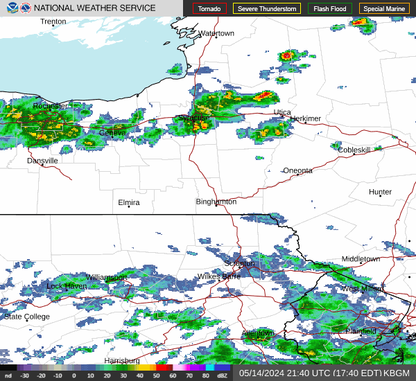
Current Radar Image
Sun Almanac for Johnson City, New York
Sunrise: 07:29 AM
Sunset: 4:35 PM
Civil Sunrise:06:57 AM
Civil Sunset: 5:07 PM
Nautical Sunrise: 06:22 AM
Nautical Sunset: 5:42 PM
Astro Sunrise: 05:48 AM
Astro Sunset: 6:16 PM
New York's Current Temperatures
 New York's Satellite Image
 New York's Current Wind Direction
| National Summary |
of upper and lower values of current conditions amongst 7026 locations
in the contiguous United States |
|
High
Temp |
88° |
Mcallen, Texas
and 1 other location
|
|
Low
Temp |
1° |
Thermal, California
|
|
Wind
Speed |
45mph |
Mammoth Lakes, California
|
|
Wind
Gust |
69mph |
Mammoth Lakes, California
|
|
Wind
Chill |
4° |
Manitowoc, Wisconsin
and 2 other locations
|
|
Heat
Index |
90° |
Falfurrias, Texas
and 1 other location
|
|
High
Pressure |
30.46Hg |
Rensselaer, Indiana
and 4 other locations
|
|
Low
Pressure |
29.44Hg |
Charlie, Montana
|
|
| # Locations Reporting Snow |
27 |
|
| # Locations Reporting Rain |
43 |
|
| # Locations Reporting Fog |
5 |
|
| Average Temperature in the Contiguous USA |
50° |
|
Any use of the information on this page is at your own risk. This information should not be relied upon in life-threatening situations, potential financial loss situations or in lieu of any officially disseminated information. Visit the
National Weather Service for official information.