Grand Forks, North Dakota Weather
Issued: 1:45 am CDT Jul 4, 2025 Latitude: 47.9252568 Longitude: -97.0328547 View on Google Maps
|
|
|
|
|
|
|
|
|
|
 |
 |
 |
 |
|
|
 |
|
| Low: °F |
High: °F |
High: °F |
High: °F |
High: °F |
High: °F |
High: °F |
High: °F |
| Low: °F |
Low: °F |
Low: °F |
Low: °F |
Low: °F |
Low: °F |
|
| Thunderstorms |
Thunderstorms |
Thunderstorms |
Partly Sunny |
Thunderstorms |
Thunderstorms |
Sunny |
Sunny |
Current Conditions at
GRAND FORKS INTL - (KGFK)
81°
Mostly Clear
as of 1:53 AM CDST
Rel. Humidity: 74%
Dew Point: 72°F
Visibility: 10 Miles
Pressure: 29.61 in.
Flight Rule: VFR
Wind Data
15 MPH
Gust: 25 MPH
180° South
Cloud Level(s): Few at 12000ft
Current Conditions at
GRAND FORKS AFB - (KRDR)
81°
Cloudy
Thunderstorm In Vicinity
as of 2:12 AM CDST
Rel. Humidity: 74%
Dew Point: 72°F
Visibility: 10 Miles
Pressure: 29.61 in.
Flight Rule: VFR
Wind Data
14 MPH
200° South
Cloud Level(s): Solid Overcast at 14000ft
Current Conditions at
CROOKSTON MUNICIPAL FIELD - (KCKN)
82°
Clear
as of 2:15 AM CDST
Rel. Humidity: 69%
Dew Point: 72°F
Visibility: 10 Miles
Pressure: 29.65 in.
Flight Rule: VFR
Wind Data
20 MPH
Gust: 26 MPH
170° South
Cloud Level(s): Clear
Current Conditions at
THIEF RIVER FALLS - (KTVF)
77°
Clear
as of 1:56 AM CDST
Rel. Humidity: 83%
Dew Point: 72°F
Visibility: 10 Miles
Pressure: 29.70 in.
Flight Rule: VFR
Wind Data
13 MPH
150° Southeast
Cloud Level(s): Clear
|
Overnight... Isolated showers and thunderstorms. Mostly cloudy, with a low around 72. South wind around 10 mph. Chance of precipitation is 20%. |
|
|
Independence Day... Showers and thunderstorms likely, mainly after 5pm. Some of the storms could produce heavy rainfall. Mostly sunny and hot, with a high near 93. Heat index values as high as 99. Southeast wind 8 to 10 mph becoming southwest in the afternoon. Winds could gust as high as 21 mph. Chance of precipitation is 60%. New rainfall amounts between a quarter and half of an inch possible. |
|
 |
Friday Night... Showers and possibly a thunderstorm before 4am, then showers likely. Some of the storms could produce heavy rainfall. Low around 64. North wind 7 to 10 mph becoming east in the evening. Chance of precipitation is 80%. New rainfall amounts between 1 and 2 inches possible. |
|
|
Saturday... Isolated showers and thunderstorms before 8am, then a slight chance of showers between 8am and 1pm. Partly sunny, with a high near 79. North northwest wind 13 to 16 mph, with gusts as high as 28 mph. Chance of precipitation is 20%. |
|
 |
Saturday Night... Mostly clear, with a low around 54. North northwest wind 8 to 14 mph, with gusts as high as 23 mph. |
|
|
Sunday... Partly sunny, with a high near 74. North northwest wind 7 to 9 mph. |
|
|
Sunday Night... Mostly clear, with a low around 54. North wind 3 to 7 mph. |
|
|
Monday... A 20 percent chance of showers and thunderstorms after 1pm. Sunny, with a high near 79. Light and variable wind becoming south southwest 5 to 8 mph in the morning. |
|
 |
Monday Night... A 30 percent chance of showers and thunderstorms. Partly cloudy, with a low around 59. South wind around 8 mph. |
|
|
Tuesday... A 20 percent chance of showers and thunderstorms after 1pm. Sunny, with a high near 81. West wind around 8 mph. |
|
|
Tuesday Night... Mostly clear, with a low around 59. Northwest wind 5 to 7 mph becoming south in the evening. |
|
|
Wednesday... Sunny, with a high near 85. South wind 6 to 8 mph. |
|
|
Wednesday Night... Mostly clear, with a low around 63. South southeast wind around 7 mph. |
|
|
Thursday... Sunny, with a high near 86. South wind 6 to 9 mph. |
|
Current Radar Image
Sun Almanac for Grand Forks, North Dakota
Sunrise: 05:36 AM
Sunset: 9:30 PM
Civil Sunrise:04:55 AM
Civil Sunset: 10:10 PM
Nautical Sunrise: 03:59 AM
Nautical Sunset: 11:06 PM
Astro Sunrise: 02:33 AM
Astro Sunset: 00:33 PM
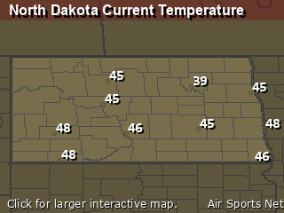
North Dakota's Current Temperatures
 North Dakota's Satellite Image
 North Dakota's Current Wind Direction
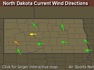
| National Summary |
of upper and lower values of current conditions amongst 7016 locations
in the contiguous United States |
|
High
Temp |
93° |
Lake Havasu City, Arizona
and 1 other location
|
|
Low
Temp |
43° |
Salida Mountain, Colorado
and 1 other location
|
|
Wind
Speed |
35mph |
Eureka, Nevada
|
|
Wind
Gust |
47mph |
Eureka, Nevada
|
|
Wind
Chill |
34° |
Salida Mountain, Colorado
|
|
Heat
Index |
94° |
Garden Banks172, Louisiana
|
|
High
Pressure |
30.59Hg |
Salida Mountain, Colorado
|
|
Low
Pressure |
29.61Hg |
Hutson Field, North Dakota
and 2 other locations
|
|
| # Locations Reporting Rain |
49 |
|
| # Locations Reporting Thunderstorms / Lightning |
11 |
|
| # Locations Reporting Fog |
15 |
|
| Average Temperature in the Contiguous USA |
69° |
|
Any use of the information on this page is at your own risk. This information should not be relied upon in life-threatening situations, potential financial loss situations or in lieu of any officially disseminated information. Visit the
National Weather Service for official information.


