Eiland, New Mexico Weather
No Watches or Warnings for Eiland
Issued: 6:01 am MDT Jul 2, 2025 Latitude: 34.1134162 Longitude: -103.1955049 View on Google Maps
|
|
|
|
|
|
|
|
|
|
 |
 |
 |
 |
 |
 |
 |
|
| High: °F |
Low: °F |
High: °F |
High: °F |
High: °F |
High: °F |
High: °F |
High: °F |
| Low: °F |
Low: °F |
Low: °F |
Low: °F |
Low: °F |
|
| Thunderstorms |
Thunderstorms |
Thunderstorms |
Mostly Sunny |
Sunny |
Thunderstorms |
Partly Sunny |
Mostly Sunny |
Current Conditions at
CLOVIS - (KCVN)
70°
Cloudy
as of 9:56 AM MDST
Rel. Humidity: 77%
Dew Point: 63°F
Visibility: 10 Miles
Pressure: 30.21 in.
Flight Rule: MVFR
Wind Data
12 MPH
170° South
Cloud Level(s): Broken at 1300ft, Broken at 1900ft, Solid Overcast at 2900ft
Current Conditions at
TUCUMCARI - (KTCC)
73°
Mostly Clear
as of 9:53 AM MDST
Rel. Humidity: 69%
Dew Point: 63°F
Visibility: 10 Miles
Pressure: 30.14 in.
Flight Rule: VFR
Wind Data
13 MPH
Gust: 17 MPH
190° South
Cloud Level(s): Few at 3200ft
Current Conditions at
PLAINVIEW - (KPVW)
66°
Cloudy
Light Rain
as of 10:50 AM CDST
Rel. Humidity: 93%
Dew Point: 64°F
Visibility: 7 Miles
Pressure: 30.20 in.
Flight Rule: IFR
Cloud Level(s): Broken at 800ft, Broken at 1300ft, Solid Overcast at 5000ft
|
Today... Scattered showers and thunderstorms, then showers likely and possibly a thunderstorm after 3pm. Cloudy, with a high near 78. South wind 10 to 15 mph. Chance of precipitation is 60%. New rainfall amounts of less than a tenth of an inch, except higher amounts possible in thunderstorms. |
|
|
Tonight... Scattered showers and thunderstorms. Mostly cloudy, with a low around 63. South wind 5 to 15 mph. Chance of precipitation is 50%. New rainfall amounts of less than a tenth of an inch, except higher amounts possible in thunderstorms. |
|
|
Thursday... Scattered showers and thunderstorms. Mostly cloudy, with a high near 83. South wind 5 to 15 mph. Chance of precipitation is 50%. New rainfall amounts between a tenth and quarter of an inch, except higher amounts possible in thunderstorms. |
|
|
Thursday Night... Scattered showers and thunderstorms before midnight. Mostly cloudy, with a low around 65. South wind 10 to 15 mph. Chance of precipitation is 50%. |
|
|
Independence Day... Mostly sunny, with a high near 93. Southwest wind around 10 mph. |
|
 |
Friday Night... Mostly clear, with a low around 66. |
|
|
Saturday... Sunny and hot, with a high near 97. |
|
 |
Saturday Night... A 20 percent chance of showers and thunderstorms before midnight. Partly cloudy, with a low around 65. |
|
|
Sunday... A 30 percent chance of showers and thunderstorms after noon. Partly sunny, with a high near 93. |
|
 |
Sunday Night... A 40 percent chance of showers and thunderstorms before midnight. Mostly cloudy, with a low around 64. |
|
|
Monday... Partly sunny, with a high near 90. |
|
 |
Monday Night... A 20 percent chance of showers and thunderstorms. Mostly cloudy, with a low around 65. |
|
|
Tuesday... Mostly sunny, with a high near 91. |
|
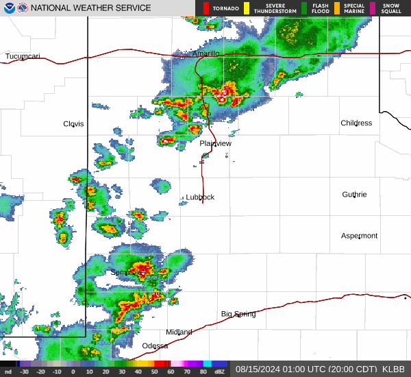
Current Radar Image
Sun Almanac for Eiland, New Mexico
Sunrise: 05:46 AM
Sunset: 8:08 PM
Civil Sunrise:05:17 AM
Civil Sunset: 8:37 PM
Nautical Sunrise: 04:41 AM
Nautical Sunset: 9:13 PM
Astro Sunrise: 04:02 AM
Astro Sunset: 9:52 PM
New Mexico's Current Temperatures
 New Mexico's Satellite Image
 New Mexico's Current Wind Direction
| National Summary |
of upper and lower values of current conditions amongst 5039 locations
in the contiguous United States |
|
High
Temp |
97° |
Buckeye Municipal A/P, Arizona
and 1 other location
|
|
Low
Temp |
50° |
Fortuna, California
|
|
Wind
Speed |
28mph |
Yuma Aux, Arizona
|
|
Wind
Gust |
43mph |
Yuma Aux, Arizona
|
|
Heat
Index |
109° |
Abbeville Cc Mem, Louisiana
|
|
High
Pressure |
30.73Hg |
Salida Mountain, Colorado
|
|
Low
Pressure |
29.73Hg |
Clayton Lake, Maine
|
|
| # Locations Reporting Rain |
39 |
|
| # Locations Reporting Thunderstorms / Lightning |
16 |
|
| Average Temperature in the Contiguous USA |
78° |
|
Any use of the information on this page is at your own risk. This information should not be relied upon in life-threatening situations, potential financial loss situations or in lieu of any officially disseminated information. Visit the
National Weather Service for official information.