Dataw Island, South Carolina Weather
No Watches or Warnings for Dataw Island
|
|
|
|
|
|
|
|
 |
 |
 |
|
 |
 |
 |
|
| Low: °F |
High: °F |
High: °F |
High: °F |
High: °F |
High: °F |
High: °F |
High: °F |
| Low: °F |
Low: °F |
Low: °F |
Low: °F |
Low: °F |
Low: °F |
|
| Mostly Clear |
Thunderstorms |
Sunny |
Sunny |
Thunderstorms |
Thunderstorms |
Thunderstorms |
Thunderstorms |
Current Conditions at
BEAUFORT MCAS - (KNBC)
81°
Mostly Clear
as of 10:56 PM EDST
Rel. Humidity: 88%
Dew Point: 77°F
Visibility: 7 Miles
Pressure: 30.13 in.
Flight Rule: VFR
Cloud Level(s): Few at 3000ft
Current Conditions at
HILTON HEAD - (KHXD)
82°
Partly Cloudy
as of 11:35 PM EDST
Rel. Humidity: 83%
Dew Point: 77°F
Visibility: 10 Miles
Pressure: 30.15 in.
Flight Rule: VFR
Wind Data
12 MPH
200° South
Cloud Level(s): Few at 1700ft, Scattered at 2100ft
Current Conditions at
SAVANNAH - (KSAV)
81°
Mostly Clear
as of 10:53 PM EDST
Rel. Humidity: 88%
Dew Point: 77°F
Visibility: 10 Miles
Pressure: 30.14 in.
Flight Rule: VFR
Cloud Level(s): Few at 1600ft
Current Conditions at
SYLVANIA - (KJYL)
81°
Clear
as of 11:35 PM EDST
Rel. Humidity: 94%
Dew Point: 79°F
Visibility: 10 Miles
Pressure: 30.14 in.
Flight Rule: VFR
Cloud Level(s): Clear
|
Overnight... Mostly clear, with a low around 79. South wind around 6 mph. |
|
|
Friday... A 20 percent chance of showers and thunderstorms after 2pm. Mostly sunny, with a high near 94. Heat index values as high as 106. South wind 5 to 9 mph. |
|
|
Friday Night... Mostly clear, with a low around 78. Southwest wind 6 to 8 mph. |
|
|
Saturday... Sunny, with a high near 96. Heat index values as high as 108. West wind 6 to 8 mph. |
|
|
Saturday Night... Mostly clear, with a low around 80. South wind 6 to 8 mph. |
|
|
Sunday... Sunny, with a high near 98. |
|
 |
Sunday Night... A 20 percent chance of showers and thunderstorms before 2am. Partly cloudy, with a low around 80. |
|
|
Monday... A 40 percent chance of showers and thunderstorms, mainly after 2pm. Mostly sunny, with a high near 97. |
|
 |
Monday Night... A 40 percent chance of showers and thunderstorms, mainly before 2am. Mostly cloudy, with a low around 77. |
|
|
Tuesday... Showers and thunderstorms likely, mainly after 2pm. Partly sunny, with a high near 91. Chance of precipitation is 60%. |
|
 |
Tuesday Night... Showers and thunderstorms likely. Mostly cloudy, with a low around 76. Chance of precipitation is 60%. |
|
|
Wednesday... A 50 percent chance of showers and thunderstorms. Partly sunny, with a high near 90. |
|
|
Wednesday Night... A 20 percent chance of showers and thunderstorms. Partly cloudy, with a low around 76. |
|
|
Thursday... A 40 percent chance of showers and thunderstorms. Mostly sunny, with a high near 92. |
|
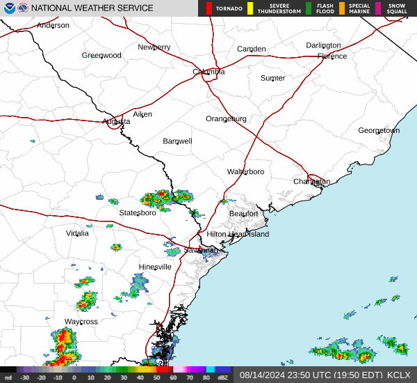
Current Radar Image
Sun Almanac for Dataw Island, South Carolina
Sunrise: 06:28 AM
Sunset: 8:29 PM
Civil Sunrise:06:01 AM
Civil Sunset: 8:57 PM
Nautical Sunrise: 05:27 AM
Nautical Sunset: 9:30 PM
Astro Sunrise: 04:51 AM
Astro Sunset: 10:06 PM
South Carolina's Current Temperatures
 South Carolina's Satellite Image
 South Carolina's Current Wind Direction
| National Summary |
of upper and lower values of current conditions amongst 6966 locations
in the contiguous United States |
|
High
Temp |
99° |
Laguna (Aaf), Arizona
and 4 other locations
|
|
Low
Temp |
46° |
Pagosa Springs, Colorado
|
|
Wind
Speed |
32mph |
Tucumcari, New Mexico
|
|
Wind
Gust |
49mph |
Tucumcari, New Mexico
|
|
Heat
Index |
107° |
Edenton, North Carolina
|
|
High
Pressure |
30.72Hg |
Salida Mountain, Colorado
|
|
Low
Pressure |
29.54Hg |
Caribou, Maine
|
|
| # Locations Reporting Rain |
49 |
|
| # Locations Reporting Thunderstorms / Lightning |
13 |
|
| # Locations Reporting Fog |
4 |
|
| Average Temperature in the Contiguous USA |
74° |
|
Any use of the information on this page is at your own risk. This information should not be relied upon in life-threatening situations, potential financial loss situations or in lieu of any officially disseminated information. Visit the
National Weather Service for official information.