Crystal Springs, Kansas Weather
Current Conditions at
MEDICINE LAKE - (KP28)
66°
Cloudy
as of 3:56 AM CDST
Rel. Humidity: 72%
Dew Point: 57°F
Pressure: 29.66 in.
Wind Data
10 MPH
Gust: 20 MPH
160° South
Current Conditions at
ALVA REGIONAL AIRPT - (KAVK)
70°
Clear
as of 3:55 AM CDST
Rel. Humidity: 77%
Dew Point: 63°F
Visibility: 10 Miles
Pressure: 29.66 in.
Flight Rule: VFR
Wind Data
17 MPH
Gust: 24 MPH
190° South
Cloud Level(s): Clear
Current Conditions at
PRATT - (KPTT)
64°
Clear
as of 3:55 AM CDST
Rel. Humidity: 67%
Dew Point: 54°F
Visibility: 10 Miles
Pressure: 29.66 in.
Flight Rule: VFR
Wind Data
16 MPH
Gust: 21 MPH
170° South
Cloud Level(s): Clear
Current Conditions at
WICHITA MID-CONTINENT - (KICT)
66°
Mostly Cloudy
as of 3:53 AM CDST
Rel. Humidity: 88%
Dew Point: 63°F
Visibility: 10 Miles
Pressure: 29.69 in.
Flight Rule: VFR
Wind Data
18 MPH
160° South
Cloud Level(s): Scattered at 2500ft, Scattered at 18000ft, Broken at 25000ft
Moon Almanac for Crystal Springs, Kansas
Moon Phase: Full Moon
Moon Illumination: 98%
Moon Age: 16.0 Days
Moon is currently above the horizon
Distance from Moon to Earth: 248,047 miles
Upcoming Lunar Events for
Crystal Springs: |
| Next Event | Event Time | Illum |
|
|
|
| Moonset: | 08:43 am Fri | 97.9% |
| Moonrise: | 10:56 pm Fri | 96.0% |
| High Moon: | 04:07 am Sat | 95.1% |
| Moonset: | 09:11 am Sat | 94.2% |
 | New Moon: Wed Mar 18 |
 | First Quarter: Wed Mar 25 |
 | Full Moon: Wed Apr 1 |
 | Last Quarter: Fri Apr 10 |
| New Moon: Fri Apr 17 |
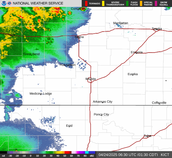
Current Radar Image
| Kansas State Summary |
of upper and lower values of current conditions amongst 33 locations
in Kansas |
|
High
Temp |
70° |
Winfield
and 2 other locations
|
|
|
|
|
|
|
|
Wind
Chill |
37° |
Concordia
and 1 other location
|
|
High
Pressure |
29.86Hg |
Olathe/Industrial
and 1 other location
|
|
Low
Pressure |
29.60Hg |
Russell
|
|
| Average temperature in Kansas |
58° |
|
# Locations Reporting MVFR
(Marginal Visual Flight Rules) |
1 |
|
# Locations Reporting VFR
(Visual Flight Rules) |
32 |
|
Kansas' Current Temperatures
 Kansas' Satellite Image
 Kansas' Current Wind Direction
| National Summary |
of upper and lower values of current conditions amongst 6707 locations
in the contiguous United States |
|
High
Temp |
79° |
Key West Intl, Florida
|
|
Low
Temp |
5° |
Berthoud Pass, Colorado
|
|
Wind
Speed |
39mph |
Lima Madis, Colorado
|
|
Wind
Gust |
49mph |
Lima Madis, Colorado
|
|
Wind
Chill |
-16° |
Berthoud Pass, Colorado
|
|
High
Pressure |
30.48Hg |
Bar Harbor, Maine
|
|
Low
Pressure |
29.59Hg |
Sault Ste Marie, Michigan
|
|
| # Locations Reporting Snow |
74 |
|
| # Locations Reporting Rain |
36 |
|
| # Locations Reporting Thunderstorms / Lightning |
1 |
|
| # Locations Reporting Fog |
22 |
|
| Average Temperature in the Contiguous USA |
52° |
|
Any use of the information on this page is at your own risk. This information should not be relied upon in life-threatening situations, potential financial loss situations or in lieu of any officially disseminated information. Visit the
National Weather Service for official information.