Chepachet, Rhode Island Weather
No Watches or Warnings for Chepachet
Issued: 12:57 pm EDT Jun 2, 2025 Latitude: 41.9150986 Longitude: -71.6714555 View on Google Maps
|
|
|
|
|
|
|
|
|
|
 |
 |
 |
|
|
 |
 |
|
| High: °F |
Low: °F |
High: °F |
High: °F |
High: °F |
High: °F |
High: °F |
High: °F |
| Low: °F |
Low: °F |
Low: °F |
Low: °F |
Low: °F |
|
| Mostly Sunny |
Rain |
Sunny |
Sunny |
Mostly Sunny |
Partly Sunny |
Rain |
Mostly Sunny |
Current Conditions at
N CENTRAL STATE ARP - (KSFZ)
66°
Mostly Cloudy
as of 12:56 PM EDST
Rel. Humidity: 48%
Dew Point: 46°F
Visibility: 10 Miles
Pressure: 29.95 in.
Flight Rule: VFR
Cloud Level(s): Broken at 4900ft
Current Conditions at
PROVIDENCE - (KPVD)
66°
Partly Cloudy
as of 12:51 PM EDST
Rel. Humidity: 45%
Dew Point: 45°F
Visibility: 10 Miles
Pressure: 29.96 in.
Flight Rule: VFR
Wind Data
15 MPH
Gust: 21 MPH
260° West
Cloud Level(s): Scattered at 5000ft, Scattered at 25000ft
Current Conditions at
KINGSTON - (KOQU)
68°
Mostly Clear
as of 1:15 PM EDST
Rel. Humidity: 42%
Dew Point: 45°F
Visibility: 10 Miles
Pressure: 29.94 in.
Flight Rule: VFR
Wind Data
10 MPH
Gust: 16 MPH
310° Northwest
Cloud Level(s): Few at 5000ft
Current Conditions at
WORCESTER - (KORH)
61°
Mostly Cloudy
as of 12:54 PM EDST
Rel. Humidity: 51%
Dew Point: 43°F
Visibility: 10 Miles
Pressure: 29.95 in.
Flight Rule: VFR
Wind Data
14 MPH
Gust: 21 MPH
240° Southwest
Cloud Level(s): Broken at 4400ft, Broken at 5000ft
|
This Afternoon... Mostly sunny, with a high near 69. West wind around 8 mph. |
|
|
Tonight... A slight chance of showers before 9pm. Mostly cloudy, then gradually becoming clear, with a low around 48. Southwest wind 3 to 5 mph. Chance of precipitation is 20%. |
|
|
Tuesday... Sunny, with a high near 78. Calm wind becoming northwest around 5 mph. |
|
 |
Tuesday Night... Mostly clear, with a low around 55. Southwest wind around 5 mph. |
|
|
Wednesday... Sunny, with a high near 85. Southwest wind 5 to 8 mph. |
|
|
Wednesday Night... Mostly clear, with a low around 61. Southwest wind around 7 mph. |
|
|
Thursday... Mostly sunny, with a high near 89. Southwest wind 6 to 8 mph. |
|
 |
Thursday Night... Mostly cloudy, with a low around 66. West wind around 7 mph. |
|
|
Friday... A chance of showers after 3pm. Partly sunny, with a high near 84. Southwest wind 6 to 9 mph. Chance of precipitation is 30%. |
|
 |
Friday Night... Showers likely, mainly after 3am. Cloudy, with a low around 63. Southwest wind around 7 mph. Chance of precipitation is 60%. |
|
|
Saturday... Showers likely. Mostly cloudy, with a high near 78. Southwest wind 7 to 9 mph. Chance of precipitation is 60%. |
|
 |
Saturday Night... A chance of showers. Mostly cloudy, with a low around 59. Northwest wind around 7 mph. Chance of precipitation is 50%. |
|
|
Sunday... Mostly sunny, with a high near 77. North wind around 8 mph. |
|
Current Radar Image
Sun Almanac for Chepachet, Rhode Island
Sunrise: 05:13 AM
Sunset: 8:16 PM
Civil Sunrise:04:40 AM
Civil Sunset: 8:50 PM
Nautical Sunrise: 03:57 AM
Nautical Sunset: 9:33 PM
Astro Sunrise: 03:06 AM
Astro Sunset: 10:24 PM
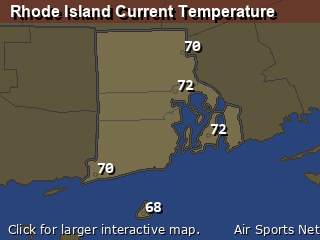
Rhode Island's Current Temperatures
 Rhode Island's Satellite Image
 Rhode Island's Current Wind Direction
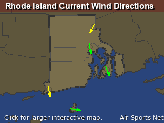
| National Summary |
of upper and lower values of current conditions amongst 6994 locations
in the contiguous United States |
|
High
Temp |
95° |
Sweetwater, Texas
and 1 other location
|
|
Low
Temp |
37° |
Pagosa Springs, Colorado
|
|
Wind
Speed |
36mph |
Boysen/Thermopol, Wyoming
|
|
Wind
Gust |
39mph |
Boysen/Thermopol, Wyoming
and 1 other location
|
|
Wind
Chill |
27° |
Pagosa Springs, Colorado
|
|
Heat
Index |
110° |
KingsvilleNAS, Texas
|
|
High
Pressure |
30.51Hg |
Salida Mountain, Colorado
|
|
Low
Pressure |
29.34Hg |
Eagle Range, Utah
|
|
| # Locations Reporting Rain |
44 |
|
| # Locations Reporting Thunderstorms / Lightning |
11 |
|
| Average Temperature in the Contiguous USA |
75° |
|
Any use of the information on this page is at your own risk. This information should not be relied upon in life-threatening situations, potential financial loss situations or in lieu of any officially disseminated information. Visit the
National Weather Service for official information.


