Montague, New Jersey Weather
Current Conditions at
SUSSEX - (KFWN)
72°
Clear
as of 3:53 PM EDST
Rel. Humidity: 19%
Dew Point: 28°F
Visibility: 10 Miles
Pressure: 29.96 in.
Flight Rule: VFR
Wind Data
8 MPH
Gust: 23 MPH
220° Southwest
Cloud Level(s): Clear
Current Conditions at
ANDOVER - (K12N)
70°
Clear
as of 3:54 PM EDST
Rel. Humidity: 28%
Dew Point: 36°F
Pressure: 29.96 in.
Wind Data
14 MPH
Gust: 23 MPH
220° Southwest
Current Conditions at
MONTICELLO - (KMSV)
66°
Clear
as of 3:56 PM EDST
Rel. Humidity: 24%
Dew Point: 28°F
Visibility: 10 Miles
Pressure: 29.94 in.
Flight Rule: VFR
Wind Data
12 MPH
210° Southwest
Cloud Level(s): Clear
Current Conditions at
MONTGOMERY - (KMGJ)
70°
Clear
as of 3:54 PM EDST
Rel. Humidity: 26%
Dew Point: 34°F
Visibility: 10 Miles
Pressure: 29.93 in.
Flight Rule: VFR
Wind Data
14 MPH
Gust: 25 MPH
200° South
Cloud Level(s): Clear
Sun Almanac for Montague, New Jersey
Astronomical Sunrise: 05:48 AM
Nautical Sunrise: 06:21 AM
Civil Sunrise:06:53 AM
Sunrise: 07:20 AM
Sunset: 6:59 PM
Civil Sunset: 7:26 PM
Nautical Sunset: 7:58 PM
Astronomical Sunset: 8:31 PM
Moon Almanac for Montague, New Jersey
Moon Phase: Waning Gibbous
Moon Illumination: 65%
Moon Age: 20.7 Days
Moon is currently below the horizon
Distance from Moon to Earth: 251,866 miles
Upcoming Lunar Events for
Montague: |
| Next Event | Event Time | Illum |
|
|
|
| Moonrise: | 01:50 am Tue | 60.9% |
| High Moon: | 06:13 am Tue | 59.2% |
| Moonset: | 10:33 am Tue | 57.5% |
 | New Moon: Tue Feb 17 |
 | First Quarter: Tue Feb 24 |
 | Full Moon: Tue Mar 3 |
 | Last Quarter: Wed Mar 11 |
| New Moon: Wed Mar 18 |
Current Radar Image
| National Summary |
of upper and lower values of current conditions amongst 6558 locations
in the contiguous United States |
|
| High |
91° |
Falfurrias, Texas
and 1 other location
|
|
| Low |
14° |
Cavalier Municipal A/P, North Dakota
and 2 other locations
|
|
Wind
Speed |
41mph |
| Casper, Wyoming
|
|
Wind
Gust |
58mph |
Converse County Arpt, Wyoming
and 1 other location
|
|
Wind
Chill |
0° |
Cavalier Municipal A/P, North Dakota
and 2 other locations
|
|
Heat
Index |
93° |
Edinburg Intl Arpt, Texas
and 1 other location
|
|
High
Pressure |
30.25Hg |
| Pagosa Springs, Texas
|
|
Low
Pressure |
29.51Hg |
| Worland, Wyoming
|
|
| # Locations Reporting Snow |
10 |
|
| # Locations Reporting Rain |
24 |
|
| # Locations Reporting Thunderstorms |
6 |
|
| Average Temperature in the Contiguous USA |
68° |
|
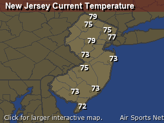
New Jersey's Current Temperatures
 New Jersey's Satellite Image
 New Jersey's Current Wind Direction
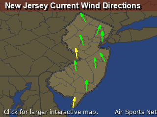
| National Summary |
of upper and lower values of current conditions amongst 4301 locations
in the contiguous United States |
|
High
Temp |
88° |
Altus, Oklahoma
|
|
Low
Temp |
14° |
Robertson Field, North Dakota
|
|
Wind
Speed |
29mph |
Plainview, Texas
|
|
Wind
Gust |
38mph |
Blytheville, Arkansas
|
|
Wind
Chill |
0° |
Robertson Field, North Dakota
and 1 other location
|
|
High
Pressure |
30.14Hg |
Thomaston, Georgia
and 1 other location
|
|
Low
Pressure |
29.60Hg |
Powell, Wyoming
|
|
| # Locations Reporting Snow |
3 |
|
| # Locations Reporting Rain |
19 |
|
| # Locations Reporting Thunderstorms / Lightning |
7 |
|
| # Locations Reporting Fog |
1 |
|
| Average Temperature in the Contiguous USA |
71° |
|
Any use of the information on this page is at your own risk. This information should not be relied upon in life-threatening situations, potential financial loss situations or in lieu of any officially disseminated information. Visit the
National Weather Service for official information.


