Ridgewood, Georgia Weather
Current Conditions at
THOMSON - (KHQU)
81°
Mostly Cloudy
as of 3:30 PM EDST
Rel. Humidity: 44%
Dew Point: 57°F
Visibility: 10 Miles
Pressure: 29.94 in.
Flight Rule: VFR
Cloud Level(s): Broken at 4800ft
Current Conditions at
WASHINGTON-WILKES A/P - (KIIY)
81°
Partly Cloudy
as of 3:35 PM EDST
Rel. Humidity: 47%
Dew Point: 59°F
Visibility: 10 Miles
Pressure: 29.90 in.
Flight Rule: VFR
Cloud Level(s): Scattered at 4600ft
Moon Almanac for Ridgewood, Georgia
Moon Phase: Waxing Gibbous
Moon Illumination: 78%
Moon Age: 10.1 Days
Moon is currently above the horizon
Distance from Moon to Earth: 237,301 miles
Upcoming Lunar Events for
Ridgewood: |
| Next Event | Event Time | Illum |
|
|
|
| High Moon: | 10:07 pm Sun | 79.9% |
| Moonset: | 04:29 am Mon | 82.1% |
| Moonrise: | 04:36 pm Mon | 85.9% |
| High Moon: | 10:49 pm Mon | 87.7% |
| Moonset: | 04:54 am Tue | 89.3% |
 | New Moon: Fri Apr 17 |
 | First Quarter: Thu Apr 23 |
 | Full Moon: Fri May 1 |
 | Last Quarter: Sat May 9 |
| New Moon: Sat May 16 |
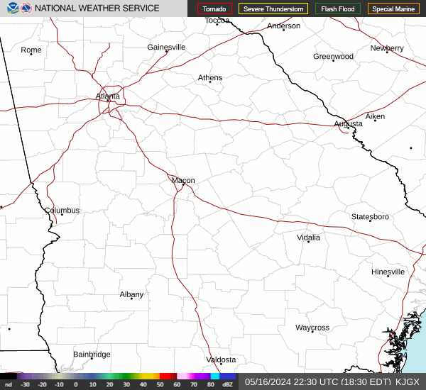
Current Radar Image
| Georgia State Summary |
of upper and lower values of current conditions amongst 48 locations
in Georgia |
|
High
Temp |
86° |
Waycross
and 6 other locations
|
|
Low
Temp |
75° |
Toccoa
and 1 other location
|
|
Wind
Speed |
12mph |
Bainbridge
and 4 other locations
|
|
|
|
High
Pressure |
29.96Hg |
Carrollton
|
|
Low
Pressure |
29.82Hg |
Claxton-Evans Cnty A/P
and 2 other locations
|
|
| Average temperature in Georgia |
81° |
|
| # Locations Reporting Rain |
1 |
|
# Locations Reporting VFR
(Visual Flight Rules) |
48 |
|
Georgia's Current Temperatures
 Georgia's Satellite Image
 Georgia's Current Wind Direction
| National Summary |
of upper and lower values of current conditions amongst 7026 locations
in the contiguous United States |
|
High
Temp |
97° |
Sweetwater, Texas
and 1 other location
|
|
Low
Temp |
25° |
Berthoud Pass, Colorado
|
|
Wind
Speed |
46mph |
Ruidoso, New Mexico
|
|
Wind
Gust |
61mph |
Ruidoso, New Mexico
|
|
Wind
Chill |
10° |
Berthoud Pass, Colorado
|
|
Heat
Index |
100° |
Edinburg Intl Arpt, Texas
and 1 other location
|
|
High
Pressure |
30.18Hg |
Williamson/Sodus, New York
and 2 other locations
|
|
Low
Pressure |
29.60Hg |
Rock Springs, Wyoming
and 2 other locations
|
|
| # Locations Reporting Snow |
22 |
|
| # Locations Reporting Rain |
95 |
|
| # Locations Reporting Thunderstorms / Lightning |
11 |
|
| # Locations Reporting Fog |
4 |
|
| Average Temperature in the Contiguous USA |
65° |
|
Any use of the information on this page is at your own risk. This information should not be relied upon in life-threatening situations, potential financial loss situations or in lieu of any officially disseminated information. Visit the
National Weather Service for official information.