Centerville, Rhode Island Weather
No Watches or Warnings for Centerville
Issued: 2:50 pm EDT Jun 5, 2025 Latitude: 41.6964894 Longitude: -71.5225609 View on Google Maps
|
|
|
|
|
|
|
|
|
|
 |
 |
 |
 |
 |
 |
 |
 |
| Low: °F |
High: °F |
High: °F |
High: °F |
High: °F |
High: °F |
High: °F |
High: °F |
| Low: °F |
Low: °F |
Low: °F |
Low: °F |
Low: °F |
Low: °F |
|
| Mostly Cloudy |
Thunderstorms |
Thunderstorms |
Mostly Cloudy |
Partly Sunny |
Rain |
Rain |
Sunny |
Current Conditions at
PROVIDENCE - (KPVD)
77°
Mostly Cloudy
as of 9:51 PM EDST
Rel. Humidity: 65%
Dew Point: 64°F
Visibility: 10 Miles
Pressure: 29.95 in.
Flight Rule: VFR
Wind Data
7 MPH
220° Southwest
Cloud Level(s): Broken at 25000ft
Current Conditions at
KINGSTON - (KOQU)
73°
Clear
as of 9:50 PM EDST
Rel. Humidity: 83%
Dew Point: 68°F
Visibility: 10 Miles
Pressure: 29.96 in.
Flight Rule: VFR
Wind Data
8 MPH
240° Southwest
Cloud Level(s): Clear
Current Conditions at
N CENTRAL STATE ARP - (KSFZ)
75°
Clear
as of 9:56 PM EDST
Rel. Humidity: 73%
Dew Point: 66°F
Visibility: 10 Miles
Pressure: 29.96 in.
Flight Rule: VFR
Cloud Level(s): Clear
Current Conditions at
NEWPORT - (KUUU)
72°
Clear
as of 9:53 PM EDST
Rel. Humidity: 73%
Dew Point: 63°F
Visibility: 10 Miles
Pressure: 29.96 in.
Flight Rule: VFR
Cloud Level(s): Clear
|
Tonight... Mostly cloudy, with a low around 65. West wind around 6 mph becoming calm after midnight. |
|
|
Friday... A slight chance of showers, then a chance of showers and thunderstorms after 11am. Partly sunny, with a high near 83. Calm wind becoming south 5 to 9 mph in the morning. Chance of precipitation is 30%. |
|
 |
Friday Night... A chance of showers and thunderstorms. Mostly cloudy, with a low around 61. South wind around 7 mph. Chance of precipitation is 30%. New precipitation amounts of less than a tenth of an inch, except higher amounts possible in thunderstorms. |
|
|
Saturday... A chance of showers, with thunderstorms also possible after 2pm. Mostly cloudy, with a high near 76. South wind around 7 mph. Chance of precipitation is 50%. New rainfall amounts between a tenth and quarter of an inch, except higher amounts possible in thunderstorms. |
|
|
Saturday Night... A chance of showers and thunderstorms before 9pm, then a slight chance of showers between 9pm and 11pm. Mostly cloudy, with a low around 59. West wind around 5 mph becoming northwest after midnight. Chance of precipitation is 30%. |
|
|
Sunday... Mostly cloudy, with a high near 76. North wind 6 to 8 mph becoming east in the afternoon. |
|
 |
Sunday Night... A chance of showers after 11pm. Mostly cloudy, with a low around 55. East wind 3 to 6 mph. Chance of precipitation is 30%. |
|
|
Monday... Partly sunny, with a high near 74. Northeast wind 6 to 9 mph becoming southeast in the afternoon. |
|
|
Monday Night... Mostly cloudy, with a low around 59. Southeast wind 3 to 7 mph. |
|
|
Tuesday... A chance of showers after 10am. Cloudy, with a high near 73. Southeast wind 5 to 9 mph. Chance of precipitation is 40%. |
|
 |
Tuesday Night... Showers likely. Cloudy, with a low around 61. South wind around 7 mph. Chance of precipitation is 60%. |
|
|
Wednesday... A chance of showers. Mostly sunny, with a high near 79. Southwest wind 6 to 10 mph. Chance of precipitation is 30%. |
|
 |
Wednesday Night... Mostly clear, with a low around 60. West wind around 6 mph. |
|
|
Thursday... Sunny, with a high near 82. West wind 6 to 10 mph. |
|
Current Radar Image
Sun Almanac for Centerville, Rhode Island
Sunrise: 05:12 AM
Sunset: 8:17 PM
Civil Sunrise:04:39 AM
Civil Sunset: 8:51 PM
Nautical Sunrise: 03:56 AM
Nautical Sunset: 9:34 PM
Astro Sunrise: 03:05 AM
Astro Sunset: 10:25 PM
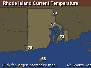
Rhode Island's Current Temperatures
 Rhode Island's Satellite Image
 Rhode Island's Current Wind Direction
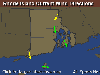
| National Summary |
of upper and lower values of current conditions amongst 6917 locations
in the contiguous United States |
|
High
Temp |
99° |
Gila Bend (Aaf), Arizona
and 3 other locations
|
|
Low
Temp |
34° |
Salida Mountain, Colorado
|
|
Wind
Speed |
30mph |
Artesia, New Mexico
|
|
Wind
Gust |
62mph |
Terrel County Arpt, Texas
|
|
Wind
Chill |
21° |
Salida Mountain, Colorado
|
|
High
Pressure |
30.50Hg |
Salida Mountain, Colorado
|
|
Low
Pressure |
29.64Hg |
Thermal, California
|
|
| # Locations Reporting Snow |
1 |
|
| # Locations Reporting Rain |
103 |
|
| # Locations Reporting Thunderstorms / Lightning |
14 |
|
| # Locations Reporting Fog |
2 |
|
| Average Temperature in the Contiguous USA |
71° |
|
Any use of the information on this page is at your own risk. This information should not be relied upon in life-threatening situations, potential financial loss situations or in lieu of any officially disseminated information. Visit the
National Weather Service for official information.


