No Watches or Warnings for Concord
Issued: 1:51 pm CST Dec 16, 2025 Latitude: 33.5456681 Longitude: -87.730291 View on Google Maps
|
|
|
|
|
|
|
|
|
|
 |
 |
 |
 |
 |
|
 |
|
| High: °F |
Low: °F |
High: °F |
High: °F |
High: °F |
High: °F |
High: °F |
High: °F |
| Low: °F |
Low: °F |
Low: °F |
Low: °F |
Low: °F |
|
| Mostly Sunny |
Mostly Cloudy |
Mostly Cloudy |
Thunderstorms |
Sunny |
Sunny |
Rain |
Rain |
Current Conditions at
TUSCALOOSA - (KTCL)
57°
Clear
as of 2:53 PM CST
Rel. Humidity: 19%
Dew Point: 16°F
Visibility: 10 Miles
Pressure: 30.20 in.
Flight Rule: VFR
Wind Data
6 MPH
220° Southwest
Cloud Level(s): Clear
Current Conditions at
COLUMBUS AFB - (KCBM)
57°
Clear
as of 2:55 PM CST
Rel. Humidity: 20%
Dew Point: 18°F
Visibility: 10 Miles
Pressure: 30.14 in.
Flight Rule: VFR
Cloud Level(s): Clear
Current Conditions at
COLUMBUS ARPT - (KGTR)
54°
Clear
as of 2:56 PM CST
Rel. Humidity: 32%
Dew Point: 25°F
Visibility: 10 Miles
Pressure: 30.19 in.
Flight Rule: VFR
Cloud Level(s): Clear
Current Conditions at
BIRMINGHAM - (KBHM)
59°
Mostly Clear
as of 2:53 PM CST
Rel. Humidity: 15%
Dew Point: 12°F
Visibility: 10 Miles
Pressure: 30.22 in.
Flight Rule: VFR
Cloud Level(s): Few at 25000ft
|
This Afternoon... Mostly sunny, with a high near 54. South wind around 5 mph. |
|
|
Tonight... Mostly cloudy, with a low around 35. South wind around 5 mph becoming calm. |
|
|
Wednesday... Mostly cloudy, with a high near 57. Calm wind. |
|
 |
Wednesday Night... A 30 percent chance of rain after midnight. Mostly cloudy, with a low around 43. Calm wind becoming southeast around 5 mph after midnight. |
|
|
Thursday... Rain likely, then showers and possibly a thunderstorm after noon. High near 61. South wind 5 to 10 mph, with gusts as high as 20 mph. Chance of precipitation is 90%. |
|
 |
Thursday Night... A 50 percent chance of showers and thunderstorms before midnight. Mostly cloudy during the early evening, then gradual clearing, with a low around 34. |
|
|
Friday... Sunny, with a high near 48. |
|
 |
Friday Night... Clear, with a low around 31. |
|
|
Saturday... Sunny, with a high near 60. |
|
 |
Saturday Night... A 20 percent chance of rain after midnight. Partly cloudy, with a low around 47. |
|
|
Sunday... A 20 percent chance of rain. Partly sunny, with a high near 65. |
|
|
Sunday Night... A 20 percent chance of rain. Partly cloudy, with a low around 47. |
|
|
Monday... A 20 percent chance of rain. Partly sunny, with a high near 66. |
|
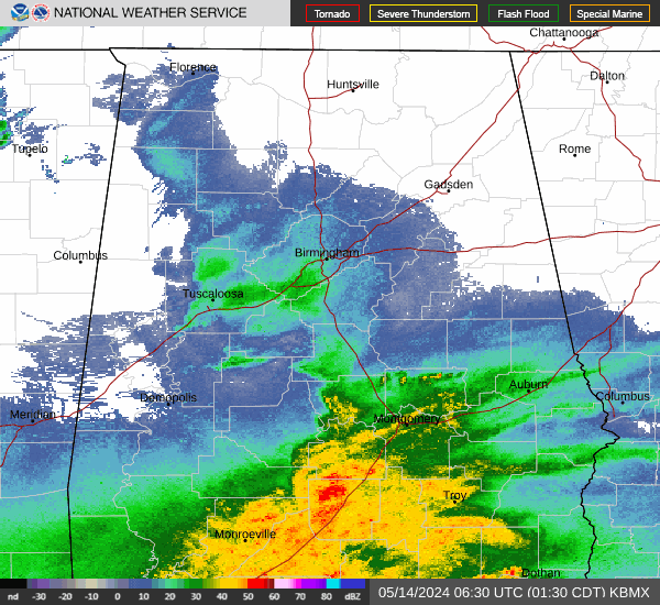
Current Radar Image
Sun Almanac for Concord, Alabama
Sunrise: 06:49 AM
Sunset: 4:45 PM
Civil Sunrise:06:21 AM
Civil Sunset: 5:12 PM
Nautical Sunrise: 05:50 AM
Nautical Sunset: 5:43 PM
Astro Sunrise: 05:20 AM
Astro Sunset: 6:14 PM
Alabama's Current Temperatures
 Alabama's Satellite Image
 Alabama's Current Wind Direction
| National Summary |
of upper and lower values of current conditions amongst 7109 locations
in the contiguous United States |
|
High
Temp |
84° |
Murrieta/Temecul, California
|
|
Low
Temp |
14° |
Solon Springs, Wisconsin
|
|
Wind
Speed |
44mph |
Lima Madis, Colorado
|
|
Wind
Gust |
60mph |
Dakota Hill, Colorado
|
|
Wind
Chill |
7° |
Berthoud Pass, Colorado
|
|
High
Pressure |
30.43Hg |
Salida Mountain, Colorado
|
|
Low
Pressure |
29.16Hg |
International Falls, Minnesota
|
|
| # Locations Reporting Snow |
1 |
|
| # Locations Reporting Rain |
34 |
|
| # Locations Reporting Thunderstorms / Lightning |
1 |
|
| # Locations Reporting Fog |
5 |
|
| Average Temperature in the Contiguous USA |
50° |
|
Any use of the information on this page is at your own risk. This information should not be relied upon in life-threatening situations, potential financial loss situations or in lieu of any officially disseminated information. Visit the
National Weather Service for official information.