Leesburg, Florida Weather
Issued: 1:30 am EDT Jul 27, 2024 Latitude: 28.810823 Longitude: -81.8778582 View on Google Maps
|
|
|
|
|
|
|
|
|
|
 |
 |
 |
 |
|
|
|
|
| Low: °F |
High: °F |
High: °F |
High: °F |
High: °F |
High: °F |
High: °F |
High: °F |
| Low: °F |
Low: °F |
Low: °F |
Low: °F |
Low: °F |
Low: °F |
|
| Mostly Cloudy |
Thunderstorms |
Thunderstorms |
Thunderstorms |
Thunderstorms |
Thunderstorms |
Thunderstorms |
Thunderstorms |
Current Conditions at
LEESBURG - (KLEE)
79°
Clear
as of 12:53 AM EDST
Rel. Humidity: 94%
Dew Point: 77°F
Visibility: 10 Miles
Pressure: 30.04 in.
Flight Rule: VFR
Cloud Level(s): Clear
Current Conditions at
OCALA MUNICIPAL - (KOCF)
77°
Clear
as of 12:51 AM EDST
Rel. Humidity: 94%
Dew Point: 75°F
Visibility: 10 Miles
Pressure: 30.05 in.
Flight Rule: VFR
Cloud Level(s): Clear
Current Conditions at
ORLANDO HERN APRT - (KORL)
81°
Clear
as of 12:53 AM EDST
Rel. Humidity: 83%
Dew Point: 75°F
Visibility: 10 Miles
Pressure: 30.04 in.
Flight Rule: VFR
Cloud Level(s): Clear
|
Overnight... Mostly cloudy, with a low around 75. Calm wind. |
|
|
Saturday... A chance of showers and thunderstorms, then showers likely and possibly a thunderstorm after 4pm. Mostly sunny, with a high near 94. Heat index values as high as 105. Calm wind becoming west around 5 mph. Chance of precipitation is 60%. New rainfall amounts between a quarter and half of an inch possible. |
|
 |
Saturday Night... Showers and thunderstorms likely, mainly before midnight. Mostly cloudy, with a low around 76. South wind around 5 mph becoming calm in the evening. Chance of precipitation is 60%. New rainfall amounts between a tenth and quarter of an inch, except higher amounts possible in thunderstorms. |
|
|
Sunday... A chance of showers and thunderstorms, then showers likely and possibly a thunderstorm after 2pm. Mostly sunny, with a high near 92. Heat index values as high as 102. Calm wind becoming north around 5 mph in the afternoon. Chance of precipitation is 70%. |
|
|
Sunday Night... Showers likely and possibly a thunderstorm before 8pm, then a chance of showers and thunderstorms between 8pm and 2am. Mostly cloudy, with a low around 75. East wind around 5 mph becoming calm. Chance of precipitation is 60%. |
|
|
Monday... A chance of showers and thunderstorms between 8am and 2pm, then showers and possibly a thunderstorm after 2pm. High near 91. North northeast wind around 5 mph. Chance of precipitation is 80%. |
|
 |
Monday Night... Showers and possibly a thunderstorm before 8pm, then a slight chance of showers and thunderstorms between 8pm and 2am. Low around 75. East wind around 5 mph becoming calm in the evening. Chance of precipitation is 80%. |
|
|
Tuesday... A chance of showers and thunderstorms between 8am and 2pm, then showers likely and possibly a thunderstorm after 2pm. Mostly sunny, with a high near 91. Calm wind becoming northeast around 5 mph in the afternoon. Chance of precipitation is 70%. |
|
 |
Tuesday Night... Showers likely and possibly a thunderstorm before 8pm, then a slight chance of showers and thunderstorms between 8pm and 2am. Partly cloudy, with a low around 75. East wind around 5 mph becoming calm in the evening. Chance of precipitation is 60%. |
|
|
Wednesday... A chance of showers and thunderstorms between 8am and 2pm, then showers likely and possibly a thunderstorm after 2pm. Mostly sunny, with a high near 93. Calm wind becoming south southwest around 5 mph in the afternoon. Chance of precipitation is 60%. |
|
|
Wednesday Night... Showers and thunderstorms likely. Partly cloudy, with a low around 76. South wind around 5 mph becoming calm in the evening. Chance of precipitation is 60%. |
|
|
Thursday... Showers and thunderstorms likely. Mostly sunny, with a high near 93. South southwest wind around 5 mph. Chance of precipitation is 60%. |
|
|
Thursday Night... Showers and thunderstorms likely. Partly cloudy, with a low around 76. South southeast wind around 5 mph becoming calm in the evening. Chance of precipitation is 60%. |
|
|
Friday... Showers and thunderstorms likely. Mostly sunny, with a high near 94. South wind around 5 mph. Chance of precipitation is 60%. |
|
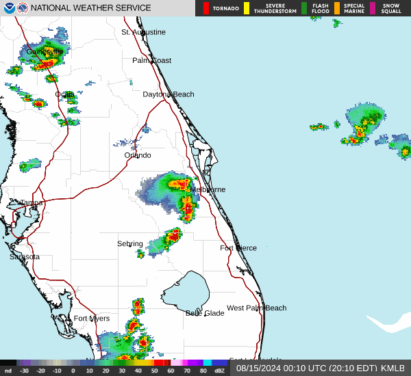
Current Radar Image
Sun Almanac for Leesburg, Florida
Sunrise: 06:46 AM
Sunset: 8:22 PM
Civil Sunrise:06:21 AM
Civil Sunset: 8:48 PM
Nautical Sunrise: 05:50 AM
Nautical Sunset: 9:18 PM
Astro Sunrise: 05:17 AM
Astro Sunset: 9:51 PM
Florida's Current Temperatures
 Florida's Satellite Image
 Florida's Current Wind Direction
| National Summary |
of upper and lower values of current conditions amongst 6924 locations
in the contiguous United States |
|
High
Temp |
108° |
Bullhead City, Arizona
|
|
Low
Temp |
41° |
Berthoud Pass, Colorado
|
|
Wind
Speed |
30mph |
Byron, California
|
|
Wind
Gust |
38mph |
Ely, Nevada
and 1 other location
|
|
Wind
Chill |
39° |
Salida Mountain, Colorado
|
|
High
Pressure |
30.69Hg |
Salida Mountain, Colorado
|
|
Low
Pressure |
29.63Hg |
Bullhead City, Arizona
|
|
| # Locations Reporting Rain |
30 |
|
| # Locations Reporting Thunderstorms / Lightning |
7 |
|
| # Locations Reporting Fog |
5 |
|
| Average Temperature in the Contiguous USA |
71° |
|
Any use of the information on this page is at your own risk. This information should not be relied upon in life-threatening situations, potential financial loss situations or in lieu of any officially disseminated information. Visit the
National Weather Service for official information.