Hobson, Idaho Weather
your sport, your way
Air Sports Net on FacebookAir Sports Net on Google +Air Sports Net on TwitterReceive RSS UpdatesReceive Email Updates

Change location by the zip code or city,state: or search for other weather forecast locations in Idaho by name.
Weather Forecast for Hobson, Idaho : Cassia County
Issued: 1:39 pm MDT May 2, 2024 Latitude: 42.531855 Longitude: -113.9239124 View on Google Maps

MouseOver for Detail Forecast
This Afternoon Tonight Friday Saturday Sunday Monday Tuesday Wednesday Thursday
60% chance of rain on This Afternoon 60% chance of rain on Tonight Mostly Cloudy on Friday Partly Sunny on Saturday 70% chance of rain on Sunday 30% chance of rain & snow on Monday 30% chance of rain & snow on Tuesday 20% chance of rain on Wednesday 20% chance of rain on Thursday
High: 53°F Low: 35°F High: 58°F High: 71°F High: 48°F High: 52°F High: 49°F High: 53°F High: 60°F
Low: 34°F Low: 37°F Low: 35°F Low: 35°F Low: 33°F Low: 32°F  
Rain Rain Mostly Cloudy Partly Sunny Rain Rain & Snow Rain & Snow Rain Rain
-
Current Conditions at
BURLEY - (KBYI)
43°
Cloudy
Light Rain
as of 3:53 PM MDST
Rel. Humidity: 70%
Dew Point: 34°F
Visibility: 5 Miles
Pressure: 29.94 in.
Flight Rule: MVFR
Wind Data
Calm
Cloud Level(s): Broken at 2300ft, Solid Overcast at 3100ft
Current Conditions at
TWIN FALLS - (KTWF)
45°
Cloudy
Light Rain
as of 3:53 PM MDST
Rel. Humidity: 70%
Dew Point: 36°F
Visibility: 5 Miles
Pressure: 29.93 in.
Flight Rule: MVFR
Wind Data
5 MPH
140° Southeast
Cloud Level(s): Broken at 3100ft, Solid Overcast at 4000ft
Current Conditions at
JEROME - (KJER)
46°
Cloudy
Light Rain
as of 3:53 PM MDST
Rel. Humidity: 52%
Dew Point: 30°F
Visibility: 10 Miles
Pressure: 29.93 in.
Flight Rule: VFR
Wind Data
6 MPH
Cloud Level(s): Solid Overcast at 4000ft
Current Conditions at
HAILEY - (KSUN)
39°
Cloudy
as of 3:55 PM MDST
Rel. Humidity: 80%
Dew Point: 34°F
Visibility: 10 Miles
Pressure: 29.96 in.
Flight Rule: VFR
Wind Data
Calm
Cloud Level(s): Scattered at 1800ft, Broken at 3500ft, Solid Overcast at 5000ft
60% chance of rain This Afternoon 
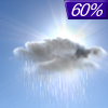
This Afternoon... Rain likely, mainly after 5pm. Mostly cloudy, with a high near 53. West southwest wind 11 to 13 mph, with gusts as high as 20 mph. Chance of precipitation is 60%.

60% chance of rain Tonight Tonight... Rain likely, mainly before 9pm. Cloudy, then gradually becoming partly cloudy, with a low around 35. West southwest wind 8 to 16 mph, with gusts as high as 24 mph. Chance of precipitation is 60%.

Mostly Cloudy on Friday Friday... Mostly cloudy, then gradually becoming sunny, with a high near 58. West wind 8 to 15 mph becoming south southeast in the afternoon. Winds could gust as high as 22 mph.

Mostly Clear on Friday Night Friday Night... Mostly clear, with a low around 34. East southeast wind 7 to 10 mph.

Partly Sunny on Saturday Saturday... Partly sunny, with a high near 71. Breezy, with an east wind 10 to 15 mph increasing to 18 to 23 mph in the afternoon. Winds could gust as high as 36 mph.

80% chance of rain Saturday Night Saturday Night... Showers. Low around 37. Breezy. Chance of precipitation is 80%.

70% chance of rain Sunday Sunday... Showers likely. Mostly cloudy, with a high near 48. Breezy. Chance of precipitation is 70%.

50% chance of rain & snow Sunday Night Sunday Night... A chance of rain showers before midnight, then a chance of rain and snow showers. Mostly cloudy, with a low around 35. Breezy. Chance of precipitation is 50%.

30% chance of rain & snow Monday Monday... A chance of rain and snow showers before 9am, then a chance of rain showers. Partly sunny, with a high near 52. Breezy. Chance of precipitation is 30%.

20% chance of rain Monday Night Monday Night... A 20 percent chance of showers after midnight. Mostly cloudy, with a low around 35. Breezy.

30% chance of rain & snow Tuesday Tuesday... A chance of rain and snow showers. Mostly sunny, with a high near 49. Breezy. Chance of precipitation is 30%.

Cloudy on Tuesday Night Tuesday Night... Partly cloudy, with a low around 33. Breezy.

20% chance of rain Wednesday Wednesday... A 20 percent chance of showers. Mostly sunny, with a high near 53.

Cloudy on Wednesday Night Wednesday Night... Partly cloudy, with a low around 32.

20% chance of rain Thursday Thursday... A 20 percent chance of showers. Mostly sunny, with a high near 60.

Current Radar Image


Sun Almanac for Hobson, Idaho
Sunrise: 06:28 AM
Sunset: 8:37 PM
Civil Sunrise:05:57 AM
Civil Sunset: 9:08 PM
Nautical Sunrise: 05:19 AM
Nautical Sunset: 9:46 PM
Astro Sunrise: 04:37 AM
Astro Sunset: 10:28 PM
Any use of the information on this page is at your own risk. This information should not be relied upon in life-threatening situations, potential financial loss situations or in lieu of any officially disseminated information. Visit the National Weather Service for official information.