No Watches or Warnings for Haggard
Issued: 4:29 pm CDT May 8, 2024 Latitude: 37.6344668 Longitude: -100.3204225 View on Google Maps
|
|
|
|
|
|
|
|
|
|
 |
 |
 |
|
 |
 |
 |
|
| Low: °F |
High: °F |
High: °F |
High: °F |
High: °F |
High: °F |
High: °F |
High: °F |
| Low: °F |
Low: °F |
Low: °F |
Low: °F |
Low: °F |
Low: °F |
|
| Increasing Clouds |
Partly Sunny |
Mostly Sunny |
Partly Sunny |
Thunderstorms |
Thunderstorms |
Thunderstorms |
Mostly Sunny |
Current Conditions at
DODGE CITY - (KDDC)
73°
Clear
as of 4:52 PM CDST
Rel. Humidity: 16%
Dew Point: 25°F
Visibility: 9 Miles
Pressure: 29.71 in.
Flight Rule: VFR
Wind Data
14 MPH
Gust: 26 MPH
300° Northwest
Cloud Level(s): Clear
Current Conditions at
GARDEN CITY - (KGCK)
70°
Clear
as of 4:54 PM CDST
Rel. Humidity: 15%
Dew Point: 21°F
Visibility: 10 Miles
Pressure: 29.73 in.
Flight Rule: VFR
Wind Data
12 MPH
Gust: 25 MPH
320° Northwest
Cloud Level(s): Clear
Current Conditions at
LIBERAL - (KLBL)
73°
Clear
as of 4:56 PM CDST
Rel. Humidity: 18%
Dew Point: 28°F
Visibility: 10 Miles
Pressure: 29.71 in.
Flight Rule: VFR
Wind Data
13 MPH
Gust: 17 MPH
070° East
Cloud Level(s): Clear
Current Conditions at
PRATT - (KPTT)
77°
Clear
as of 4:50 PM CDST
Rel. Humidity: 16%
Dew Point: 28°F
Visibility: 10 Miles
Pressure: 29.68 in.
Flight Rule: VFR
Wind Data
13 MPH
Gust: 17 MPH
350° North
Cloud Level(s): Clear
|
Tonight... Increasing clouds, with a low around 46. North northwest wind 7 to 10 mph becoming northeast after midnight. |
|
|
Thursday... Partly sunny, with a high near 72. North wind 10 to 15 mph. |
|
 |
Thursday Night... Mostly clear, with a low around 43. North wind 10 to 14 mph. |
|
|
Friday... Mostly sunny, with a high near 73. North wind around 10 mph. |
|
 |
Friday Night... Partly cloudy, with a low around 47. North wind 7 to 9 mph becoming east southeast after midnight. |
|
|
Saturday... Partly sunny, with a high near 77. |
|
 |
Saturday Night... A 50 percent chance of rain and thunderstorms. Mostly cloudy, with a low around 52. |
|
|
Sunday... A chance of rain and thunderstorms, then rain likely and possibly a thunderstorm after 1pm. Partly sunny, with a high near 74. Chance of precipitation is 60%. New rainfall amounts between a tenth and quarter of an inch, except higher amounts possible in thunderstorms. |
|
 |
Sunday Night... Rain and thunderstorms likely, mainly before 1am. Mostly cloudy, with a low around 50. Chance of precipitation is 60%. New rainfall amounts between a quarter and half of an inch possible. |
|
|
Monday... A 40 percent chance of rain and thunderstorms. Mostly sunny, with a high near 76. |
|
 |
Monday Night... A 20 percent chance of rain and thunderstorms. Partly cloudy, with a low around 50. |
|
|
Tuesday... A 20 percent chance of rain and thunderstorms. Mostly sunny, with a high near 81. |
|
|
Tuesday Night... A 20 percent chance of rain and thunderstorms. Partly cloudy, with a low around 52. |
|
|
Wednesday... Mostly sunny, with a high near 81. |
|
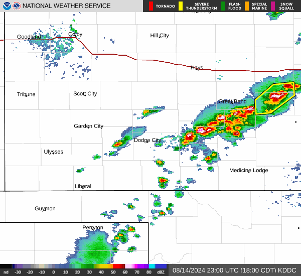
Current Radar Image
Sun Almanac for Haggard, Kansas
Sunrise: 06:37 AM
Sunset: 8:38 PM
Civil Sunrise:06:09 AM
Civil Sunset: 9:07 PM
Nautical Sunrise: 05:33 AM
Nautical Sunset: 9:42 PM
Astro Sunrise: 04:56 AM
Astro Sunset: 10:20 PM
Kansas' Current Temperatures
 Kansas' Satellite Image
 Kansas' Current Wind Direction
| National Summary |
of upper and lower values of current conditions amongst 5194 locations
in the contiguous United States |
|
High
Temp |
106° |
Zapata Cnty A/P, Texas
|
|
Low
Temp |
32° |
Pagosa Springs, Colorado
and 1 other location
|
|
Wind
Speed |
33mph |
Cowley, Wyoming
|
|
Wind
Gust |
46mph |
Buffalo, Wyoming
|
|
Wind
Chill |
22° |
Pagosa Springs, Colorado
|
|
Heat
Index |
113° |
Edinburg Intl Arpt, Texas
and 1 other location
|
|
High
Pressure |
30.55Hg |
Ottawa, Ohio
|
|
Low
Pressure |
29.48Hg |
Claremore Rgnl Arpt, Oklahoma
and 1 other location
|
|
| # Locations Reporting Snow |
2 |
|
| # Locations Reporting Rain |
73 |
|
| # Locations Reporting Thunderstorms / Lightning |
25 |
|
| # Locations Reporting Fog |
1 |
|
| Average Temperature in the Contiguous USA |
74° |
|
Any use of the information on this page is at your own risk. This information should not be relied upon in life-threatening situations, potential financial loss situations or in lieu of any officially disseminated information. Visit the
National Weather Service for official information.