No Watches or Warnings for Bracey
Issued: 10:16 am EDT May 4, 2024 Latitude: 36.599589 Longitude: -78.1430505 View on Google Maps
|
|
|
|
|
|
|
|
|
|
 |
 |
 |
 |
 |
 |
 |
 |
| High: °F |
Low: °F |
High: °F |
High: °F |
High: °F |
High: °F |
High: °F |
High: °F |
| Low: °F |
Low: °F |
Low: °F |
Low: °F |
Low: °F |
|
| Thunderstorms |
Thunderstorms |
Thunderstorms |
Thunderstorms |
Thunderstorms |
Mostly Sunny |
Thunderstorms |
Thunderstorms |
Current Conditions at
MECKLENBURG-BRUNSWIC - (KAVC)
61°
Cloudy
as of 1:55 PM EDST
Rel. Humidity: 100%
Dew Point: 61°F
Visibility: 3 Miles
Pressure: 30.22 in.
Flight Rule: LIFR
Wind Data
3 MPH
040° Northeast
Cloud Level(s): Solid Overcast at 300ft
Current Conditions at
ROANOKE RAPIDS REG - (KIXA)
68°
Cloudy
as of 1:55 PM EDST
Rel. Humidity: 93%
Dew Point: 66°F
Visibility: 10 Miles
Pressure: 30.15 in.
Flight Rule: MVFR
Wind Data
5 MPH
050° Northeast
Cloud Level(s): Solid Overcast at 1600ft
Current Conditions at
ROXBORO - (KTDF)
59°
Cloudy
Mist
as of 1:45 PM EDST
Rel. Humidity: 100%
Dew Point: 59°F
Visibility: 3 Miles
Pressure: 30.17 in.
Flight Rule: LIFR
Wind Data
7 MPH
060° Northeast
Cloud Level(s): Solid Overcast at 200ft
|
This Afternoon... A chance of showers, with thunderstorms also possible after 4pm. Cloudy, with a high near 73. East wind around 6 mph. Chance of precipitation is 40%. New rainfall amounts between a tenth and quarter of an inch, except higher amounts possible in thunderstorms. |
|
|
Tonight... Showers and thunderstorms. Low around 63. Northeast wind around 6 mph becoming southeast after midnight. Chance of precipitation is 80%. New precipitation amounts between a half and three quarters of an inch possible. |
|
|
Sunday... A chance of showers, then showers likely and possibly a thunderstorm after 2pm. Mostly cloudy, with a high near 77. South wind 5 to 8 mph. Chance of precipitation is 60%. New rainfall amounts of less than a tenth of an inch, except higher amounts possible in thunderstorms. |
|
 |
Sunday Night... Showers likely and possibly a thunderstorm before 8pm, then a chance of showers. Mostly cloudy, with a low around 64. South wind around 6 mph becoming calm. Chance of precipitation is 60%. New precipitation amounts of less than a tenth of an inch, except higher amounts possible in thunderstorms. |
|
|
Monday... A slight chance of showers, then showers likely and possibly a thunderstorm after 2pm. Mostly cloudy, with a high near 82. Light south wind becoming southwest 5 to 9 mph in the morning. Chance of precipitation is 70%. New rainfall amounts between a tenth and quarter of an inch, except higher amounts possible in thunderstorms. |
|
|
Monday Night... Showers likely and possibly a thunderstorm before 8pm, then a chance of showers and thunderstorms, mainly between 8pm and 2am. Mostly cloudy, with a low around 65. Chance of precipitation is 60%. New rainfall amounts between a tenth and quarter of an inch, except higher amounts possible in thunderstorms. |
|
|
Tuesday... A chance of showers and thunderstorms after 2pm. Partly sunny, with a high near 84. Chance of precipitation is 40%. |
|
 |
Tuesday Night... A chance of showers and thunderstorms before 8pm. Partly cloudy, with a low around 65. Chance of precipitation is 30%. |
|
|
Wednesday... Mostly sunny, with a high near 90. |
|
|
Wednesday Night... A chance of showers and thunderstorms between 8pm and 2am. Partly cloudy, with a low around 68. Chance of precipitation is 30%. |
|
|
Thursday... A chance of showers and thunderstorms. Mostly sunny, with a high near 90. Chance of precipitation is 40%. |
|
 |
Thursday Night... A chance of showers and thunderstorms. Mostly cloudy, with a low around 65. Chance of precipitation is 30%. |
|
|
Friday... A chance of showers and thunderstorms. Partly sunny, with a high near 84. Chance of precipitation is 50%. |
|
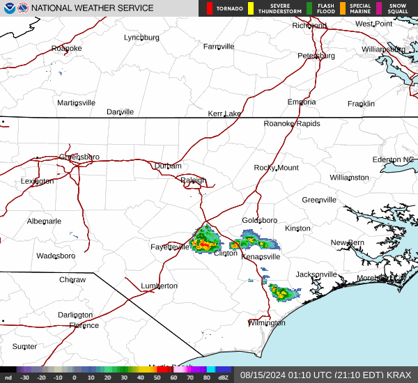
Current Radar Image
Sun Almanac for Bracey, Virginia
Sunrise: 06:15 AM
Sunset: 8:04 PM
Civil Sunrise:05:47 AM
Civil Sunset: 8:32 PM
Nautical Sunrise: 05:13 AM
Nautical Sunset: 9:06 PM
Astro Sunrise: 04:37 AM
Astro Sunset: 9:42 PM
Virginia's Current Temperatures
 Virginia's Satellite Image
 Virginia's Current Wind Direction
| National Summary |
of upper and lower values of current conditions amongst 6951 locations
in the contiguous United States |
|
High
Temp |
93° |
Plant City Municipal A/P, Florida
|
|
Low
Temp |
32° |
Berthoud Pass, Colorado
|
|
Wind
Speed |
37mph |
Reno, Nevada
|
|
Wind
Gust |
51mph |
Eureka, Nevada
|
|
Wind
Chill |
20° |
Berthoud Pass, Colorado
|
|
Heat
Index |
102° |
Ft Rucker/Hanche, Alabama
|
|
High
Pressure |
30.40Hg |
Portland, Maine
|
|
Low
Pressure |
29.45Hg |
Bend Municipal A/P, Oregon
|
|
| # Locations Reporting Snow |
2 |
|
| # Locations Reporting Rain |
209 |
|
| # Locations Reporting Thunderstorms / Lightning |
25 |
|
| # Locations Reporting Fog |
6 |
|
| Average Temperature in the Contiguous USA |
66° |
|
Any use of the information on this page is at your own risk. This information should not be relied upon in life-threatening situations, potential financial loss situations or in lieu of any officially disseminated information. Visit the
National Weather Service for official information.