Alvarado, Indiana Weather
Issued: 3:32 am EST Dec 15, 2025 Latitude: 41.5767171 Longitude: -84.8377368 View on Google Maps
|
|
|
|
|
|
|
|
|
|
 |
 |
 |
 |
 |
 |
 |
 |
| Low: °F |
High: °F |
High: °F |
High: °F |
High: °F |
High: °F |
High: °F |
High: °F |
| Low: °F |
Low: °F |
Low: °F |
Low: °F |
Low: °F |
Low: °F |
|
| Mostly Cloudy |
Blowing Snow |
Mostly Sunny |
Partly Sunny |
Rain |
Mostly Cloudy |
Rain |
Rain |
Current Conditions at
DEFIANCE - (KDFI)
9°
Clear
as of 2:53 AM EST
Rel. Humidity: 78%
Dew Point: 3°F
Visibility: 10 Miles
Pressure: 30.49 in.
Flight Rule: VFR
Wind Data
6 MPH
220° Southwest
Cloud Level(s): Clear
Current Conditions at
COLDWATER - (KOEB)
Cloudy
as of 3:36 AM EST
Rel. Humidity: 85%
Dew Point: 9°F
Visibility: 10 Miles
Pressure: 30.44 in.
Flight Rule: IFR
Wind Data
12 MPH
230° Southwest
Cloud Level(s): Solid Overcast at 900ft
Current Conditions at
HILLSDALE - (KJYM)
12°
Cloudy
as of 3:35 AM EST
Rel. Humidity: 85%
Dew Point: 9°F
Visibility: 10 Miles
Pressure: 30.41 in.
Flight Rule: MVFR
Cloud Level(s): Solid Overcast at 1000ft
Current Conditions at
STURGIS - (KIRS)
Partly Cloudy
as of 3:35 AM EST
Rel. Humidity: 78%
Dew Point: 5°F
Visibility: 10 Miles
Pressure: 30.45 in.
Flight Rule: VFR
Wind Data
10 MPH
230° Southwest
Cloud Level(s): Few at 1300ft, Scattered at 12000ft
|
Overnight... Mostly cloudy, with a low around 6. Wind chill values as low as -10. Southwest wind around 10 mph. |
|
|
Monday... Patchy blowing snow after 9am. Partly sunny and cold, with a high near 19. Wind chill values as low as -10. Southwest wind 10 to 15 mph, with gusts as high as 30 mph. |
|
 |
Monday Night... Partly cloudy, with a low around 10. West wind 5 to 10 mph, with gusts as high as 20 mph. |
|
|
Tuesday... Mostly sunny, with a high near 33. South wind 5 to 10 mph, with gusts as high as 20 mph. |
|
|
Tuesday Night... Mostly cloudy, with a low around 27. Southwest wind 10 to 15 mph, with gusts as high as 25 mph. |
|
|
Wednesday... Partly sunny, with a high near 37. |
|
 |
Wednesday Night... A 30 percent chance of rain after 1am. Mostly cloudy, with a low around 27. |
|
|
Thursday... Rain. High near 46. Chance of precipitation is 90%. |
|
 |
Thursday Night... A chance of rain and snow before 1am, then a slight chance of snow. Mostly cloudy, with a low around 17. Chance of precipitation is 40%. |
|
|
Friday... Mostly cloudy, with a high near 27. |
|
|
Friday Night... Mostly cloudy, with a low around 20. |
|
|
Saturday... A 20 percent chance of rain. Mostly cloudy, with a high near 41. |
|
 |
Saturday Night... A chance of rain. Mostly cloudy, with a low around 27. |
|
|
Sunday... A slight chance of rain. Partly sunny, with a high near 36. |
|
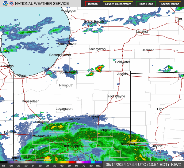
Current Radar Image
Sun Almanac for Alvarado, Indiana
Sunrise: 07:59 AM
Sunset: 5:10 PM
Civil Sunrise:07:28 AM
Civil Sunset: 5:42 PM
Nautical Sunrise: 06:53 AM
Nautical Sunset: 6:16 PM
Astro Sunrise: 06:19 AM
Astro Sunset: 6:50 PM
Indiana's Current Temperatures
 Indiana's Satellite Image
 Indiana's Current Wind Direction
| National Summary |
of upper and lower values of current conditions amongst 7101 locations
in the contiguous United States |
|
High
Temp |
72° |
Key West Intl, Florida
and 2 other locations
|
|
Low
Temp |
-9° |
Terre Haute, Indiana
and 2 other locations
|
|
Wind
Speed |
35mph |
Whidbey IsNAS, Washington
|
|
Wind
Gust |
52mph |
Whidbey IsNAS, Washington
|
|
Wind
Chill |
-23° |
Bloomington, Illinois
|
|
High
Pressure |
30.63Hg |
Newport Municipal A/P, Arkansas
and 1 other location
|
|
Low
Pressure |
29.73Hg |
Frenchville, Maine
and 2 other locations
|
|
| # Locations Reporting Snow |
50 |
|
| # Locations Reporting Rain |
19 |
|
| # Locations Reporting Fog |
25 |
|
| Average Temperature in the Contiguous USA |
24° |
|
Any use of the information on this page is at your own risk. This information should not be relied upon in life-threatening situations, potential financial loss situations or in lieu of any officially disseminated information. Visit the
National Weather Service for official information.