Pierce, North Dakota Weather
No Watches or Warnings for Pierce
Issued: 9:50 pm MDT May 7, 2024 Latitude: 46.3522312 Longitude: -103.0712797 View on Google Maps
|
|
|
|
|
|
|
|
|
|
 |
 |
 |
 |
|
|
|
 |
| Low: °F |
High: °F |
High: °F |
High: °F |
High: °F |
High: °F |
High: °F |
High: °F |
| Low: °F |
Low: °F |
Low: °F |
Low: °F |
Low: °F |
Low: °F |
|
| Rain |
Rain |
Partly Sunny |
Sunny |
Sunny |
Sunny |
Sunny |
Mostly Sunny |
Current Conditions at
HETTINGER - (KHEI)
Cloudy
Light Rain
as of 9:53 PM MDST
Rel. Humidity: 93%
Dew Point: 39°F
Visibility: 10 Miles
Pressure: 29.32 in.
Flight Rule: VFR
Cloud Level(s): Solid Overcast at 3200ft
Current Conditions at
DICKINSON - (KDIK)
Cloudy
as of 9:56 PM MDST
Rel. Humidity: 100%
Dew Point: 43°F
Visibility: 10 Miles
Pressure: 29.25 in.
Flight Rule: MVFR
Cloud Level(s): Solid Overcast at 1600ft
Current Conditions at
BAKER - (KBHK)
Cloudy
Light Rain
as of 9:51 PM MDST
Rel. Humidity: 100%
Dew Point: 39°F
Visibility: 10 Miles
Pressure: 29.33 in.
Flight Rule: VFR
Cloud Level(s): Few at 600ft, Scattered at 2500ft, Solid Overcast at 3200ft
Current Conditions at
BUFFALO - (K2WX)
Cloudy
as of 9:56 PM MDST
Rel. Humidity: 75%
Dew Point: 36°F
Pressure: 29.31 in.
Wind Data
24 MPH
Gust: 32 MPH
270° West
|
Tonight... Scattered showers, mainly before 5am. Cloudy, with a low around 38. West wind 9 to 16 mph becoming northeast after midnight. Winds could gust as high as 28 mph. Chance of precipitation is 50%. |
|
|
Wednesday... Scattered showers, mainly after 11am. Mostly cloudy, with a high near 56. Northeast wind 13 to 18 mph, with gusts as high as 25 mph. Chance of precipitation is 30%. |
|
 |
Wednesday Night... Scattered showers, mainly before midnight. Mostly cloudy, with a low around 40. North wind 9 to 17 mph, with gusts as high as 23 mph. Chance of precipitation is 50%. |
|
|
Thursday... A 20 percent chance of showers. Partly sunny, with a high near 66. North wind 9 to 18 mph, with gusts as high as 28 mph. |
|
 |
Thursday Night... Partly cloudy, with a low around 42. Northwest wind 11 to 18 mph, with gusts as high as 28 mph. |
|
|
Friday... Sunny, with a high near 67. Windy, with a northwest wind 11 to 16 mph increasing to 20 to 25 mph in the morning. Winds could gust as high as 33 mph. |
|
 |
Friday Night... Mostly clear, with a low around 43. Breezy, with a west wind 17 to 22 mph decreasing to 9 to 14 mph after midnight. Winds could gust as high as 29 mph. |
|
|
Saturday... Sunny, with a high near 75. West wind 10 to 16 mph, with gusts as high as 23 mph. |
|
|
Saturday Night... Mostly clear, with a low around 47. West wind 9 to 15 mph, with gusts as high as 21 mph. |
|
|
Sunday... Sunny, with a high near 76. Northwest wind 9 to 14 mph, with gusts as high as 21 mph. |
|
|
Sunday Night... Mostly clear, with a low around 47. North wind 10 to 13 mph becoming south after midnight. Winds could gust as high as 18 mph. |
|
|
Monday... Sunny, with a high near 77. South wind 13 to 17 mph becoming west in the afternoon. Winds could gust as high as 25 mph. |
|
|
Monday Night... Partly cloudy, with a low around 49. West wind 11 to 15 mph becoming south in the evening. Winds could gust as high as 23 mph. |
|
|
Tuesday... Mostly sunny, with a high near 75. |
|
Current Radar Image
Sun Almanac for Pierce, North Dakota
Sunrise: 05:27 AM
Sunset: 8:11 PM
Civil Sunrise:04:52 AM
Civil Sunset: 8:45 PM
Nautical Sunrise: 04:08 AM
Nautical Sunset: 9:29 PM
Astro Sunrise: 03:17 AM
Astro Sunset: 10:20 PM
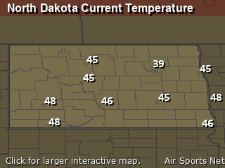
North Dakota's Current Temperatures
 North Dakota's Satellite Image
 North Dakota's Current Wind Direction
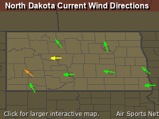
| National Summary |
of upper and lower values of current conditions amongst 6950 locations
in the contiguous United States |
|
High
Temp |
86° |
Bullhead City, Arizona
and 1 other location
|
|
Low
Temp |
30° |
Pinedale, Wyoming
and 10 other locations
|
|
Wind
Speed |
49mph |
Charlie, Montana
|
|
Wind
Gust |
64mph |
Charlie, Montana
|
|
Wind
Chill |
16° |
Dubois Municipal, Wyoming
and 2 other locations
|
|
High
Pressure |
30.39Hg |
Tillamook A/P, Oregon
and 1 other location
|
|
Low
Pressure |
29.25Hg |
Dickinson, North Dakota
|
|
| # Locations Reporting Snow |
18 |
|
| # Locations Reporting Rain |
76 |
|
| # Locations Reporting Thunderstorms / Lightning |
17 |
|
| # Locations Reporting Fog |
9 |
|
| Average Temperature in the Contiguous USA |
62° |
|
Any use of the information on this page is at your own risk. This information should not be relied upon in life-threatening situations, potential financial loss situations or in lieu of any officially disseminated information. Visit the
National Weather Service for official information.


