Hillcrest, Mississippi Weather
Current Conditions at
COLUMBUS AFB - (KCBM)
46°
Clear
as of 3:55 AM CDST
Rel. Humidity: 93%
Dew Point: 45°F
Visibility: 10 Miles
Pressure: 30.23 in.
Flight Rule: VFR
Cloud Level(s): Clear
Current Conditions at
COLUMBUS ARPT - (KGTR)
48°
Clear
as of 3:56 AM CDST
Rel. Humidity: 100%
Dew Point: 48°F
Visibility: 10 Miles
Pressure: 30.27 in.
Flight Rule: VFR
Cloud Level(s): Clear
Current Conditions at
TUPELO - (KTUP)
48°
Clear
as of 3:53 AM CDST
Rel. Humidity: 100%
Dew Point: 48°F
Visibility: 10 Miles
Pressure: 30.26 in.
Flight Rule: VFR
Cloud Level(s): Clear
Current Conditions at
TUSCALOOSA - (KTCL)
48°
Clear
as of 3:53 AM CDST
Rel. Humidity: 93%
Dew Point: 46°F
Visibility: 9 Miles
Pressure: 30.28 in.
Flight Rule: VFR
Cloud Level(s): Clear
Moon Almanac for Hillcrest, Mississippi
Moon Phase: Waxing Crescent
Moon Illumination: 21%
Moon Age: 4.43 Days
Moon is currently below the horizon
Distance from Moon to Earth: 225,955 miles
Upcoming Lunar Events for
Hillcrest: |
| Next Event | Event Time | Illum |
|
|
|
| Moonrise: | 10:25 am Tue | 22.7% |
| High Moon: | 06:08 pm Tue | 26.0% |
| Moonset: | 01:49 am Wed | 29.3% |
 | New Moon: Fri Apr 17 |
 | First Quarter: Thu Apr 23 |
 | Full Moon: Fri May 1 |
 | Last Quarter: Sat May 9 |
| New Moon: Sat May 16 |
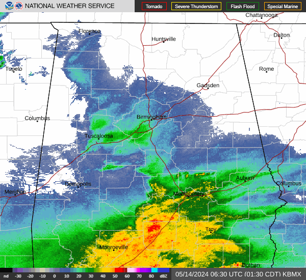
Current Radar Image
| Mississippi State Summary |
of upper and lower values of current conditions amongst 30 locations
in Mississippi |
|
|
|
|
|
Wind
Speed |
7mph |
Olive Branch Airprt
|
|
High
Pressure |
30.28Hg |
Aberdeen/Amory
|
|
Low
Pressure |
30.20Hg |
Biloxi
|
|
| Average temperature in Mississippi |
47° |
|
| # Locations Reporting Rain |
1 |
|
# Locations Reporting MVFR
(Marginal Visual Flight Rules) |
1 |
|
# Locations Reporting VFR
(Visual Flight Rules) |
29 |
|
Mississippi's Current Temperatures
 Mississippi's Satellite Image
 Mississippi's Current Wind Direction
| National Summary |
of upper and lower values of current conditions amongst 6373 locations
in the contiguous United States |
|
High
Temp |
79° |
Phoenix, Arizona
and 2 other locations
|
|
Low
Temp |
12° |
Clayton Lake, Maine
|
|
Wind
Speed |
28mph |
Miss Canyan 807, Louisiana
and 1 other location
|
|
Wind
Gust |
37mph |
Pompano Beach, Florida
|
|
Wind
Chill |
21° |
Erie, Pennsylvania
and 1 other location
|
|
High
Pressure |
30.52Hg |
Salida Mountain, Colorado
|
|
Low
Pressure |
29.67Hg |
Yagabond Aaf, Washington
|
|
| # Locations Reporting Rain |
71 |
|
| # Locations Reporting Thunderstorms / Lightning |
4 |
|
| # Locations Reporting Fog |
2 |
|
| Average Temperature in the Contiguous USA |
47° |
|
Any use of the information on this page is at your own risk. This information should not be relied upon in life-threatening situations, potential financial loss situations or in lieu of any officially disseminated information. Visit the
National Weather Service for official information.