Ellinwood, Kansas Weather
Issued: 3:44 pm CDT May 1, 2024 Latitude: 38.3555675 Longitude: -98.5809106 View on Google Maps
|
|
|
|
|
|
|
|
|
|
|
 |
 |
 |
 |
 |
 |
 |
 |
|
| High: °F |
Low: °F |
High: °F |
High: °F |
High: °F |
High: °F |
High: °F |
High: °F |
High: °F |
| Low: °F |
Low: °F |
Low: °F |
Low: °F |
Low: °F |
Low: °F |
|
| Thunderstorms |
Thunderstorms |
Thunderstorms |
Mostly Sunny |
Thunderstorms |
Thunderstorms |
Thunderstorms |
Sunny |
Sunny |
Current Conditions at
GREAT BEND - (KGBD)
81°
Cloudy
as of 4:56 PM CDST
Rel. Humidity: 54%
Dew Point: 63°F
Visibility: 10 Miles
Pressure: 29.71 in.
Flight Rule: VFR
Wind Data
24 MPH
Gust: 30 MPH
150° Southeast
Cloud Level(s): Broken at 4000ft, Broken at 4900ft, Solid Overcast at 6500ft
Current Conditions at
RUSSELL - (KRSL)
70°
Cloudy
as of 4:53 PM CDST
Rel. Humidity: 64%
Dew Point: 57°F
Visibility: 10 Miles
Pressure: 29.71 in.
Flight Rule: VFR
Wind Data
16 MPH
Gust: 25 MPH
090° East
Cloud Level(s): Solid Overcast at 3300ft
Current Conditions at
HUTCHINSON - (KHUT)
77°
Cloudy
as of 4:52 PM CDST
Rel. Humidity: 57%
Dew Point: 61°F
Visibility: 10 Miles
Pressure: 29.74 in.
Flight Rule: VFR
Wind Data
23 MPH
160° South
Cloud Level(s): Broken at 4300ft, Solid Overcast at 6000ft
Current Conditions at
PRATT - (KPTT)
77°
Clear
as of 4:50 PM CDST
Rel. Humidity: 57%
Dew Point: 61°F
Visibility: 10 Miles
Pressure: 29.73 in.
Flight Rule: VFR
Wind Data
18 MPH
Gust: 28 MPH
160° South
Cloud Level(s): Clear
|
This Afternoon... A 20 percent chance of showers and thunderstorms. Some of the storms could be severe. Mostly cloudy, with a high near 74. Southeast wind around 16 mph, with gusts as high as 24 mph. |
|
|
Tonight... A 40 percent chance of showers and thunderstorms. Some of the storms could be severe. Mostly cloudy, with a low around 54. Southeast wind 14 to 18 mph becoming southwest after midnight. Winds could gust as high as 28 mph. |
|
|
Thursday... A chance of showers and thunderstorms before 1pm, then a slight chance of showers and thunderstorms after 4pm. Mostly cloudy, then gradually becoming sunny, with a high near 69. North wind 11 to 17 mph, with gusts as high as 26 mph. Chance of precipitation is 40%. |
|
 |
Thursday Night... A 10 percent chance of showers and thunderstorms before 7pm. Mostly clear, with a low around 45. Northeast wind 9 to 14 mph, with gusts as high as 20 mph. |
|
|
Friday... Mostly sunny, with a high near 72. Northeast wind 8 to 15 mph becoming east southeast in the afternoon. Winds could gust as high as 23 mph. |
|
 |
Friday Night... A slight chance of showers and thunderstorms, then showers likely and possibly a thunderstorm after 1am. Mostly cloudy, with a low around 50. Chance of precipitation is 70%. |
|
|
Saturday... A chance of showers and thunderstorms before 1pm, then a slight chance of showers. Partly sunny, with a high near 69. Chance of precipitation is 40%. |
|
|
Saturday Night... A 40 percent chance of showers and thunderstorms, mainly after 1am. Mostly cloudy, with a low around 50. |
|
|
Sunday... A 50 percent chance of showers and thunderstorms. Partly sunny, with a high near 72. |
|
 |
Sunday Night... A 20 percent chance of showers and thunderstorms after 1am. Mostly cloudy, with a low around 57. |
|
|
Monday... A 20 percent chance of showers and thunderstorms. Partly sunny, with a high near 80. Breezy. |
|
 |
Monday Night... Mostly clear, with a low around 50. Breezy. |
|
|
Tuesday... Sunny, with a high near 80. Breezy. |
|
|
Tuesday Night... Mostly clear, with a low around 50. |
|
|
Wednesday... Sunny, with a high near 79. |
|
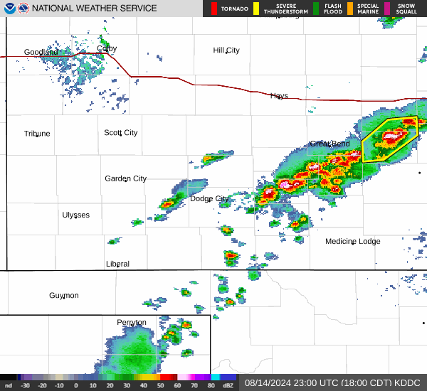
Current Radar Image
Sun Almanac for Ellinwood, Kansas
Sunrise: 06:36 AM
Sunset: 8:26 PM
Civil Sunrise:06:08 AM
Civil Sunset: 8:55 PM
Nautical Sunrise: 05:33 AM
Nautical Sunset: 9:29 PM
Astro Sunrise: 04:56 AM
Astro Sunset: 10:07 PM
Kansas' Current Temperatures
 Kansas' Satellite Image
 Kansas' Current Wind Direction
| National Summary |
of upper and lower values of current conditions amongst 5145 locations
in the contiguous United States |
|
High
Temp |
95° |
Presidio, Texas
and 1 other location
|
|
Low
Temp |
30° |
Jackson, Wyoming
and 3 other locations
|
|
Wind
Speed |
35mph |
Pampa, Texas
and 1 other location
|
|
Wind
Gust |
48mph |
Salida Mountain, Colorado
|
|
Wind
Chill |
19° |
Dubois Municipal, Wyoming
and 1 other location
|
|
Heat
Index |
121° |
Clarksdale/Fletcher, Mississippi
|
|
High
Pressure |
30.22Hg |
Newport, Oregon
|
|
Low
Pressure |
29.63Hg |
Pecos, Texas
and 1 other location
|
|
| # Locations Reporting Snow |
7 |
|
| # Locations Reporting Rain |
22 |
|
| # Locations Reporting Thunderstorms / Lightning |
8 |
|
| # Locations Reporting Fog |
1 |
|
| Average Temperature in the Contiguous USA |
72° |
|
Any use of the information on this page is at your own risk. This information should not be relied upon in life-threatening situations, potential financial loss situations or in lieu of any officially disseminated information. Visit the
National Weather Service for official information.