Waltersburg, Illinois Weather
Issued: 5:48 pm CDT Apr 23, 2024 Latitude: 37.378941 Longitude: -88.5642136 View on Google Maps
|
|
|
|
|
|
|
|
|
|
 |
 |
 |
 |
 |
|
 |
 |
| Low: °F |
High: °F |
High: °F |
High: °F |
High: °F |
High: °F |
High: °F |
High: °F |
| Low: °F |
Low: °F |
Low: °F |
Low: °F |
Low: °F |
Low: °F |
|
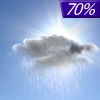
| Rain |
Sunny |
Increasing Clouds |
Thunderstorms |
Thunderstorms |
Thunderstorms |
Thunderstorms |
Rain |
Current Conditions at
METROPOLIS MUNI ARP - (KM30)
70°
Cloudy
as of 7:35 PM CDST
Rel. Humidity: 40%
Dew Point: 45°F
Visibility: 10 Miles
Pressure: 29.94 in.
Flight Rule: VFR
Wind Data
10 MPH
Gust: 16 MPH
200° South
Cloud Level(s): Solid Overcast at 7000ft
Current Conditions at
PADUCAH - (KPAH)
72°
Mostly Cloudy
as of 6:53 PM CDST
Rel. Humidity: 35%
Dew Point: 43°F
Visibility: 10 Miles
Pressure: 29.92 in.
Flight Rule: VFR
Wind Data
8 MPH
Gust: 20 MPH
220° Southwest
Cloud Level(s): Broken at 9000ft, Broken at 11000ft
Current Conditions at
MARION - (KMWA)
59°
Cloudy
as of 7:35 PM CDST
Rel. Humidity: 77%
Dew Point: 52°F
Visibility: 10 Miles
Pressure: 29.95 in.
Flight Rule: VFR
Cloud Level(s): Scattered at 6000ft, Solid Overcast at 10000ft
|
Tonight... Showers likely, mainly before midnight. Cloudy, then gradually becoming partly cloudy, with a low around 49. Southwest wind 6 to 15 mph becoming northwest in the evening. Winds could gust as high as 23 mph. Chance of precipitation is 70%. |
|
|
Wednesday... Sunny, with a high near 70. North wind 6 to 9 mph. |
|
 |
Wednesday Night... Mostly clear, with a low around 44. Northeast wind 6 to 8 mph. |
|
|
Thursday... Increasing clouds, with a high near 70. East southeast wind 6 to 8 mph. |
|
 |
Thursday Night... A chance of showers, with thunderstorms also possible after 4am. Mostly cloudy, with a low around 53. East wind 6 to 9 mph. Chance of precipitation is 40%. |
|
|
Friday... A 50 percent chance of showers and thunderstorms. Mostly cloudy, with a high near 78. Breezy, with a south wind 11 to 16 mph increasing to 17 to 22 mph in the afternoon. Winds could gust as high as 33 mph. |
|
 |
Friday Night... A 50 percent chance of showers and thunderstorms. Mostly cloudy, with a low around 65. Breezy, with a south wind 21 to 24 mph, with gusts as high as 37 mph. |
|
|
Saturday... A chance of showers and thunderstorms. Partly sunny, with a high near 81. Breezy, with a south wind 21 to 24 mph, with gusts as high as 37 mph. |
|
 |
Saturday Night... A slight chance of showers and thunderstorms. Partly cloudy, with a low around 67. Breezy, with a south wind 18 to 21 mph, with gusts as high as 31 mph. |
|
|
Sunday... A slight chance of showers, then a chance of showers and thunderstorms after 1pm. Partly sunny, with a high near 82. Breezy, with a south wind 21 to 24 mph, with gusts as high as 36 mph. |
|
 |
Sunday Night... Showers likely and possibly a thunderstorm. Mostly cloudy, with a low around 64. Breezy, with a south wind 18 to 21 mph, with gusts as high as 31 mph. |
|
|
Monday... Showers likely and possibly a thunderstorm. Mostly cloudy, with a high near 77. South southwest wind 15 to 18 mph, with gusts as high as 26 mph. |
|
 |
Monday Night... A chance of showers and thunderstorms. Partly cloudy, with a low around 56. South southwest wind 9 to 14 mph becoming west northwest after midnight. Winds could gust as high as 21 mph. |
|
|
Tuesday... A slight chance of showers. Mostly sunny, with a high near 77. West northwest wind 8 to 11 mph. |
|
Current Radar Image
Sun Almanac for Waltersburg, Illinois
Sunrise: 06:08 AM
Sunset: 7:37 PM
Civil Sunrise:05:40 AM
Civil Sunset: 8:05 PM
Nautical Sunrise: 05:07 AM
Nautical Sunset: 8:38 PM
Astro Sunrise: 04:32 AM
Astro Sunset: 9:12 PM
Illinois' Current Temperatures
 Illinois' Satellite Image
 Illinois' Current Wind Direction
| National Summary |
of upper and lower values of current conditions amongst 6957 locations
in the contiguous United States |
|
High
Temp |
97° |
Gila Bend (Aaf), Arizona
|
|
Low
Temp |
30° |
Berthoud Pass, Colorado
|
|
Wind
Speed |
33mph |
Salida Mountain, Colorado
|
|
Wind
Gust |
52mph |
Salida Mountain, Colorado
|
|
Wind
Chill |
20° |
Gwinn, Michigan
|
|
High
Pressure |
30.43Hg |
Salida Mountain, Colorado
|
|
Low
Pressure |
29.69Hg |
Alpena, Michigan
|
|
| # Locations Reporting Snow |
1 |
|
| # Locations Reporting Rain |
78 |
|
| # Locations Reporting Thunderstorms / Lightning |
3 |
|
| Average Temperature in the Contiguous USA |
64° |
|
Any use of the information on this page is at your own risk. This information should not be relied upon in life-threatening situations, potential financial loss situations or in lieu of any officially disseminated information. Visit the
National Weather Service for official information.


