Purcell, Pennsylvania Weather
No Watches or Warnings for Purcell
Issued: 7:00 pm EDT Apr 18, 2024 Latitude: 39.7884209 Longitude: -78.3672355 View on Google Maps
|
|
|
|
|
|
|
|
|
|
 |
 |
 |
 |
 |
|
 |
|
| Low: °F |
High: °F |
High: °F |
High: °F |
High: °F |
High: °F |
High: °F |
High: °F |
| Low: °F |
Low: °F |
Low: °F |
Low: °F |
Low: °F |
Low: °F |
|
| Increasing Clouds |
Rain |
Mostly Sunny |
Partly Sunny |
Sunny |
Mostly Sunny |
Rain |
Sunny |
Current Conditions at
GREATER CUMBERLAND ARPT - (KCBE)
68°
Clear
as of 8:05 PM EDST
Rel. Humidity: 40%
Dew Point: 43°F
Visibility: 10 Miles
Pressure: 30.07 in.
Flight Rule: VFR
Cloud Level(s): Clear
Current Conditions at
MARTINSBURG - (KMRB)
66°
Clear
as of 7:53 PM EDST
Rel. Humidity: 52%
Dew Point: 48°F
Visibility: 10 Miles
Pressure: 30.01 in.
Flight Rule: VFR
Wind Data
3 MPH
060° Northeast
Cloud Level(s): Clear
Current Conditions at
HAGERSTOWN - (KHGR)
70°
Clear
as of 7:53 PM EDST
Rel. Humidity: 46%
Dew Point: 48°F
Visibility: 10 Miles
Pressure: 30.02 in.
Flight Rule: VFR
Cloud Level(s): Clear
Current Conditions at
JOHNSTOWN - (KJST)
57°
Clear
as of 7:54 PM EDST
Rel. Humidity: 62%
Dew Point: 45°F
Visibility: 10 Miles
Pressure: 30.07 in.
Flight Rule: VFR
Cloud Level(s): Clear
|
Tonight... Increasing clouds, with a low around 48. Calm wind becoming southeast 5 to 8 mph after midnight. |
|
|
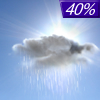
Friday... Showers likely, mainly after 1pm. Cloudy, with a high near 64. Southeast wind 8 to 10 mph. Chance of precipitation is 70%. New precipitation amounts of less than a tenth of an inch possible. |
|
 |
Friday Night... A chance of showers, mainly before 11pm. Cloudy, then gradually becoming partly cloudy, with a low around 45. Calm wind becoming northwest 5 to 7 mph in the evening. Chance of precipitation is 40%. New precipitation amounts of less than a tenth of an inch possible. |
|
|
Saturday... Mostly sunny, with a high near 63. West wind 6 to 11 mph increasing to 13 to 18 mph in the afternoon. Winds could gust as high as 32 mph. |
|
 |
Saturday Night... Areas of frost after 4am. Otherwise, mostly clear, with a low around 35. Northwest wind 9 to 14 mph becoming light in the evening. Winds could gust as high as 21 mph. |
|
|
Sunday... Areas of frost before 7am. Otherwise, partly sunny, with a high near 57. |
|
 |
Sunday Night... Areas of frost after 4am. Otherwise, partly cloudy, with a low around 35. |
|
|
Monday... Sunny, with a high near 64. |
|
|
Monday Night... Mostly clear, with a low around 39. |
|
|
Tuesday... Mostly sunny, with a high near 70. |
|
 |
Tuesday Night... Showers likely. Mostly cloudy, with a low around 48. Chance of precipitation is 60%. |
|
|
Wednesday... A chance of showers. Mostly sunny, with a high near 63. Chance of precipitation is 30%. |
|
|
Wednesday Night... Areas of frost. Otherwise, mostly clear, with a low around 36. |
|
|
Thursday... Sunny, with a high near 61. |
|
Current Radar Image
Sun Almanac for Purcell, Pennsylvania
Sunrise: 06:30 AM
Sunset: 7:55 PM
Civil Sunrise:06:02 AM
Civil Sunset: 8:23 PM
Nautical Sunrise: 05:28 AM
Nautical Sunset: 8:57 PM
Astro Sunrise: 04:52 AM
Astro Sunset: 9:33 PM
Pennsylvania's Current Temperatures
 Pennsylvania's Satellite Image
 Pennsylvania's Current Wind Direction
| National Summary |
of upper and lower values of current conditions amongst 6264 locations
in the contiguous United States |
|
High
Temp |
99° |
Junction, Texas
|
|
Low
Temp |
19° |
Perryton, Texas
|
|
Wind
Speed |
33mph |
Hettinger, North Dakota
|
|
Wind
Gust |
47mph |
Springfield, Illinois
|
|
Wind
Chill |
4° |
Perryton, Texas
|
|
Heat
Index |
101° |
Faith Ranch A/P, Texas
|
|
High
Pressure |
30.34Hg |
Cutbank, Montana
and 1 other location
|
|
Low
Pressure |
29.75Hg |
Bullhead City, Arizona
|
|
| # Locations Reporting Snow |
11 |
|
| # Locations Reporting Rain |
76 |
|
| # Locations Reporting Thunderstorms / Lightning |
11 |
|
| Average Temperature in the Contiguous USA |
62° |
|
Any use of the information on this page is at your own risk. This information should not be relied upon in life-threatening situations, potential financial loss situations or in lieu of any officially disseminated information. Visit the
National Weather Service for official information.


