No Watches or Warnings for Lockes
Issued: 4:06 pm PDT Apr 24, 2024 Latitude: 38.5549325 Longitude: -115.7750384 View on Google Maps
|
|
|
|
|
|
|
|
|
|
 |
 |
 |
 |
|
|
|
|
| Low: °F |
High: °F |
High: °F |
High: °F |
High: °F |
High: °F |
High: °F |
High: °F |
| Low: °F |
Low: °F |
Low: °F |
Low: °F |
Low: °F |
Low: °F |
|
| Rain |
Thunderstorms |
Thunderstorms |
Sunny |
Sunny |
Sunny |
Sunny |
Sunny |
Current Conditions at
EUREKA - (KP68)
55°
Clear
as of 5:53 PM PDST
Rel. Humidity: 47%
Dew Point: 36°F
Pressure: 29.92 in.
Wind Data
21 MPH
Gust: 28 MPH
290° West
Current Conditions at
ELY - (KELY)
64°
Mostly Cloudy
as of 5:53 PM PDST
Rel. Humidity: 22%
Dew Point: 25°F
Visibility: 10 Miles
Pressure: 29.87 in.
Flight Rule: VFR
Wind Data
9 MPH
Gust: 22 MPH
140° Southeast
Cloud Level(s): Few at 6500ft, Few at 8000ft, Broken at 11000ft
Current Conditions at
INDIAN SPRINGS - (KINS)
79°
Clear
as of 5:55 PM PDST
Rel. Humidity: 6%
Dew Point: 9°F
Visibility: 10 Miles
Pressure: 29.78 in.
Flight Rule: VFR
Wind Data
23 MPH
Gust: 29 MPH
210° Southwest
Cloud Level(s): Clear
|
Tonight... Isolated showers between 8pm and 11pm. Partly cloudy, with a low around 43. Southwest wind 10 to 15 mph becoming light and variable after midnight. |
|
|
Thursday... Scattered showers and thunderstorms between 11am and 2pm, then showers likely and possibly a thunderstorm after 2pm. Partly sunny, with a high near 67. Light and variable wind becoming west 5 to 10 mph in the morning. Chance of precipitation is 60%. |
|
 |
Thursday Night... Scattered showers and thunderstorms after 11pm. Snow level 9100 feet lowering to 7800 feet after midnight . Mostly cloudy, with a low around 44. North wind 5 to 10 mph. Chance of precipitation is 30%. |
|
|
Friday... Showers likely, with thunderstorms also possible after 11am. Snow level 7300 feet. Mostly cloudy, with a high near 60. Northeast wind 5 to 10 mph becoming northwest in the morning. Chance of precipitation is 70%. |
|
 |
Friday Night... Mostly cloudy, with a low around 39. North wind around 15 mph, with gusts as high as 25 mph. |
|
|
Saturday... Sunny, with a high near 64. |
|
 |
Saturday Night... Partly cloudy, with a low around 37. |
|
|
Sunday... Sunny, with a high near 70. |
|
 |
Sunday Night... Mostly clear, with a low around 42. |
|
|
Monday... Sunny, with a high near 78. |
|
|
Monday Night... Mostly clear, with a low around 46. |
|
|
Tuesday... Sunny, with a high near 82. |
|
|
Tuesday Night... Mostly clear, with a low around 48. |
|
|
Wednesday... Sunny, with a high near 82. |
|
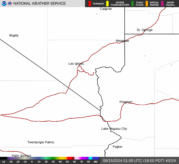
Current Radar Image
Sun Almanac for Lockes, Nevada
Sunrise: 05:53 AM
Sunset: 7:29 PM
Civil Sunrise:05:25 AM
Civil Sunset: 7:57 PM
Nautical Sunrise: 04:51 AM
Nautical Sunset: 8:31 PM
Astro Sunrise: 04:16 AM
Astro Sunset: 9:07 PM
Nevada's Current Temperatures
 Nevada's Satellite Image
 Nevada's Current Wind Direction
| National Summary |
of upper and lower values of current conditions amongst 6770 locations
in the contiguous United States |
|
High
Temp |
93° |
Presidio, Texas
|
|
Low
Temp |
-31° |
Front Royal, Virginia
|
|
Wind
Speed |
32mph |
Edwards AFB, California
|
|
Wind
Gust |
56mph |
Greenville, Maine
|
|
Wind
Chill |
8° |
Frenchville, Maine
|
|
High
Pressure |
30.36Hg |
Salida Mountain, Colorado
|
|
Low
Pressure |
29.69Hg |
Malta, Montana
and 1 other location
|
|
| # Locations Reporting Snow |
4 |
|
| # Locations Reporting Rain |
17 |
|
| # Locations Reporting Thunderstorms / Lightning |
3 |
|
| Average Temperature in the Contiguous USA |
61° |
|
Any use of the information on this page is at your own risk. This information should not be relied upon in life-threatening situations, potential financial loss situations or in lieu of any officially disseminated information. Visit the
National Weather Service for official information.