Whitharral, Texas Weather
Issued: 7:00 pm CDT Apr 24, 2024 Latitude: 33.7375948 Longitude: -102.3271221 View on Google Maps
|
|
|
|
|
|
|
|
|
|
 |
 |
 |
|
|
|
|
 |
| Low: °F |
High: °F |
High: °F |
High: °F |
High: °F |
High: °F |
High: °F |
High: °F |
| Low: °F |
Low: °F |
Low: °F |
Low: °F |
Low: °F |
Low: °F |
|
| Mostly Cloudy |
Dust |
Sunny |
Dust |
Sunny |
Sunny |
Sunny |
Thunderstorms |
Current Conditions at
LUBBOCK - (KLBB)
79°
Mostly Cloudy
as of 5:53 PM CDST
Rel. Humidity: 50%
Dew Point: 59°F
Visibility: 10 Miles
Pressure: 29.99 in.
Flight Rule: VFR
Wind Data
17 MPH
150° Southeast
Cloud Level(s): Scattered at 3900ft, Scattered at 18000ft, Broken at 25000ft
Current Conditions at
PLAINVIEW - (KPVW)
68°
Partly Cloudy
as of 6:30 PM CDST
Rel. Humidity: 72%
Dew Point: 59°F
Visibility: 10 Miles
Pressure: 30.01 in.
Flight Rule: VFR
Cloud Level(s): Scattered at 4000ft
Current Conditions at
CLOVIS - (KCVN)
75°
Clear
as of 4:56 PM MDST
Rel. Humidity: 44%
Dew Point: 52°F
Visibility: 10 Miles
Pressure: 30.02 in.
Flight Rule: VFR
Wind Data
16 MPH
Gust: 20 MPH
140° Southeast
Cloud Level(s): Clear
Current Conditions at
CANNON AFB - (KCVS)
79°
Mostly Clear
as of 4:55 PM MDST
Rel. Humidity: 36%
Dew Point: 50°F
Visibility: 10 Miles
Pressure: 29.99 in.
Flight Rule: VFR
Wind Data
13 MPH
120° Southeast
Cloud Level(s): Few at 17000ft
|
Tonight... Mostly cloudy, with a low around 61. Southeast wind 10 to 15 mph. |
|
|
Thursday... Patchy blowing dust after 1pm. Cloudy through mid morning, then gradual clearing, with a high near 89. Breezy, with a south southwest wind 15 to 20 mph increasing to 20 to 25 mph in the afternoon. Winds could gust as high as 35 mph. |
|
 |
Thursday Night... Mostly clear, with a low around 53. Breezy, with a west southwest wind 20 to 25 mph decreasing to 15 to 20 mph in the evening. Winds could gust as high as 35 mph. |
|
|
Friday... Sunny, with a high near 81. Breezy, with a west wind 15 to 20 mph increasing to 20 to 25 mph in the morning. |
|
 |
Friday Night... Clear, with a low around 53. Southwest wind 15 to 20 mph decreasing to 10 to 15 mph after midnight. |
|
|
Saturday... Patchy blowing dust after 1pm. Sunny, with a high near 79. Windy, with a southwest wind 10 to 20 mph increasing to 25 to 35 mph in the afternoon. Winds could gust as high as 50 mph. |
|
 |
Saturday Night... Partly cloudy, with a low around 50. Windy, with a west wind 25 to 30 mph decreasing to 20 to 25 mph after midnight. Winds could gust as high as 45 mph. |
|
|
Sunday... Sunny, with a high near 79. West wind 15 to 20 mph. |
|
|
Sunday Night... Mostly clear, with a low around 47. West southwest wind 10 to 15 mph becoming northwest after midnight. |
|
|
Monday... Sunny, with a high near 82. |
|
|
Monday Night... Clear, with a low around 51. |
|
|
Tuesday... Sunny, with a high near 87. |
|
 |
Tuesday Night... A slight chance of showers and thunderstorms. Partly cloudy, with a low around 58. |
|
|
Wednesday... A chance of showers and thunderstorms. Partly sunny, with a high near 83. |
|
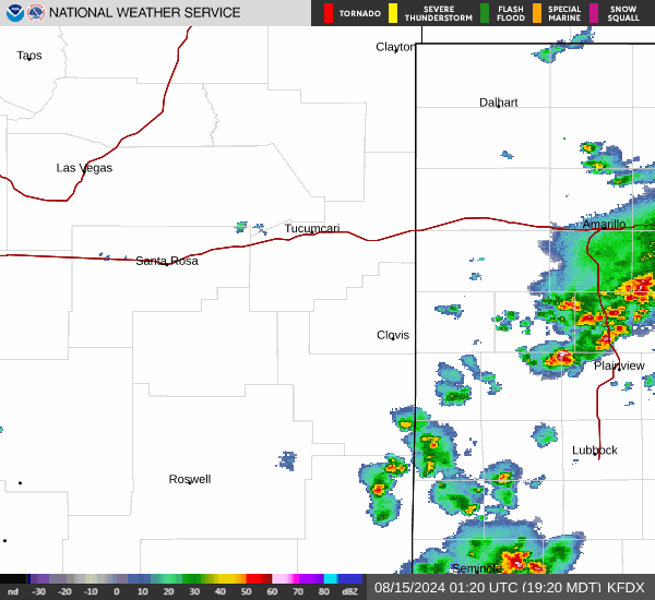
Current Radar Image
Sun Almanac for Whitharral, Texas
Sunrise: 07:07 AM
Sunset: 8:28 PM
Civil Sunrise:06:41 AM
Civil Sunset: 8:54 PM
Nautical Sunrise: 06:10 AM
Nautical Sunset: 9:25 PM
Astro Sunrise: 05:37 AM
Astro Sunset: 9:58 PM
Texas' Current Temperatures
 Texas' Satellite Image
 Texas' Current Wind Direction
| National Summary |
of upper and lower values of current conditions amongst 6943 locations
in the contiguous United States |
|
High
Temp |
95° |
Presidio, Texas
|
|
Low
Temp |
-33° |
Front Royal, Virginia
|
|
Wind
Speed |
32mph |
El Centro, California
|
|
Wind
Gust |
51mph |
Greenville, Maine
|
|
Wind
Chill |
10° |
Greenville, Maine
|
|
High
Pressure |
30.38Hg |
Salida Mountain, Colorado
|
|
Low
Pressure |
29.71Hg |
Malta, Montana
and 4 other locations
|
|
| # Locations Reporting Snow |
4 |
|
| # Locations Reporting Rain |
13 |
|
| Average Temperature in the Contiguous USA |
66° |
|
Any use of the information on this page is at your own risk. This information should not be relied upon in life-threatening situations, potential financial loss situations or in lieu of any officially disseminated information. Visit the
National Weather Service for official information.