Ruthven, Iowa Weather
your sport, your way
Air Sports Net on FacebookAir Sports Net on Google +Air Sports Net on TwitterReceive RSS UpdatesReceive Email Updates

Change location by the zip code or city,state: or search for other weather forecast locations in Iowa by name.
Weather Forecast for Ruthven, Iowa : Palo Alto County
Issued: 6:48 am CDT Apr 18, 2024 Latitude: 43.1291322 Longitude: -94.8991531 View on Google Maps

MouseOver for Detail Forecast
Today Tonight Friday Saturday Sunday Monday Tuesday Wednesday
70% chance of rain on Today Mostly Clear on Tonight Sunny on Friday Mostly Sunny on Saturday Sunny on Sunday 70% chance of rain on Monday Mostly Sunny on Tuesday Mostly Sunny on Wednesday
High: 52°F Low: 30°F High: 51°F High: 49°F High: 58°F High: 61°F High: 58°F High: 62°F
Low: 28°F Low: 28°F Low: 37°F Low: 39°F Low: 34°F  
Rain Mostly Clear Sunny Mostly Sunny Sunny Rain Mostly Sunny Mostly Sunny
-
Current Conditions at
SPENCER - (KSPW)
45°
Cloudy
as of 6:53 AM CDST
Rel. Humidity: 81%
Dew Point: 39°F
Visibility: 10 Miles
Pressure: 30.10 in.
Flight Rule: VFR
Wind Data
6 MPH
260° West
Cloud Level(s): Broken at 3600ft, Solid Overcast at 4900ft
Current Conditions at
ESTHERVILLE - (KEST)
45°
Cloudy
as of 6:52 AM CDST
Rel. Humidity: 87%
Dew Point: 41°F
Visibility: 10 Miles
Pressure: 30.08 in.
Flight Rule: VFR
Wind Data
6 MPH
230° Southwest
Cloud Level(s): Few at 3600ft, Broken at 5000ft, Solid Overcast at 10000ft
Current Conditions at
ALGONA - (KAXA)
43°
Mostly Cloudy
Mist
as of 6:55 AM CDST
Rel. Humidity: 100%
Dew Point: 43°F
Visibility: 6 Miles
Pressure: 30.07 in.
Flight Rule: VFR
Wind Data
7 MPH
300° Northwest
Cloud Level(s): Scattered at 3700ft, Broken at 4700ft, Broken at 5500ft
Current Conditions at
STORM LAKE - (KSLB)
41°
Feels like 34°F
Mostly Cloudy
Light Rain
as of 6:55 AM CDST
Rel. Humidity: 100%
Dew Point: 41°F
Visibility: 5 Miles
Pressure: 30.11 in.
Flight Rule: MVFR
Wind Data
12 MPH
320° Northwest
Cloud Level(s): Scattered at 3100ft, Broken at 4500ft, Broken at 5500ft
70% chance of rain Today 
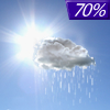
Today... Showers likely, mainly before 10am. Cloudy, then gradually becoming mostly sunny, with a high near 52. Windy, with a west northwest wind 8 to 13 mph increasing to 17 to 22 mph in the afternoon. Winds could gust as high as 31 mph. Chance of precipitation is 70%. New precipitation amounts between a tenth and quarter of an inch possible.

Mostly Clear on Tonight Tonight... Mostly clear, with a low around 30. Blustery, with a west northwest wind 9 to 18 mph, with gusts as high as 26 mph.

Sunny on Friday Friday... Sunny, with a high near 51. Windy, with a west wind 10 to 15 mph increasing to 21 to 26 mph in the afternoon. Winds could gust as high as 40 mph.

Mostly Cloudy on Friday Night Friday Night... Mostly cloudy, then gradually becoming clear, with a low around 28. Windy, with a west northwest wind 14 to 22 mph, with gusts as high as 31 mph.

Mostly Sunny on Saturday Saturday... Mostly sunny, with a high near 49. Breezy, with a northwest wind 14 to 18 mph, with gusts as high as 26 mph.

Cloudy on Saturday Night Saturday Night... Partly cloudy, with a low around 28.

Sunny on Sunday Sunday... Sunny, with a high near 58.

Cloudy on Sunday Night Sunday Night... Partly cloudy, with a low around 37.

70% chance of rain Monday Monday... Showers likely, mainly after 1pm. Mostly cloudy, with a high near 61. Windy. Chance of precipitation is 70%.

50% chance of rain Monday Night Monday Night... A 50 percent chance of showers. Mostly cloudy, with a low around 39. Breezy.

Mostly Sunny on Tuesday Tuesday... Mostly sunny, with a high near 58. Breezy.

Mostly Clear on Tuesday Night Tuesday Night... Mostly clear, with a low around 34.

Mostly Sunny on Wednesday Wednesday... Mostly sunny, with a high near 62.

Current Radar Image


Sun Almanac for Ruthven, Iowa
Sunrise: 06:31 AM
Sunset: 8:06 PM
Civil Sunrise:06:01 AM
Civil Sunset: 8:36 PM
Nautical Sunrise: 05:25 AM
Nautical Sunset: 9:12 PM
Astro Sunrise: 04:46 AM
Astro Sunset: 9:51 PM
Any use of the information on this page is at your own risk. This information should not be relied upon in life-threatening situations, potential financial loss situations or in lieu of any officially disseminated information. Visit the National Weather Service for official information.